Credit: Credit: NASA Worldview, Earth Observing System Data and Information System (EOSDIS)
The tenth named tropical cyclone of the Atlantic Ocean hurricane season was named today, Aug. 13, after NASA-NOAA’s Suomi NPP satellite provided a nighttime image of the storm.
Tropical Storm Josephine developed from Tropical Depression 11. Over the last two days, Tropical Depression 11 has been moving through the Central Atlantic Ocean and was slow to organize. Satellite imagery indicated the depression became more organized and reached tropical storm strength on Aug. 13.
Another Record-Breaker for the Season
Josephine is the earliest tenth tropical storm of record in the Atlantic, with the next earliest tenth storm being Tropical Storm Jose on August 22, 2005.
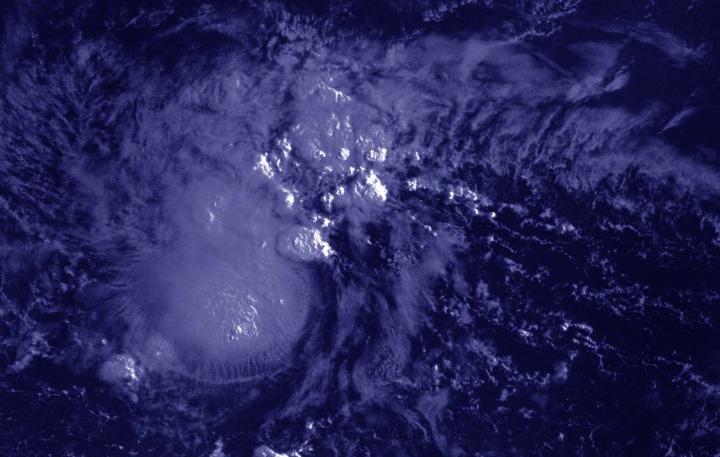
NASA’s Night-Time View
The Visible Infrared Imaging Radiometer Suite (VIIRS) instrument aboard Suomi NPP provided a nighttime image of Josephine on Aug. 13 at 2 a.m. EDT (0500 UTC). The imagery showed that Josephine had strong thunderstorms surrounding its center of circulation and fragmented thunderstorms wrapping into the low-level center from the northern quadrant. The image was created using the NASA Worldview application.
The National Hurricane Center (NHC) noted, “Satellite imagery shows that the convective pattern associated with Josephine has become a little better organized since the last advisory (at 5 a.m. EDT), with a ragged central convective feature and a weak band in the northern semicircle.”
Josephine’s Formation Advisory
At 11 a.m. EDT (1500 UTC) on Aug. 13, NHC announced the formation of Tropical Storm Josephine. At that time, the center was located near latitude 13.7 degrees north and longitude 49.2 degrees west. Josephine was located about 975 miles (1,565 km) east-southeast of the Northern Leeward Islands.
Josephine was moving toward the west-northwest near 15 mph (24 kph), and this general motion is expected to continue for the next few days followed by a turn toward the northwest late this weekend or early next week. The estimated minimum central pressure is 1005 millibars.
Recent satellite wind data indicate that maximum sustained winds have increased to near 45 mph (75 kph) with higher gusts. Some additional strengthening is forecast during the next 48 hours.
NHC cautions that interests in the Leeward Islands should monitor the progress of this system.
###
About NASA’s EOSDIS Worldview
NASA’s Earth Observing System Data and Information System (EOSDIS) Worldview application provides the capability to interactively browse over 700 global, full-resolution satellite imagery layers and then download the underlying data. Many of the available imagery layers are updated within three hours of observation, essentially showing the entire Earth as it looks “right now.”
NASA Researches Earth from Space
For more than five decades, NASA has used the vantage point of space to understand and explore our home planet, improve lives and safeguard our future. NASA brings together technology, science, and unique global Earth observations to provide societal benefits and strengthen our nation. Advancing knowledge of our home planet contributes directly to America’s leadership in space and scientific exploration.
For updated forecasts, visit: http://www.
By Rob Gutro
NASA’s Goddard Space Flight Center
Media Contact
Rob Gutro
[email protected]
Original Source
https:/


