• HOME
  • NEWS
  • EXPLORE
    • CAREER
      • Companies
      • Jobs
    • EVENTS
    • iGEM
      • News
      • Team
    • PHOTOS
    • VIDEO
    • WIKI
  • BLOG
  • COMMUNITY
    • FACEBOOK
    • INSTAGRAM
    • TWITTER
  • CONTACT US
Thursday, June 1, 2023
BIOENGINEER.ORG
No Result
View All Result
  • Login
  • HOME
  • NEWS
  • EXPLORE
    • CAREER
      • Companies
      • Jobs
        • Lecturer
        • PhD Studentship
        • Postdoc
        • Research Assistant
    • EVENTS
    • iGEM
      • News
      • Team
    • PHOTOS
    • VIDEO
    • WIKI
  • BLOG
  • COMMUNITY
    • FACEBOOK
    • INSTAGRAM
    • TWITTER
  • CONTACT US
No Result
View All Result
Bioengineer.org
No Result
View All Result
Home NEWS Science News Science

Satellites analyzing developing gulf potential Tropical Cyclone Two

Bioengineer by Bioengineer
July 10, 2019
in Science
Reading Time: 3 mins read
0
Share on FacebookShare on TwitterShare on LinkedinShare on RedditShare on Telegram

IMAGE

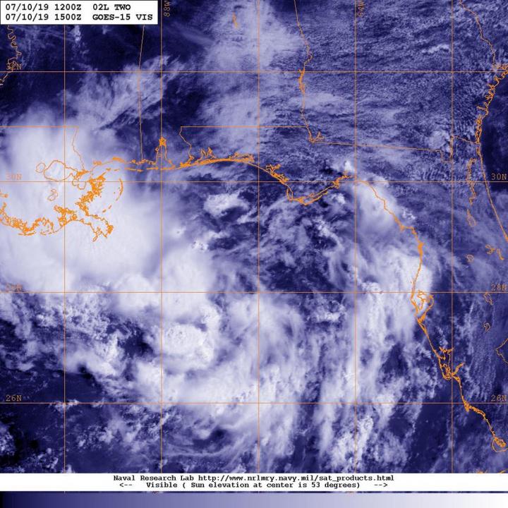
Credit: Credit: NOAA/NRL

A massive complex of thunderstorms over the southeastern United States slid into the northeastern Gulf of Mexico and now has the potential to develop into a tropical cyclone. NOAA’s National Hurricane Center or NHC in Miami, Florida issued the first advisory of Potential Tropical Cyclone Two and NOAA’s GOES-East satellite and NASA’s GPM satellite provided views of the storm.

On July 10 at 11 a.m. EDT (1500 UTC), NOAA’s GOES-East satellite provided a visible image of the developing storm. The NHC said, “High-resolution satellite imagery along with surface and upper-air data indicate that the broad low pressure system located over the northeastern Gulf of Mexico has become a little better defined.”

The Global Precipitation Measurement mission or GPM core satellite passed over the developing area of low pressure early on July 10 and found rain was falling at a rate of more than 50 mm (about 2 inches) per hour. Forecasters at the NHC said that the system has the potential to produce very heavy rainfall along and inland of the central Gulf Coast through early next week. GPM is a joint mission between NASA and the Japan Aerospace Exploration Agency, JAXA.

NHC noted, “A tropical cyclone is expected to form by Thursday [July 11] over the north-central Gulf of Mexico. At 2 p.m. EDT on July 10, NHC reported that heavy rains and flooding were already occurring over portions of southeastern Louisiana.

Because this developing area of low pressure has the potential to bring tropical storm conditions and storm surge to portions of the coast of Louisiana by late Thursday or Friday, the NHC initiated Potential Tropical Cyclone advisories. A Storm Surge Watch is in effect from the mouth of the Pearl River to Morgan City, Louisiana and a Tropical Storm Watch is in effect from the mouth of the Mississippi River to Morgan City.

At 2 p.m. EDT (1800 UTC), the disturbance was centered near latitude 28.3 degrees north and longitude 86.7 degrees west. That’s about 155 miles (250 km) east-southeast of the mouth of the Mississippi River. The system is moving toward the west-southwest near 8 mph (13 kph). On the forecast track, the system is expected to approach the central U.S. Gulf Coast this weekend.

Maximum sustained winds are near 30 mph (45 kph) with higher gusts. Strengthening is forecast during the next 72 hours, and the disturbance is forecast to become a tropical depression Thursday morning, a tropical storm Thursday night, and a hurricane on Friday, July 12. The estimated minimum central pressure is 1011 millibars. The chance the system will develop into a tropical depression in the next 48 hours is near 100 percent.

Residents along the Gulf need to heed the warnings issued by the National Hurricane Center and National Weather Service local offices. Already, Flash Flood Watches and Warnings were in effect today in southern Louisiana including New Orleans.

Dangerous storm surge is possible in portions of southeast Louisiana and the risk for dangerous storm surge impacts also exists farther west along the Louisiana coast into the Upper Texas coast. The National Weather Service Office in New Orleans issued a local statement today that also urged residents to prepare for dangerous rainfall flooding having possible significant impacts across extreme southeast Louisiana and coastal Mississippi.

For forecast updates on the system, visit: http://www.nhc.noaa.gov.

###

Media Contact
Rob Gutro
[email protected]

Original Source

https://blogs.nasa.gov/hurricanes/2019/07/10/td2-atlantic-ocean/

Tags: Atmospheric ChemistryAtmospheric ScienceClimate ChangeClimate ScienceEarth ScienceMeteorologyTechnology/Engineering/Computer ScienceTemperature-Dependent PhenomenaWeather/Storms
Share12Tweet8Share2ShareShareShare2

Related Posts

Five or more hours of smartphone usage per day may increase obesity

July 25, 2019
IMAGE

NASA’s terra satellite finds tropical storm 07W’s strength on the side

July 25, 2019

NASA finds one burst of energy in weakening Depression Dalila

July 25, 2019

Researcher’s innovative flood mapping helps water and emergency management officials

July 25, 2019
Please login to join discussion

POPULAR NEWS

  • plants

    Plants remove cancer causing toxins from air

    40 shares
    Share 16 Tweet 10
  • Element creation in the lab deepens understanding of surface explosions on neutron stars

    36 shares
    Share 14 Tweet 9
  • Groundbreaking study uncovers first evidence of long-term directionality in the origination of human mutation, fundamentally challenging Neo-Darwinism

    115 shares
    Share 46 Tweet 29
  • How life and geology worked together to forge Earth’s nutrient rich crust

    35 shares
    Share 14 Tweet 9

About

We bring you the latest biotechnology news from best research centers and universities around the world. Check our website.

Follow us

Recent News

DNA damage repaired by antioxidant enzymes

Petit-spot volcanoes involve the deepest known submarine hydrothermal activity, possibly release CO2 and methane

Producing large, clean 2D materials made easy: just KISS

Subscribe to Blog via Email

Enter your email address to subscribe to this blog and receive notifications of new posts by email.

Join 50 other subscribers
  • Contact Us

Bioengineer.org © Copyright 2023 All Rights Reserved.

No Result
View All Result
  • Homepages
    • Home Page 1
    • Home Page 2
  • News
  • National
  • Business
  • Health
  • Lifestyle
  • Science

Bioengineer.org © Copyright 2023 All Rights Reserved.

Welcome Back!

Login to your account below

Forgotten Password?

Retrieve your password

Please enter your username or email address to reset your password.

Log In