• HOME
  • NEWS
  • EXPLORE
    • CAREER
      • Companies
      • Jobs
    • EVENTS
    • iGEM
      • News
      • Team
    • PHOTOS
    • VIDEO
    • WIKI
  • BLOG
  • COMMUNITY
    • FACEBOOK
    • INSTAGRAM
    • TWITTER
Thursday, March 26, 2026
BIOENGINEER.ORG
No Result
View All Result
  • Login
  • HOME
  • NEWS
  • EXPLORE
    • CAREER
      • Companies
      • Jobs
        • Lecturer
        • PhD Studentship
        • Postdoc
        • Research Assistant
    • EVENTS
    • iGEM
      • News
      • Team
    • PHOTOS
    • VIDEO
    • WIKI
  • BLOG
  • COMMUNITY
    • FACEBOOK
    • INSTAGRAM
    • TWITTER
No Result
View All Result
Bioengineer.org
No Result
View All Result
Home NEWS Science News Biology

NOAA/NASA’s Suomi NPP satellite shows two views of California’s smoky skies

Bioengineer by Bioengineer
August 31, 2020
in Biology
Reading Time: 3 mins read
0
IMAGE
Share on FacebookShare on TwitterShare on LinkedinShare on RedditShare on Telegram

IMAGE

Credit: NOAA/NASA

NOAA/NASA’s Suomi NPP satellite captured two images that tell the story about the smoke coming off the fires in California. One instrument on the provided a visible image of the smoke, while another analyzed the aerosol content within. The images were captured on August 30, 2020.

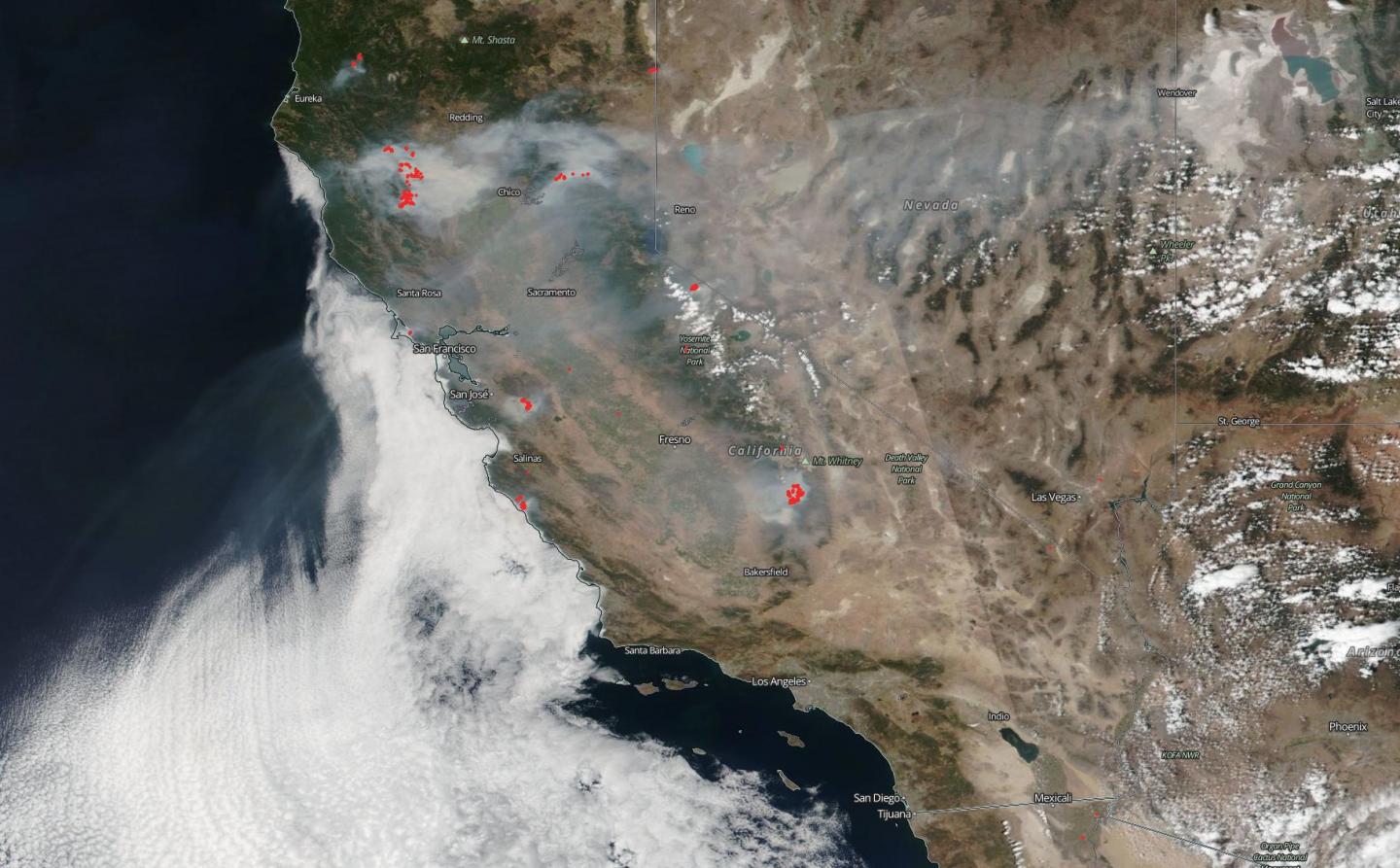
The first image captured by the Suomi NPP satellite using the VIIRS (Visible Infrared Imaging Radiometer Suite) Corrected Reflectance imagery shows a true-color image (called true-color or natural color because this combination of wavelengths is similar to what the human eye would see) of the wildfires still burning across large swaths of the state. Smoke is pouring off the fires and traveling in two different directions. Some of the smoke is traveling northeast into Nevada and as far east (in this image) as Salt Lake City, Utah, and some is traveling west into the Pacific Ocean.

The second image was captured by Suomi NPP with the OMPS Aerosol Indexer and shows not only the direction of the smoke’s travel but the thickness of the aerosol layer that has moved outward from the fires. The OMPS (Ozone Mapping and Profiler Suite) Aerosol Indexer on Suomi NPP is an instrument that indicates the presence of ultraviolet-absorbing particles in the air coming from dust (desert) or, as in this case, soot from fires. The Aerosol Indexer found on the image as a scale is unitless, that is, the lowest and highest range do not relate directly to each other. It just indicates whether the scale is low or high. In this image of smoke coming off the California fires, the aerosols found were mostly in the moderate range (yellow) with some higher range areas (red). Higher concentrations can reduce visibility and impact human health. The Aerosol index is also useful for tracking long-range transport of these aerosols that move along jet streams.

NASA’s satellite instruments are often the first to detect wildfires burning in remote regions, and the locations of new fires are sent directly to land managers worldwide within hours of the satellite overpass. Together, NASA instruments detect actively burning fires, track the transport of smoke from fires, provide information for fire management, and map the extent of changes to ecosystems, based on the extent and severity of burn scars. NASA has a fleet of Earth-observing instruments, many of which contribute to our understanding of fire in the Earth system. Satellites in orbit around the poles provide observations of the entire planet several times per day, whereas satellites in a geostationary orbit provide coarse-resolution imagery of fires, smoke and clouds every five to 15 minutes. For more information visit: https://www.nasa.gov/mission_pages/fires/main/missions/index.html

NASA’s Earth Observing System Data and Information System (EOSDIS) Worldview application provides the capability to interactively browse over 700 global, full-resolution satellite imagery layers and then download the underlying data. Many of the available imagery layers are updated within three hours of observation, essentially showing the entire Earth as it looks “right now.” Actively burning fires, detected by thermal bands, are shown as red points. Image Courtesy: NASA Worldview, Earth Observing System Data and Information System (EOSDIS).

###

By Lynn Jenner

NASA Goddard Space Flight Center

Media Contact
Lynn Jenner
[email protected]

Original Source

https://www.nasa.gov/feature/goddard/2020/noaanasas-suomi-npp-satellite-shows-two-views-of-californias-smoky-skies

Tags: AgricultureAtmospheric ChemistryAtmospheric ScienceClimate ChangeClimate ScienceEarth ScienceForestryPollution/RemediationTemperature-Dependent PhenomenaWeather/Storms
Share12Tweet8Share2ShareShareShare2

Related Posts

How to sway group opinions: Encourage opponents to stay undecided

How to sway group opinions: Encourage opponents to stay undecided

March 23, 2026
Deep Learning Model Maps How Individual Cells Shape Disease Outcomes

Deep Learning Model Maps How Individual Cells Shape Disease Outcomes

March 20, 2026

Removing only 15 female sharks annually could endanger the entire population, scientists warn

March 20, 2026

Scientists Urge Fragrance Industry to Transition from Sustainability Talk to Active Funding of Plant Conservation

March 20, 2026
Please login to join discussion

POPULAR NEWS

  • blank

    Revolutionary AI Model Enhances Precision in Detecting Food Contamination

    96 shares
    Share 38 Tweet 24
  • Imagine a Social Media Feed That Challenges Your Views Instead of Reinforcing Them

    1003 shares
    Share 397 Tweet 248
  • Uncovering Functions of Cavernous Malformation Proteins in Organoids

    54 shares
    Share 22 Tweet 14
  • Promising Outcomes from First Clinical Trials of Gene Regulation in Epilepsy

    51 shares
    Share 20 Tweet 13

About

We bring you the latest biotechnology news from best research centers and universities around the world. Check our website.

Follow us

Recent News

In-Sensor Cryptography Links Physical Process to Digital Identity

Can Psychosocial Factors Influence Cancer Risk?

Depression Factors in Elderly: Pre vs. Post-COVID Analysis

Subscribe to Blog via Email

Success! An email was just sent to confirm your subscription. Please find the email now and click 'Confirm' to start subscribing.

Join 78 other subscribers
  • Contact Us

Bioengineer.org © Copyright 2023 All Rights Reserved.

Welcome Back!

Login to your account below

Forgotten Password?

Retrieve your password

Please enter your username or email address to reset your password.

Log In
No Result
View All Result
  • Homepages
    • Home Page 1
    • Home Page 2
  • News
  • National
  • Business
  • Health
  • Lifestyle
  • Science

Bioengineer.org © Copyright 2023 All Rights Reserved.