• HOME
  • NEWS
  • EXPLORE
    • CAREER
      • Companies
      • Jobs
    • EVENTS
    • iGEM
      • News
      • Team
    • PHOTOS
    • VIDEO
    • WIKI
  • BLOG
  • COMMUNITY
    • FACEBOOK
    • INSTAGRAM
    • TWITTER
Saturday, September 5, 2026
BIOENGINEER.ORG
No Result
View All Result
  • Login
  • HOME
  • NEWS
  • EXPLORE
    • CAREER
      • Companies
      • Jobs
        • Lecturer
        • PhD Studentship
        • Postdoc
        • Research Assistant
    • EVENTS
    • iGEM
      • News
      • Team
    • PHOTOS
    • VIDEO
    • WIKI
  • BLOG
  • COMMUNITY
    • FACEBOOK
    • INSTAGRAM
    • TWITTER
  • HOME
  • NEWS
  • EXPLORE
    • CAREER
      • Companies
      • Jobs
        • Lecturer
        • PhD Studentship
        • Postdoc
        • Research Assistant
    • EVENTS
    • iGEM
      • News
      • Team
    • PHOTOS
    • VIDEO
    • WIKI
  • BLOG
  • COMMUNITY
    • FACEBOOK
    • INSTAGRAM
    • TWITTER
No Result
View All Result
Bioengineer.org
No Result
View All Result
Home NEWS Science News Science

NASA’s Aqua satellite tracks Tropical Cyclone Lorna

Bioengineer by Bioengineer
April 26, 2019
in Science
Reading Time: 2 mins read
0
IMAGE
Share on FacebookShare on TwitterShare on LinkedinShare on RedditShare on Telegram

IMAGE

Credit: Credit: NASA/NRL

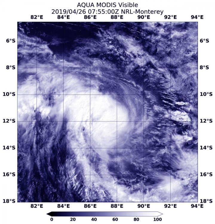
As Tropical Storm Lorna continued moving in a southerly direction in the Southeastern Indian Ocean, NASA’s Aqua satellite passed overhead and provided forecasters with a look at the storm.

At 3:55 a.m. EDT (0755 UTC) on April 26, the Moderate Resolution Imaging Spectroradiometer or MODIS instrument aboard Aqua captured a visible image of Lorna. Lorna does not appear symmetrical and the strongest thunderstorms appear over the western side of the storm. The Joint Typhoon Warning Center or JTWC forecasters also noted, “Animated enhanced infrared satellite imagery depicts a central dense overcast feature obscuring the low-level circulation center.”

By 11 a.m. EDT (1500 UTC) on April 26, Tropical Storm Lorna had maximum sustained winds near 60 knots (46 mph/74 kph). Lorna was centered near 13.0 degrees south latitude and 88.6 degrees east longitude, approximately 495 nautical miles west of Cocos Island. Lorna was moving to the east-southeast.

Lorna is forecast to strengthen to hurricane-strengthen and move in a southerly direction. Over the weekend of April 27 and 28, Lorna is expected to begin transitioning into an extra-tropical cyclone.

That means that a tropical cyclone has lost its “tropical” characteristics. The National Hurricane Center defines “extra-tropical” as a transition that implies both poleward displacement (meaning it moves toward the north or south pole) of the cyclone and the conversion of the cyclone’s primary energy source from the release of latent heat of condensation to baroclinic (the temperature contrast between warm and cold air masses) processes. It is important to note that cyclones can become extratropical and retain winds of hurricane or tropical storm force.

###

Media Contact
Rob Gutro
[email protected]

Original Source

https://blogs.nasa.gov/hurricanes/2019/04/26/lorna-southern-indian-ocean-2/

Tags: Atmospheric ChemistryAtmospheric ScienceClimate ChangeClimate ScienceEarth ScienceMeteorologyTechnology/Engineering/Computer ScienceTemperature-Dependent PhenomenaWeather/Storms
Share12Tweet8Share2ShareShareShare2

Related Posts

Five or more hours of smartphone usage per day may increase obesity

July 25, 2019
IMAGE

NASA’s terra satellite finds tropical storm 07W’s strength on the side

July 25, 2019

NASA finds one burst of energy in weakening Depression Dalila

July 25, 2019

Researcher’s innovative flood mapping helps water and emergency management officials

July 25, 2019
Please login to join discussion

POPULAR NEWS

  • Rare ZMYND11::MBTD1 fusion defines aggressive leukemia in Chinese teens and adults

    29 shares
    Share 12 Tweet 7
  • Van der Waals heterostructure boosts uncooled mid-infrared photodetector performance

    29 shares
    Share 12 Tweet 7
  • Study Reveals Why Some Residents Prepare for Disasters in Squamish

    29 shares
    Share 12 Tweet 7
  • Golgi and GRAF1-mediated endocytosis reveal hidden early stages of cilium formation

    29 shares
    Share 12 Tweet 7

About

We bring you the latest biotechnology news from best research centers and universities around the world. Check our website.

Follow us

Recent News

Rare ZMYND11::MBTD1 fusion defines aggressive leukemia in Chinese teens and adults

Van der Waals heterostructure boosts uncooled mid-infrared photodetector performance

Study Reveals Why Some Residents Prepare for Disasters in Squamish

Subscribe to Blog via Email

Enter your email address to subscribe to this blog and receive notifications of new posts by email.

Join 85 other subscribers
  • Contact Us

Bioengineer.org © Copyright 2023 All Rights Reserved.

Welcome Back!

Login to your account below

Forgotten Password?

Retrieve your password

Please enter your username or email address to reset your password.

Log In
No Result
View All Result
  • Homepages
    • Home Page 1
    • Home Page 2
  • News
  • National
  • Business
  • Health
  • Lifestyle
  • Science

Bioengineer.org © Copyright 2023 All Rights Reserved.