Credit: NASA/NRL
Tropical Depression Omar is one stubborn storm. Since it developed early in the week, it was being affected by wind shear. That wind shear has not let up by the week’s end, and NASA satellite imagery showed the bulk of storms were being pushed to the southeast of the center.
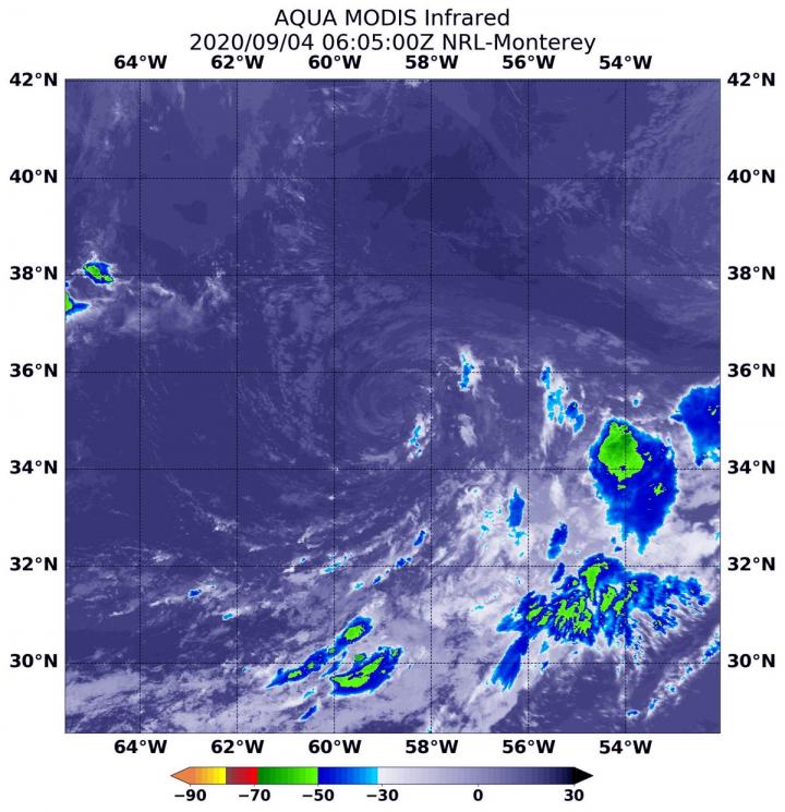
NASA’s Aqua Satellite Reveals Effects of Wind Shear
NASA’s Aqua satellite uses infrared light to analyze the strength of storms by providing temperature information about the system’s clouds. The strongest thunderstorms that reach high into the atmosphere have the coldest cloud top temperatures.
On Sept. 4 at 2:05 a.m. EDT (0605 UTC), the Moderate Resolution Imaging Spectroradiometer or MODIS instrument that flies aboard NASA’s Aqua satellite gathered infrared data on Omar that confirmed wind shear was still adversely affecting the storm. The center of circulation appears to be a swirl of clouds devoid of precipitation. In addition, satellite data reveals that some dry air is also being drawn into the circulation, which is further inhibiting the development of thunderstorms.
The only precipitation was in an area of fragmented storms pushed to the southeast of the center, as a result of strong north-northwesterly vertical wind shear. Those storms had cloud top temperatures as cold as minus 50 degrees Fahrenheit (minus 45.5 Celsius). Satellite imagery also shows the low-level circulation center became exposed.
Wind Shear Affecting Omar
The shape of a tropical cyclone provides forecasters with an idea of its organization and strength. When outside winds batter a storm, it can change the storm’s shape and push much of the associated clouds and rain to one side of it. That is what wind shear does.
In general, wind shear is a measure of how the speed and direction of winds change with altitude. Tropical cyclones are like rotating cylinders of winds. Each level needs to be stacked on top each other vertically in order for the storm to maintain strength or intensify. Wind shear occurs when winds at different levels of the atmosphere push against the rotating cylinder of winds, weakening the rotation by pushing it apart at different levels.
Omar’s Status on Friday, September 4, 2020
At 5 a.m. EDT (0900 UTC) on Sept. 4, the center of Tropical Depression Omar was located near latitude 35.3 degrees north and longitude 58.5 degrees west. That is about 415 miles (670 km) east-northeast of Bermuda. The depression is moving toward the east near 7 mph (11 km/h) and a turn toward the northeast with an increase in forward speed is expected over the next couple of days. Maximum sustained winds are near 30 mph (45 km/h) with higher gusts.
Forecast for Omar
The National Hurricane Center noted if the lack of convection continues, Omar will be declared a remnant low-pressure system later today, Sept. 4. The cyclone is expected to become absorbed by a frontal trough (elongated area of low pressure) within a couple of days.
###
NASA Researches Tropical Cyclones
Hurricanes/tropical cyclones are the most powerful weather events on Earth. NASA’s expertise in space and scientific exploration contributes to essential services provided to the American people by other federal agencies, such as hurricane weather forecasting.
For more than five decades, NASA has used the vantage point of space to understand and explore our home planet, improve lives and safeguard our future. NASA brings together technology, science, and unique global Earth observations to provide societal benefits and strengthen our nation. Advancing knowledge of our home planet contributes directly to America’s leadership in space and scientific exploration.
For updated forecasts. visit: http://www.
By Rob Gutro
NASA’s Goddard Space Flight Center
Media Contact
Rob Gutro
[email protected]
Original Source
https:/


