Credit: Credit: NASA/NRL
Once a tropical storm in the Gulf of Mexico, now a tropical depression in the Mississippi Valley, NASA’s Aqua satellite is tracking Cristobal as it continues to generate large amounts of rainfall while it heads toward the Great Lakes region.
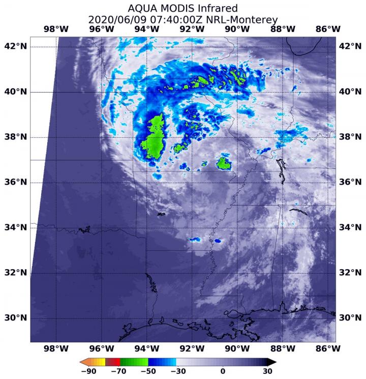
Infrared Data Reveals Strongest Storms
NASA’s Aqua satellite used infrared light to analyze the strength of storms and determine where the strongest storms were within the tropical depression. Strong storms are not evenly distributed within a tropical system, so it helps forecasters to know which side of the storm has the strongest storms and biggest rainmakers. Infrared data provides temperature information, and the strongest thunderstorms that reach high into the atmosphere have the coldest cloud top temperatures.
On June 9 at 3:40 a.m. EDT (0740 UTC) the Moderate Resolution Imaging Spectroradiometer (MODIS) instrument that flies aboard NASA’s Aqua satellite showed strongest storms in Tropical Depression Cristobal were northeast and north of the elongated center over western Missouri, Iowa and Illinois, where cloud top temperatures were as cold as minus 63 degrees Fahrenheit (minus 56.6 Celsius). NASA research has shown that storms with cloud top temperatures that cold have the ability to generate heavy rainfall.
Watches, Warnings and Rainfall Expected
On June 9, the National Weather Service Weather Prediction Center (WPC) in College Park, Md. has taken over the forecast responsibility for Cristobal, now that it is far inland. WPC issued a Flash Flood Watch for areas in and near the length of the Mississippi Valley. A Gale Warning is in effect for much of Lake Michigan, portions of eastern Lake Superior and portions of Lake Huron.
WPC forecasts “Cristobal will produce storm total rainfall accumulations of 2 to 4 inches with local amounts to 6 inches from Arkansas to the western Great Lakes through Wednesday morning. This rainfall may produce flash flooding, and is forecast to produce new and renewed minor to moderate river flooding across portions of the lower Missouri and mid to upper Mississippi Valleys. Smaller streams and rivers across southeast Louisiana, southern Mississippi, and eastern Arkansas have already begun to rise.”
Cristobal’s Status
At 5 a.m. EDT (0900 UTC), the center of Tropical Depression Cristobal was located near latitude 36.8 degrees north and longitude 92.0 degrees west. That puts the center of circulation about 140 miles (225 km) north of Little Rock, Arkansas and about 80 miles (130 km) east-southeast of Springfield, Missouri. The depression is moving toward the north near 25 mph (41 kph) and its motion is expected to accelerate to the north and north-northeast over the next 36 hours. Maximum sustained winds are near 30 mph (45 kph) with higher gusts. The estimated minimum central pressure is 995 millibars.
Cristobal Expected to Become Extra-Tropical
Often, a tropical cyclone will transform into an extra-tropical cyclone as it recurves toward the poles (north or south, depending on the hemisphere the storm is located in). Cristobal is expected to become an extra-tropical storm as it moves toward the Great Lakes region. An extra-tropical cyclone is a storm system that primarily gets its energy from the horizontal temperature contrasts that exist in the atmosphere.
Tropical cyclones have their strongest winds near the earth’s surface, while extra-tropical cyclones have their strongest winds near the tropopause – about 8 miles (12 km) up. Tropical cyclones, in contrast, typically have little to no temperature differences across the storm at the surface and their winds are derived from the release of energy due to cloud/rain formation from the warm moist air of the tropics.
Cristobal’s Path Forward
Some strengthening is forecast during the next 36 hours as Cristobal transitions into an extratropical cyclone. WPC said, “Gusty winds are expected Tuesday night and Wednesday [June 10] over portions of the Midwest and western Great Lakes as Cristobal strengthens as an extratropical low.”
For updated forecasts, visit: https:/
###
Media Contact
Rob Gutro
[email protected]
Original Source
https:/


