Credit: Credit: NASA/NRL
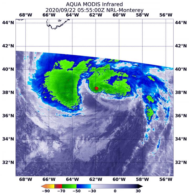
NASA’s Aqua satellite used infrared light to identify strongest storms and coldest cloud top temperatures in Hurricane Teddy as it nears eastern Canada. Teddy has triggered multiple warnings and watches.
Warnings and Watches on Sept. 22
NOAA’s National Hurricane Center noted that a Tropical Storm Warning is in effect for the south coast of Nova Scotia from Digby to Meat Cove, Canada.
A Tropical Storm Watch is in effect from Meat Cove to Tidnish, Nova Scotia, from north of Digby to Fort Lawrence, Nova Scotia. A Watch is also in effect for the Magdalen Islands, Quebec, for Port aux Basques to Francois, Newfoundland and for Prince Edward Island.
Infrared Data Reveals Powerful Storms
On Sept. 22 at 1:55 a.m. EDT (0555 UTC), the Moderate Resolution Imaging Spectroradiometer or MODIS aboard NASA’s Aqua satellite gathered temperature information about Teddy’s cloud tops. MODIS found the most powerful thunderstorms were in a very small area near the center where temperatures were as cold as or colder than minus 70 degrees Fahrenheit (minus 56.6 Celsius). Most of the rest of the storm had cloud top temperatures as cold as or colder than minus 63 degrees Fahrenheit (minus 53 degrees Celsius). Cloud top temperatures that cold indicate strong storms with the potential to generate heavy rainfall.
Recent satellite imagery shows that the central convection is diminishing, with a comma-like cloud pattern developing.
Teddy’ Status on Sept. 22
At 8 a.m. EDT (1200 UTC) on Sept. 22, the center of Hurricane Teddy was located near latitude 39.3 degrees north and longitude 63.5 degrees west. That is about 365 miles (590 km) south of Halifax, Nova Scotia, Canada.
Teddy is moving toward the north-northwest near 28 mph (44 kph), and a turn toward the north-northeast is expected by early Wednesday. Maximum sustained winds are near 105 mph (165 kph) with higher gusts. Teddy is a large hurricane. Hurricane-force winds extend outward up to 105 miles (165 km) from the center and tropical-storm-force winds extend outward up to 400 miles (645 km). The estimated minimum central pressure is 950 millibars.
Teddy’s Forecast
On the forecast track, the center will move over eastern Nova Scotia on Wednesday, Sept. 23 and then near or over Newfoundland by Wednesday night. Although some weakening is likely later today and Wednesday, Teddy should be a strong post-tropical cyclone when it moves near and over Nova Scotia.
NHC Key Messages
The National Hurricane Center’s key messages are:
WIND: Tropical storm conditions are expected to begin in the warning area by this afternoon. Tropical storm conditions could begin in the watch areas late today or early Wednesday.
SURF: Large swells generated by Teddy are affecting Bermuda, the Lesser Antilles, the Greater Antilles, the Bahamas, the east coast of the United States, and Atlantic Canada. These swells are likely to cause life-threatening surf and rip current conditions.
RAINFALL: Through Thursday, Teddy is expected to produce rainfall accumulations of 2 to 4 inches (50 to 100 mm) with isolated totals of 6 inches (150 mm) across sections of Atlantic Canada.
STORM SURGE: A dangerous storm surge is expected to produce significant coastal flooding near and to the east of where the center makes landfall in Nova Scotia. Near the coast, the surge will be accompanied by very large and destructive waves.
NASA Researches Tropical Cyclones
Hurricanes/tropical cyclones are the most powerful weather events on Earth. NASA’s expertise in space and scientific exploration contributes to essential services provided to the American people by other federal agencies, such as hurricane weather forecasting.
For more than five decades, NASA has used the vantage point of space to understand and explore our home planet, improve lives and safeguard our future. NASA brings together technology, science, and unique global Earth observations to provide societal benefits and strengthen our nation. Advancing knowledge of our home planet contributes directly to America’s leadership in space and scientific exploration.
For updated forecasts, visit: http://www.
###
Media Contact
Rob Gutro
[email protected]
Original Source
https:/


