• HOME
  • NEWS
  • EXPLORE
    • CAREER
      • Companies
      • Jobs
    • EVENTS
    • iGEM
      • News
      • Team
    • PHOTOS
    • VIDEO
    • WIKI
  • BLOG
  • COMMUNITY
    • FACEBOOK
    • INSTAGRAM
    • TWITTER
Tuesday, October 6, 2026
BIOENGINEER.ORG
No Result
View All Result
  • Login
  • HOME
  • NEWS
  • EXPLORE
    • CAREER
      • Companies
      • Jobs
        • Lecturer
        • PhD Studentship
        • Postdoc
        • Research Assistant
    • EVENTS
    • iGEM
      • News
      • Team
    • PHOTOS
    • VIDEO
    • WIKI
  • BLOG
  • COMMUNITY
    • FACEBOOK
    • INSTAGRAM
    • TWITTER
  • HOME
  • NEWS
  • EXPLORE
    • CAREER
      • Companies
      • Jobs
        • Lecturer
        • PhD Studentship
        • Postdoc
        • Research Assistant
    • EVENTS
    • iGEM
      • News
      • Team
    • PHOTOS
    • VIDEO
    • WIKI
  • BLOG
  • COMMUNITY
    • FACEBOOK
    • INSTAGRAM
    • TWITTER
No Result
View All Result
Bioengineer.org
No Result
View All Result
Home NEWS Science News

NASA satellite imagery shows wind shear affecting Tropical Storm Jerry

Bioengineer by Bioengineer
September 23, 2019
in Science News
Reading Time: 3 mins read
0
IMAGE
Share on FacebookShare on TwitterShare on LinkedinShare on RedditShare on Telegram

IMAGE

Credit: Credit: NASA Worldview, Earth Observing System Data and Information System (EOSDIS)

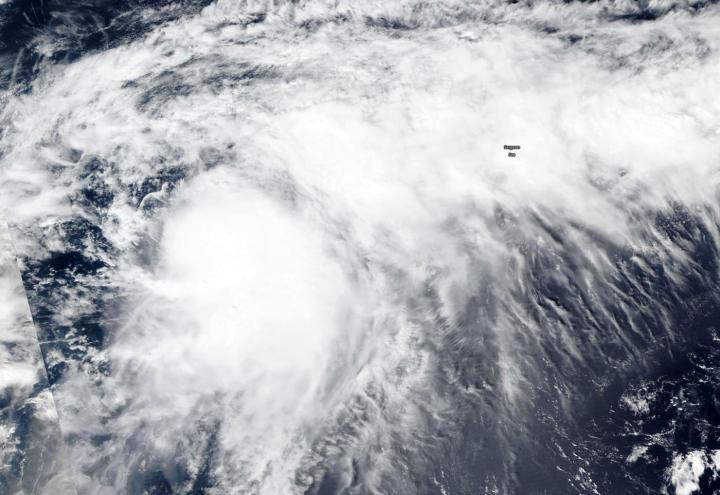
Forecasters use a variety of satellite imagery to understand what’s happening in a storm, and sometimes just a visible picture can tell a lot. NASA-NOAA’s Suomi NPP satellite provided forecasters with a visible image of the storm that showed wind shear was pushing clouds away from the storm’s center.

The shape of a tropical cyclone provides forecasters with an idea of its organization and strength. When outside winds batter a storm it can change the shape of it and push much of the associated clouds and rain to one side of it. That’s what wind shear does.

In general, wind shear is a measure of how the speed and direction of winds change with altitude. Tropical cyclones are like rotating cylinders of winds. Each level needs to be stacked on top each other vertically in order for the storm to maintain strength or intensify. Wind shear occurs when winds at different levels of the atmosphere push against the rotating cylinder of winds, weakening the rotation by pushing it apart at different levels.

Visible imagery from NASA satellites help forecasters understand if a storm is organizing or weakening, or if it is being affected by vertical wind shear. The Visible Infrared Imaging Radiometer Suite (VIIRS) instrument aboard Suomi NPP provided a visible image of Jerry on Sept. 22. The image showed the bulk of clouds associated with Jerry were pushed to the east-northeast, indicating a west-southwesterly wind shear.

NOAA’s National Hurricane Center or NHC noted that wind shear was affecting the storm on Monday, September 23, 2019. NHC noted that strong winds shear associated with an upper atmospheric, elongated low pressure area located off the southeastern U.S. coast continues to affect Jerry. That system is creating winds from the west-southwest that are pushing the bulk of Jerry’s clouds and showers to the east-northeast.

On Monday, September 23, 2019, NOAA’s National Hurricane Center issued a tropical storm warning for Bermuda.

At 11 a.m. EDT (1500 UTC), NHC reported the center of Tropical Storm Jerry was located near latitude 28.1 degrees north and longitude 68.0 degrees west. Jerry is about 345 miles (560 km) Southwest of Bermuda. Jerry is moving toward the north-northwest near 7 mph (11 kph), and this general motion should continue today. Maximum sustained winds are near 65 mph (100 kph) with higher gusts. Gradual weakening is expected during the next few days. The estimated minimum central pressure is 991 millibars.

A turn to the north is expected tonight followed by a turn to the northeast on Tuesday. On the forecast track, the center of Jerry is expected to pass near Bermuda by Tuesday night or early Wednesday. Jerry is expected to produce 1 to 3 inches of rainfall across Bermuda through Wednesday. Swells generated by Jerry are beginning to increase along the coast of Bermuda, and they will continue to affect the island during the next few days.

Hurricanes are the most powerful weather event on Earth. NASA’s expertise in space and scientific exploration contributes to essential services provided to the American people by other federal agencies, such as hurricane weather forecasting.

For updated forecasts. visit: http://www.nhc.noaa.gov

###

Media Contact
Rob Gutro
[email protected]

Original Source

https://blogs.nasa.gov/hurricanes/2019/09/23/jerry-north-atlantic-ocean-4/

Tags: Atmospheric ChemistryAtmospheric ScienceClimate ChangeClimate ScienceEarth ScienceMeteorologyTechnology/Engineering/Computer ScienceTemperature-Dependent PhenomenaWeather/Storms
Share14Tweet9Share2ShareShareShare2

Related Posts

Single-Cell Map Reveals Why Some Cholinergic Neurons Age Faster Than Others

Single-Cell Map Reveals Why Some Cholinergic Neurons Age Faster Than Others

October 6, 2026
Genetic Framework Flags Safety Risks for Inflammatory Bowel Disease Drug Targets

Genetic Framework Flags Safety Risks for Inflammatory Bowel Disease Drug Targets

October 6, 2026

Temperature and Hormone Tweaks Give Scientists a Dial to Turn Bulb Dormancy On and Off

October 6, 2026

Your Running Shoes Soften When Your Foot Tilts, Lab Tests Reveal

October 6, 2026
Please login to join discussion

POPULAR NEWS

  • Alloys That Shrink Their Own Grains: New PIX Mechanism Refines Metals With Heat Alone

    Alloys That Shrink Their Own Grains: New PIX Mechanism Refines Metals With Heat Alone

    29 shares
    Share 12 Tweet 7
  • Endurance Exercise Reshapes the Liver in Males and Females Through Distinct Molecular Routes

    29 shares
    Share 12 Tweet 7
  • Single Transcription Factor PU.1 Rapidly Converts Fibroblasts into Macrophage-Lineage Cells

    29 shares
    Share 12 Tweet 7
  • New Scale Measures How Ready Nurse Educators Really Are for the AI Era

    29 shares
    Share 12 Tweet 7

About

We bring you the latest biotechnology news from best research centers and universities around the world. Check our website.

Follow us

Recent News

Alloys That Shrink Their Own Grains: New PIX Mechanism Refines Metals With Heat Alone

Endurance Exercise Reshapes the Liver in Males and Females Through Distinct Molecular Routes

Single Transcription Factor PU.1 Rapidly Converts Fibroblasts into Macrophage-Lineage Cells

Subscribe to Blog via Email

Success! An email was just sent to confirm your subscription. Please find the email now and click 'Confirm' to start subscribing.

Join 85 other subscribers
  • Contact Us

Bioengineer.org © Copyright 2023 All Rights Reserved.

Welcome Back!

Login to your account below

Forgotten Password?

Retrieve your password

Please enter your username or email address to reset your password.

Log In
No Result
View All Result
  • Homepages
    • Home Page 1
    • Home Page 2
  • News
  • National
  • Business
  • Health
  • Lifestyle
  • Science

Bioengineer.org © Copyright 2023 All Rights Reserved.