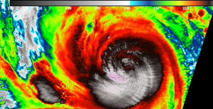
Credit: NASA/NOAA/UWM-CIMISS, William Straka III
Early on May 18, 2020, Tropical Cyclone Amphan was a Category 5 storm in the Northern Indian Ocean. On May 19, satellite data from NASA-NOAA’s Suomi NPP satellite revealed that the storm has weakened and the eye was covered by high clouds.
When NASA-NOAA’s Suomi NPP satellite passed over Tropical Cyclone Amphan on May 18 at 4:28 p.m. EDT (2028 UTC), infrared imagery revealed very cold cloud top temperatures and an obscured eye. The higher the cloud top, the colder it is, and the stronger the storm. The VIIRS instrument found several areas within where cloud top temperatures were as cold as minus 80 degrees Fahrenheit (minus 62.2 Celsius), indicating powerful storms. Storms with cloud tops that cold have been found to generate heavy rainfall.
The Joint Typhoon Warning Center noted, “Satellite imagery also revealed that the eyewall is open on the eastern side of the eye, indicative of the easterly vertical shear and mid-level dry air moving into the tropical cyclone.”
On May 19 at 5 a.m. EDT (0900 UTC), Tropical Cyclone Amphan was located near latitude 16.5 degrees north and longitude 86.8 degrees east, that is about 377 nautical miles south-southwest of Kolkata, India. Amphan was moving to the north-northeast and had maximum sustained winds near 110 knots.
Amphan is weakening as it moves north-northeast. The storm is forecast to make landfall near Kolkata on May 20 soon after 2 a.m. EDT (0600 UTC), according to the Joint Typhoon Warning Center.
###
Typhoons/hurricanes are the most powerful weather events on Earth. NASA’s expertise in space and scientific exploration contributes to essential services provided to the American people by other federal agencies, such as hurricane weather forecasting.
By Rob Gutro
NASA Goddard Space Flight Center
Media Contact
Rob Gutro
[email protected]
Original Source
https:/


