Credit: Credit: NASA/NOAA/NRL
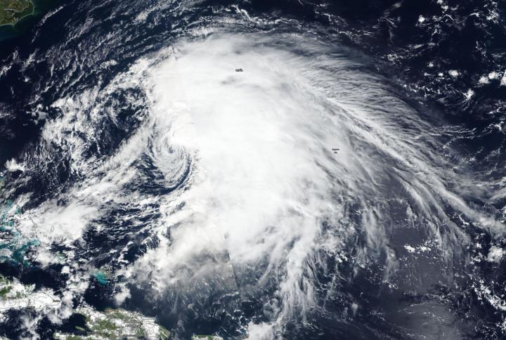
Tropical Storm Jerry continued to weaken as warnings were in effect for Bermuda on Sept. 24. Jerry appeared less organized on visible imagery from NASA-NOAA’s Suomi NPP satellite because wind shear was taking its toll on the storm.
The shape of the storm is a clue to forecasters that a storm is either strengthening or weakening. If a storm takes on a more rounded shape it is getting more organized and strengthening. Conversely, if it becomes less rounded or elongated, it is a sign the storm is weakening. Jerry is becoming elongated and weakening because of outside winds, known as wind shear.
In general, wind shear is a measure of how the speed and direction of winds change with altitude. Tropical cyclones are like rotating cylinders of winds. Each level needs to be stacked on top each other vertically in order for the storm to maintain strength or intensify. Wind shear occurs when winds at different levels of the atmosphere push against the rotating cylinder of winds, weakening the rotation by pushing it apart at different levels.
There are a couple of factors that are causing Tropical Storm Jerry to weaken. NOAA’s National Hurricane Center (NHC) reported that strong vertical wind shear and an intruding dry, stable atmosphere associated with a high amplitude mid- to upper-level area of elongated low pressure moving off of the east coast of the U.S. is finally taking its toll on Jerry.
The Visible Infrared Imaging Radiometer Suite (VIIRS) instrument aboard Suomi NPP provided a visible image of Jerry on Sept. 24. The VIIRS image showed Jerry’s cloud pattern has begun to deteriorate. Strong thunderstorm development is now only occurring on the northern quadrant of the tropical cyclone. The VIIRS image showed that the bulk of clouds and precipitation were being pushed northeast of Jerry’s center as a result of wind shear.
On Sept. 24, a Tropical Storm Warning was in effect for Bermuda. At 8 a.m. EDT (1200 UTC), the center of Tropical Storm Jerry was located near latitude 30.5 degrees north and longitude 68.9 degrees west. Jerry was 275 miles (440 km) west-southwest of Bermuda and moving toward the north at near 8 mph (13 kph). Maximum sustained winds are near 60 mph (95 kph) with higher gusts. The estimated minimum central pressure is 993 millibars.
Gradual weakening is forecast during the next few days. A turn to the northeast is expected by tonight, followed by a turn to the east-northeast on Wednesday, Sept. 25. On the forecast track, the center of Jerry is expected to pass near Bermuda on Wednesday.
Hurricanes are the most powerful weather event on Earth. NASA’s expertise in space and scientific exploration contributes to essential services provided to the American people by other federal agencies, such as hurricane weather forecasting.
###
For updated forecasts. Visit: http://www.
By Rob Gutro
NASA’s Goddard Space Flight Center
Media Contact
Rob Gutro
[email protected]
Original Source
https:/


