• HOME
  • NEWS
  • EXPLORE
    • CAREER
      • Companies
      • Jobs
    • EVENTS
    • iGEM
      • News
      • Team
    • PHOTOS
    • VIDEO
    • WIKI
  • BLOG
  • COMMUNITY
    • FACEBOOK
    • INSTAGRAM
    • TWITTER
Saturday, August 2, 2025
BIOENGINEER.ORG
No Result
View All Result
  • Login
  • HOME
  • NEWS
  • EXPLORE
    • CAREER
      • Companies
      • Jobs
        • Lecturer
        • PhD Studentship
        • Postdoc
        • Research Assistant
    • EVENTS
    • iGEM
      • News
      • Team
    • PHOTOS
    • VIDEO
    • WIKI
  • BLOG
  • COMMUNITY
    • FACEBOOK
    • INSTAGRAM
    • TWITTER
No Result
View All Result
Bioengineer.org
No Result
View All Result
Home NEWS Science News

NASA-NOAA satellite finds Tropical Storm Mario more out of shape

Bioengineer by Bioengineer
September 19, 2019
in Science News
Reading Time: 3 mins read
0
Share on FacebookShare on TwitterShare on LinkedinShare on RedditShare on Telegram

IMAGE

Credit: NASA Worldview, Earth Observing System Data and Information System (EOSDIS)

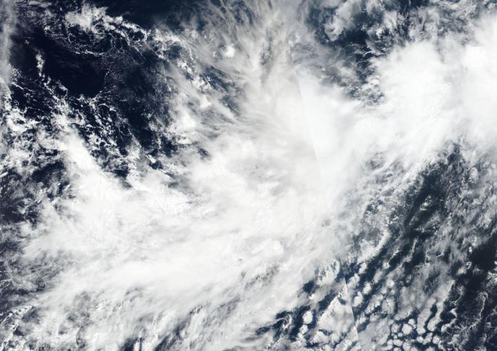
NASA-NOAA’s Suomi NPP satellite imagery revealed Tropical Storm Mario appeared to be losing its rounded shape in the Eastern Pacific Ocean.

When tropical cyclones begin to lose their shape and appear less circular, it is generally an indication of a storm that is weakening. Circular storms can spin faster, just like a tire on a car. Once the tire loses its circular shape it can’t rotate as fast.

The Visible Infrared Imaging Radiometer Suite (VIIRS) instrument aboard Suomi NPP provided a visible image of Mario on Sept. 18 at 5:36 p.m. EDT (2136 UTC) that indicated wind shear was affecting the storm as it did not appear circular as a result of wind shear. NPP data is used by forecasters at NOAA’s National Hurricane Center to assess factors of the storm that include structure and strength.

NASA’s Aqua satellite also passed over Mario and provided cloud top temperature data. Aqua showed Mario contained some powerful thunderstorms stretching high into the troposphere with cloud top temperatures as cold as or colder than 220 Kelvin (minus 63 degrees Fahrenheit / minus 53 degrees Celsius). NASA research has shown that storms with cloud top temperatures that cold can produce heavy rainfall.

NHC forecasters also utilized data to determine moderate easterly wind shear, associated at least in part with outflow from Mario’s larger sibling (Lorena) to the east, has prevented the tropical storm from strengthening at a faster rate.

In general, wind shear is a measure of how the speed and direction of winds change with altitude. Tropical cyclones are like rotating cylinders of winds. Each level needs to be stacked on top each other vertically in order for the storm to maintain strength or intensify. Wind shear occurs when winds at different levels of the atmosphere push against the rotating cylinder of winds, weakening the rotation by pushing it apart at different levels.

During the morning of Sept. 19, microwave and first-light visible imagery suggest that the low-level center of Mario may be displaced to the east of most of its strongest thunderstorms, indicating a weakening storm.

NOAA’s National Hurricane Center or NHC said, “At 11 a.m. EDT (1500 UTC), the center of Tropical Storm Mario was located near latitude 16.5 degrees north and longitude 111.5  degrees west. Mario is moving toward the north near 7 mph (11 kph). Maximum sustained winds are near 65 mph (100 kph) with higher gusts.  Little change in strength is forecast during the next several days.

Mario is currently embedded within low- to mid-layer southwesterly flow and this should cause the cyclone to move generally northeastward or north-northeastward for the next day or two. What happens after that depends largely on Lorena.

###

Hurricanes are the most powerful weather event on Earth. NASA’s expertise in space and scientific exploration contributes to essential services provided to the American people by other federal agencies, such as hurricane weather forecasting.

For updated forecasts. visit: http://www.nhc.noaa.gov

By Rob Gutro 

NASA’s Goddard Space Flight Center

Media Contact
Rob Gutro
[email protected]

Original Source

https://blogs.nasa.gov/hurricanes/2019/09/19/mario-eastern-pacific-ocean-2/

Tags: Atmospheric ChemistryAtmospheric ScienceClimate ChangeClimate ScienceEarth ScienceMeteorologyTechnology/Engineering/Computer ScienceTemperature-Dependent PhenomenaWeather/Storms
Share13Tweet8Share2ShareShareShare2

Related Posts

Macrophage-T Cell Interaction Boosts SLAMF1 in TB Defense

Macrophage-T Cell Interaction Boosts SLAMF1 in TB Defense

August 2, 2025
Strawberry Notch 1 Protects Neurons by Regulating Yeats4

Strawberry Notch 1 Protects Neurons by Regulating Yeats4

August 2, 2025

Revolutionary AI Tool Requires Minimal Data to Analyze Medical Images

August 1, 2025

Innovative Acid-Base Bifunctional Catalyst Enhances Production of Essential Lithium-Ion Battery Material

August 1, 2025
Please login to join discussion

POPULAR NEWS

  • Blind to the Burn

    Overlooked Dangers: Debunking Common Myths About Skin Cancer Risk in the U.S.

    60 shares
    Share 24 Tweet 15
  • Dr. Miriam Merad Honored with French Knighthood for Groundbreaking Contributions to Science and Medicine

    46 shares
    Share 18 Tweet 12
  • Study Reveals Beta-HPV Directly Causes Skin Cancer in Immunocompromised Individuals

    38 shares
    Share 15 Tweet 10
  • Sustainability Accelerator Chooses 41 Promising Projects Poised for Rapid Scale-Up

    35 shares
    Share 14 Tweet 9

About

We bring you the latest biotechnology news from best research centers and universities around the world. Check our website.

Follow us

Recent News

Macrophage-T Cell Interaction Boosts SLAMF1 in TB Defense

Strawberry Notch 1 Protects Neurons by Regulating Yeats4

Revolutionary AI Tool Requires Minimal Data to Analyze Medical Images

  • Contact Us

Bioengineer.org © Copyright 2023 All Rights Reserved.

Welcome Back!

Login to your account below

Forgotten Password?

Retrieve your password

Please enter your username or email address to reset your password.

Log In
No Result
View All Result
  • Homepages
    • Home Page 1
    • Home Page 2
  • News
  • National
  • Business
  • Health
  • Lifestyle
  • Science

Bioengineer.org © Copyright 2023 All Rights Reserved.