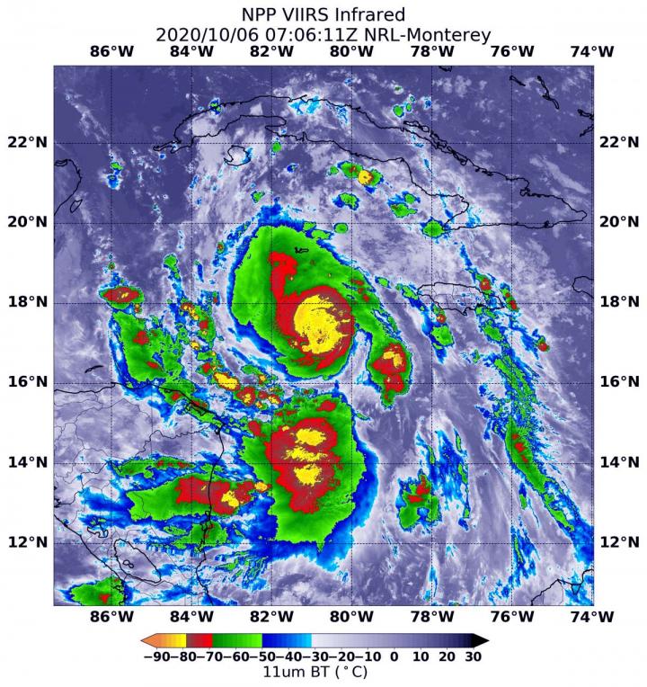
Credit: NASA/NRL
Infrared imagery from NASA-NOAA’s Suomi NPP satellite revealed that Hurricane Delta has been rapidly growing stronger and more powerful. Infrared imagery revealed that powerful thunderstorms circled the eye of the hurricane and southern quadrant as it moved through the Caribbean Sea on Oct. 6.
At 11:20 a.m. EDT on Oct. 6, NOAA’s National Hurricane Center (NHC) received data from a NOAA hurricane hunter aircraft that Delta has rapidly strengthened into a category 4 hurricane.
Infrared Imagery Reveals a More Powerful Delta
One of the ways NASA researches tropical cyclones is by using infrared data which provides temperature information. Cloud top temperatures identify where the strongest storms are located. The stronger the storms, the higher they extend into the troposphere, and the colder the cloud top temperatures.
On Oct. 6 at 3:06 a.m. EDT (0706 UTC) NASA-NOAA’s Suomi NPP satellite analyzed Hurricane Delta’s cloud top temperatures using the Visible Infrared Imaging Radiometer Suite or VIIRS instrument. At the time, Delta was a Category 1 hurricane with maximum sustained winds near 85 mph (140 kph). By 5 a.m. EDT, maximum sustained winds strengthened to 100 mph (155 kph). The storm continued to intensify rapidly during the morning hours.
VIIRS found strongest storms were around Delta’s center of circulation and in a band of thunderstorms south of the center. Temperatures in those areas were as cold as minus 80 degrees Fahrenheit (minus 62.2 Celsius). Strong storms with cloud top temperatures as cold as minus 70 degrees Fahrenheit (minus 56.6. degrees Celsius) surrounded both of those areas.
NASA research has shown that cloud top temperatures that cold indicate strong storms that have the capability to create heavy rain. NASA provides data to tropical cyclone meteorologists so they can incorporate it in their forecasts.
Warnings and Watches on Oct. 6
A Hurricane Warning is in effect from Tulum to Dzilam, Mexico and for Cozumel. A Tropical Storm Warning is in effect for the Cayman Islands including Little Cayman and Cayman Brac and for the Cuban province of Pinar del Rio and the Isle of Youth. A Tropical Storm Warning is also in effect from Punta Herrero to Tulum, Mexico and from Dzilam to Progresso, Mexico. A Tropical Storm Watch is in effect for the Cuban province of La Habana.
Delta’s Status on Oct. 6
At 11:20 a.m. EDT, data from a NOAA Hurricane Hunter aircraft indicate that Delta is continuing to strengthen rapidly. The maximum winds have increased to near 130 mph (215 kph) with higher gusts. This makes Delta a category 4 hurricane on the Saffir-Simpson Hurricane Wind Scale.
Delta was centered near latitude 18.2 degrees north and longitude 82.7 degrees west, about 315 miles (510 km) east-southeast of Cozumel, Mexico. Delta is moving to the west-northwest at 16 mph (26 kph) and has a minimum central pressure near 954 millibars.
NHC Key Messages for Delta
The NHC issued several key messages about Delta today, Oct. 6:
STORM SURGE: An extremely dangerous storm surge will raise water levels by as much as 6 to 9 feet above normal tide levels along coast of the Yucatan peninsula within the hurricane warning area, near and to right of where the center makes landfall. Near the coast, the surge will be accompanied by large and destructive waves.
WIND: Tropical storm conditions are expected in portions of the Cayman Islands today. In the Yucatan Peninsula, hurricane conditions are expected in the warning area early Wednesday, with tropical storm conditions beginning later today or tonight. Tropical storm conditions are expected in the tropical storm warning area tonight and Wednesday. In Cuba, tropical storm conditions are expected tonight in the warning area and possible in the watch area near the same time.
RAINFALL: Delta is expected to produce 4 to 6 inches of rain, with isolated maximum totals of 10 inches, across portions of the northern Yucatan Peninsula through midweek. This rainfall may result in areas of significant flash flooding.
Over the next few days, Delta is expected to produce 2 to 4 inches of rain, with isolated higher amounts, across portions of the Cayman Islands and western Cuba. This rainfall may result in areas of flash flooding and mudslides.
Delta’s Forecast
NHC noted, “A slower northwestward to north-northwest motion is forecast to begin by late Wednesday or Wednesday night. On the forecast track, the center of Delta is expected to continue to pass southwest of the Cayman Islands through early this afternoon, and move over the northeastern portion of the Yucatan peninsula late tonight or early Wednesday. Delta is forecast to move over the southern Gulf of Mexico Wednesday afternoon, and be over the southern or central Gulf of Mexico through Thursday.”
What Happened to Gamma’s Remnants?
The remnant low-pressure area of Gamma was located off the north coast of Yucatan at 8 a.m. EDT. Gamma has since moved inland and is forecast to dissipate on Wednesday.
###
NASA Researches Earth from Space
For more than five decades, NASA has used the vantage point of space to understand and explore our home planet, improve lives and safeguard our future. NASA brings together technology, science, and unique global Earth observations to provide societal benefits and strengthen our nation. Advancing knowledge of our home planet contributes directly to America’s leadership in space and scientific exploration.
For updated forecasts, visit: http://www.
By Rob Gutro
NASA’s Goddard Space Flight Center
Media Contact
Rob Gutro
[email protected]
Original Source
https:/


