Credit: NASA JPL/Heidar Thrastarson
Tropical Storm Rene weakened to a tropical depression late on Sept. 8 but regained tropical storm status on Sept. 9. Infrared imagery from NASA’s Aqua satellite captured Rene as it was twice transitioning.
Rene has been battling wind shear in the eastern North Atlantic Ocean and when NASA’s Aqua satellite passed over the storm on Sept. 8, it found Rene weakening although still a tropical storm. Wind shear occurs when winds blowing outside of a tropical cyclone at different levels of the atmosphere push against the tropical cyclone and weaken it.
NASA’s Infrared Views of Rene
Tropical cyclones are made up of hundreds of thunderstorms, and infrared data can show where the strongest storms are located. That is because infrared data provides temperature information, and the strongest thunderstorms that reach highest into the atmosphere have the coldest cloud top temperatures.
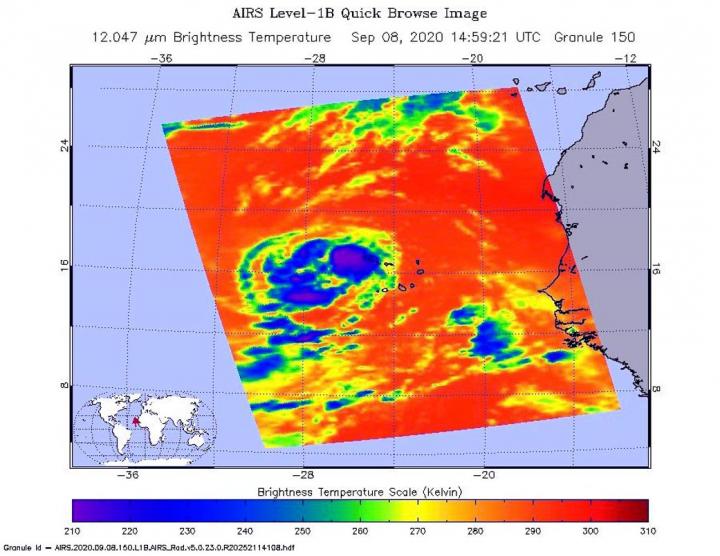
On Sept. 8 at 10:59 a.m. EDT (1459 UTC), NASA’s Aqua satellite analyzed the storm using the Atmospheric Infrared Sounder or AIRS instrument. The AIRS imagery showed the strongest storms east of the center of circulation, and in fragmented bands west of the center where coldest cloud top temperatures as cold as or colder 210 Kelvin minus 81 degrees Fahrenheit (minus 63.1 degrees Celsius). NASA research has shown that cloud top temperatures that cold indicate strong storms that have the capability to create heavy rain.
By 11 p.m. EDT on Sept. 8, although Rene had weakened to a tropical depression, infrared imagery revealed a burst of strong convection with cloud tops colder than minus 80 degrees Celsius (minus 112 Fahrenheit) had developed over and to the west of the center, while a fragmented band of convection had formed in the northern semicircle.
On Sept. 8 at 11:15 p.m. EDT (Sept. 9 at 0315 UTC), the Moderate Resolution Imaging Spectroradiometer or MODIS instrument that flies aboard NASA’s Aqua satellite used infrared light to analyze the strength of storms within Rene. MODIS showed that burst of convection and showed the most powerful thunderstorms had cloud top temperatures were as cold as or colder than minus 80 degrees Fahrenheit (minus 62.2 Celsius). Strong storms with cloud top temperatures as cold as minus 70 degrees Fahrenheit (minus 56.6. degrees Celsius) surrounded that area. NASA research has found that cloud top temperatures that cold indicate strong storms with the potential to generate heavy rainfall.
Rene’s outflow was symmetrical in all quadrants, but because scatterometer data showed that its winds dropped to 30 knots (35 mph/56 kph) per hour, it was classified as a tropical depression. Less than six hours later, infrared imagery showed Rene was becoming better organized and in an additional six hours, it would regain its strength.
On Sept. 9 at 11 a.m. EDT, Richard Pasch, Senior Hurricane Specialist at NOAA’s National Hurricane Center in Miami, Fla. noted, “Although easterly wind shear has been affecting the system, Rene is producing vigorous deep convection, along with a broad convective band, over its western semicircle. Scatterometer data indicate winds to 35 knots [40 mph/65 kph] over the northwestern quadrant, and therefore the system is again being designated as a tropical storm.”
Rene’s Status on Sept. 9
At 11 a.m. EDT (1500 UTC) on Sept. 9, Rene re-strengthened into a tropical storm. At that time, the center of Tropical Storm Rene was located near latitude 17.6 degrees north and longitude 31.5 degrees west. Rene is moving toward the west-northwest near 13 mph (20 kph). The estimated minimum central pressure is 1003 millibars. Satellite-derived wind data indicate that the maximum sustained winds have increased to near 40 mph (65 kph) with higher gusts.
Rene’s Forecast from NHC
The NHC forecasts additional strengthening during the next 48 hours and a motion toward the west-northwest is expected for the next couple of days, followed by a turn to the northwest.
###
NASA Researches Earth from Space
For more than five decades, NASA has used the vantage point of space to understand and explore our home planet, improve lives and safeguard our future. NASA brings together technology, science, and unique global Earth observations to provide societal benefits and strengthen our nation. Advancing knowledge of our home planet contributes directly to America’s leadership in space and scientific exploration.
For updated forecasts, visit: http://www.
By Rob Gutro
NASA’s Goddard Space Flight Center
Media Contact
Rob Gutro
[email protected]


