Credit: NASA/NRL
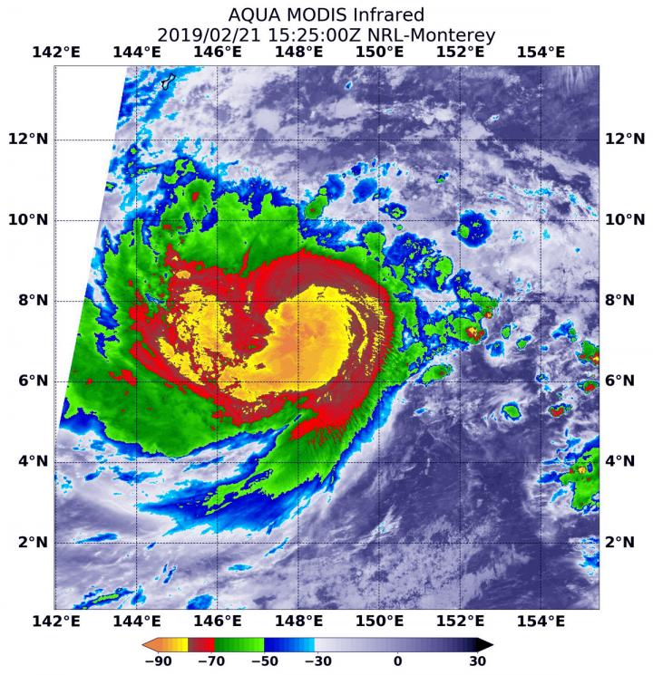
NASA’s Aqua satellite provided a look at the temperatures in Tropical Cyclone Wutip as it threatens Chuuk and Yap States in the Southern Pacific Ocean. Wutip has strengthened into a typhoon.
Infrared imagery provides scientists with a look at cloud top temperatures in tropical cyclones, and the colder the clouds, the higher up in the atmosphere and stronger the storms tend to be.
Infrared satellite data of Wutip was captured at 10:25 a.m. EDT (1525 UTC) on Feb. 21 from the Moderate Resolution Imaging Spectroradiometer or MODIS instrument aboard NASA’s Aqua satellite. MODIS data revealed powerful thunderstorms with cloud top temperatures as cold as minus 80 degrees Fahrenheit (minus 62.2 degrees Celsius) circling the center. Storms with temperatures that cold are indicative of strong storms and have been shown to have the capability to generate heavy rainfall.
The National Weather Service (NWS) in Tiyan, Guam noted that a Typhoon Warning remains in effect for Satawal in Yap State and for Puluwat in Chuuk State. A Tropical Storm Warning and Typhoon Watch remain in effect for Faraulep in Yap State. A Tropical Storm Warning remain in effect for Ulul in Chuuk State. A Tropical Storm Watch remains in effect for Guam, Rota, Tinian, and Saipan in the Mariana Islands and Woleai in Yap State.
At 10 a.m. EDT (1500 UTC) on Feb. 21 (1 a.m. CHST local time on Feb. 22) the center of Typhoon Wutip was located near Latitude 7.4 degrees North and Longitude 148.3 degrees East. Wutip is moving west-northwest at 8 mph. Wutip is expected to make a slight turn toward the northwest with an increase in forward speed over the next 24 hours. It is expected to pass southwest of the Mariana Islands late Saturday night [Feb. 23] and early Sunday morning [Feb. 24]. Maximum sustained winds have increased to 100 mph. Wutip is forecast to intensify through Saturday. Typhoon force winds extend outward from the center up to 35 miles. Tropical storm force winds extend outward from the center up to 150 miles.
Wutip is forecast to move in a northwesterly direction and its center is forecast to pass just northeast of the island of Faraulep by 7 p.m. EDT (2200 UTC) on Feb. 21 (10 a.m. CHST local time on Feb. 22) and continue tracking to the northwest.
For updated forecasts, visit: https:/
###
Media Contact
Rob Gutro
[email protected]
Original Source
https:/


