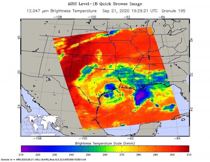
Credit: Credit: NASA JPL/Heidar Thrastarson
NASA’s Aqua satellite analyzed Tropical Storm Beta in infrared imagery to determine where the strongest parts of the storm were located. Beta is expected to stall inland over Texas today, Sept. 21, and heavy rains will continue over portions of the middle and upper Texas coast.
Beta’s center has continued to move farther inland since making landfall on the southern end of the Matagorda Peninsula around 11 p.m. EDT on Sept. 21.
One of the ways NASA researches tropical cyclones is by using infrared data that provides temperature information. The AIRS instrument aboard NASA’s Aqua satellite captured a look at those temperatures in Beta and gave insight into the size of the storm and its rainfall potential.
Infrared Data Shows Storms with Greatest Rainfall Potential
Cloud top temperatures provide information to forecasters about where the strongest storms are located within a tropical cyclone. Tropical cyclones do not always have uniform strength, and some sides are stronger than others. The stronger the storms, the higher they extend into the troposphere, and the colder the cloud top temperatures. NASA provides that data to forecasters at NOAA’s National Hurricane Center or NHC so they can incorporate into their forecasting.
The heavy rains that have been occurring over the Texas coast were found in infrared imagery from NASA. On Sept. 21 at 3:29 p.m. EDT (1929 UTC) NASA’s Aqua satellite analyzed Tropical Storm Beta using the Atmospheric Infrared Sounder or AIRS instrument. AIRS found coldest cloud top temperatures as cold as or colder than minus 63 degrees Fahrenheit (minus 53 degrees Celsius) around the center and in a thick band of storms southeast of Beta’s center. Those storms were just offshore from southeastern Louisiana and over the northern Gulf of Mexico. NASA research has shown that cloud top temperatures that cold indicate strong storms that have the capability to create heavy rain.
This snapshot of the storms that have the greatest rainfall potential help forecasters determine what areas are more subject to flooding. NOAA’s GOES-East satellite stays in a fixed position over the eastern U.S. and provides continuous infrared imagery that enables forecasters to see the movement of the areas of strongest storms.
Warnings and Watches on Sept. 21
NOAA’s National Hurricane Center issued a Storm Surge Warning on Sept. 21 from Sargent, Texas to Sabine Pass including Galveston Bay. A Tropical Storm Warning is in effect from Port Aransas, Texas to Sabine Pass.
Beta’s Status of Sept. 10
By 8 a.m. EDT CDT (1200 UTC), the center of Tropical Storm Beta was located by surface observations and NOAA Doppler radars near latitude 28.8 degrees north and longitude 96.8 degrees west. That is about 10 miles (15 km) east-southeast of Victoria and about 35 miles (55 km) west of Palacios, Texas.
Beta is moving toward the northwest near 3 mph (6 kph). Maximum sustained winds are near 40 mph (65 km/h) with higher gusts. Beta is likely to begin weakening later today. The estimated minimum central pressure is 999 millibars.
Beta’s Forecast
NHC expects Beta to stall inland over Texas today but will then begin to move slowly toward the east-northeast tonight. An east-northeast to northeast motion with increasing forward speed is expected Wednesday through Friday. On the forecast track, the center of Beta will move inland over southeastern Texas through Wednesday and then over Louisiana and Mississippi Wednesday night through Friday (Sept. 25).
NHC Key Messages
The National Hurricane Center issued three Key Messages about Beta:
Significant flash and urban flooding is occurring and will continue for the middle and upper Texas coast today. The slow motion of Beta will continue to produce a long duration rainfall event from the middle Texas coast to southern Louisiana. Flash, urban, and minor river flooding is likely. Periods of rainfall will continue into the ArkLaTex region and spread east into the Lower Mississippi Valley and portions of the Southeast through the end of the week. Flash, urban, and isolated minor river flooding is possible.
Storm surge flooding will continue throughout the morning, around the times of high tide along portions of the Texas coast within the storm surge warning areas. Residents in these areas should continue to follow advice of local officials.
Tropical-storm-force winds will continue near portions of the Texas coast within the warning area today.
NASA Researches Tropical Cyclones
Hurricanes/tropical cyclones are the most powerful weather events on Earth. NASA’s expertise in space and scientific exploration contributes to essential services provided to the American people by other federal agencies, such as hurricane weather forecasting.
The AIRS instrument is one of six instruments flying on board NASA’s Aqua satellite, launched on May 4, 2002.
For more than five decades, NASA has used the vantage point of space to understand and explore our home planet, improve lives and safeguard our future. NASA brings together technology, science, and unique global Earth observations to provide societal benefits and strengthen our nation. Advancing knowledge of our home planet contributes directly to America’s leadership in space and scientific exploration.
For updated forecasts, visit: http://www.
By Rob Gutro
NASA’s Goddard Space Flight Center
###
Media Contact
Rob Gutro
[email protected]
Original Source
https:/


