• HOME
  • NEWS
  • EXPLORE
    • CAREER
      • Companies
      • Jobs
    • EVENTS
    • iGEM
      • News
      • Team
    • PHOTOS
    • VIDEO
    • WIKI
  • BLOG
  • COMMUNITY
    • FACEBOOK
    • INSTAGRAM
    • TWITTER
Sunday, August 3, 2025
BIOENGINEER.ORG
No Result
View All Result
  • Login
  • HOME
  • NEWS
  • EXPLORE
    • CAREER
      • Companies
      • Jobs
        • Lecturer
        • PhD Studentship
        • Postdoc
        • Research Assistant
    • EVENTS
    • iGEM
      • News
      • Team
    • PHOTOS
    • VIDEO
    • WIKI
  • BLOG
  • COMMUNITY
    • FACEBOOK
    • INSTAGRAM
    • TWITTER
No Result
View All Result
Bioengineer.org
No Result
View All Result
Home NEWS Science News

NASA imagery reveals Neoguri now extra-tropical

Bioengineer by Bioengineer
October 22, 2019
in Science News
Reading Time: 2 mins read
0
Share on FacebookShare on TwitterShare on LinkedinShare on RedditShare on Telegram

IMAGE

Credit: Credit: NASA Worldview, Earth Observing System Data and Information System (EOSDIS).


Formerly a typhoon, now an extra-tropical storm, Neoguri has taken on more of a frontal system appearance in imagery from NASA’s Aqua satellite. The final warning on the system has been issued.

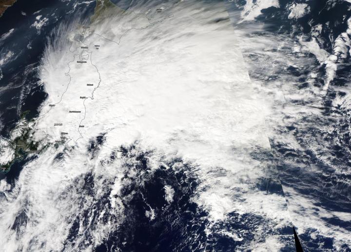
On Oct. 22, the Moderate Imaging Spectroradiometer or MODIS instrument that flies aboard NASA’s Aqua satellite provided a visible image of Neoguri. The MODIS imagery indicated that Neoguri had an elongated and poorly defined low-level circulation center with the bulk of clouds and convection (rising air that forms the thunderstorms that make up a tropical cyclone) pushed to the northeast of the center because of strong southwesterly wind shear.

What is Wind Shear?

In general, wind shear is a measure of how the speed and direction of winds change with altitude. Tropical cyclones are like rotating cylinders of winds. Each level needs to be stacked on top each other vertically in order for the storm to maintain strength or intensify. Wind shear occurs when winds at different levels of the atmosphere push against the rotating cylinder of winds, weakening the rotation by pushing it apart at different levels.

What does Extra-tropical Mean?

When a storm becomes extra-tropical, it means that a tropical cyclone has lost its “tropical” characteristics. The National Hurricane Center defines “extra-tropical” as a transition that implies both poleward displacement (meaning it moves toward the north or south pole) of the cyclone and the conversion of the cyclone’s primary energy source from the release of latent heat of condensation to baroclinic (the temperature contrast between warm and cold air masses) processes. It is important to note that cyclones can become extratropical and retain winds of hurricane or tropical storm force.

Neoguri on Oct. 22

On Oct. 22 at 5 a.m. EDT (0900 UTC), the Joint Typhoon Warning Center issued the final warning on Extra-tropical Storm Neoguri. At that time, Neoguri was centered near latitude 34.1 degrees north and longitude 141.4 degrees east. That is about 119 nautical miles south-southeast of Yokosuka, Japan. Neoguri was moving to the east-northeast and had maximum sustained winds near 45 knots (52 mph/83 kph). Neoguri is expected to intensify slightly and continue tracking northeastward.

Hurricanes are the most powerful weather event on Earth. NASA’s expertise in space and scientific exploration contributes to essential services provided to the American people by other federal agencies, such as hurricane weather forecasting.

###

Media Contact
Rob Gutro
[email protected]

Original Source

https://blogs.nasa.gov/hurricanes/2019/10/22/neoguri-northwestern-pacific-ocean-3/

Tags: Atmospheric ChemistryAtmospheric ScienceClimate ChangeClimate ScienceEarth ScienceMeteorologyTechnology/Engineering/Computer ScienceTemperature-Dependent PhenomenaWeather/Storms
Share12Tweet8Share2ShareShareShare2

Related Posts

Weight-Adjusted Waist Index Predicts Breast Cancer

Weight-Adjusted Waist Index Predicts Breast Cancer

August 3, 2025
Institutional Factors Impacting Cervical Cancer Guideline Compliance

Institutional Factors Impacting Cervical Cancer Guideline Compliance

August 3, 2025

Bright Hybrid Excitons Boost Scalable X-ray Scintillators

August 3, 2025

Tau PET Positivity Varies by Age, Genetics, and Sex

August 3, 2025
Please login to join discussion

POPULAR NEWS

  • Blind to the Burn

    Overlooked Dangers: Debunking Common Myths About Skin Cancer Risk in the U.S.

    60 shares
    Share 24 Tweet 15
  • Neuropsychiatric Risks Linked to COVID-19 Revealed

    49 shares
    Share 20 Tweet 12
  • Dr. Miriam Merad Honored with French Knighthood for Groundbreaking Contributions to Science and Medicine

    46 shares
    Share 18 Tweet 12
  • Study Reveals Beta-HPV Directly Causes Skin Cancer in Immunocompromised Individuals

    38 shares
    Share 15 Tweet 10

About

We bring you the latest biotechnology news from best research centers and universities around the world. Check our website.

Follow us

Recent News

Weight-Adjusted Waist Index Predicts Breast Cancer

Institutional Factors Impacting Cervical Cancer Guideline Compliance

Bright Hybrid Excitons Boost Scalable X-ray Scintillators

  • Contact Us

Bioengineer.org © Copyright 2023 All Rights Reserved.

Welcome Back!

Login to your account below

Forgotten Password?

Retrieve your password

Please enter your username or email address to reset your password.

Log In
No Result
View All Result
  • Homepages
    • Home Page 1
    • Home Page 2
  • News
  • National
  • Business
  • Health
  • Lifestyle
  • Science

Bioengineer.org © Copyright 2023 All Rights Reserved.