Credit: NASA JPL/Heidar Thrastarson
NASA’s Aqua satellite focused an infrared eye on a very powerful Tropical Cyclone Fani as it approached landfall in northeastern India. Fani is a powerful Category 4 hurricane on the Saffir-Simpson Hurricane Wind Scale.
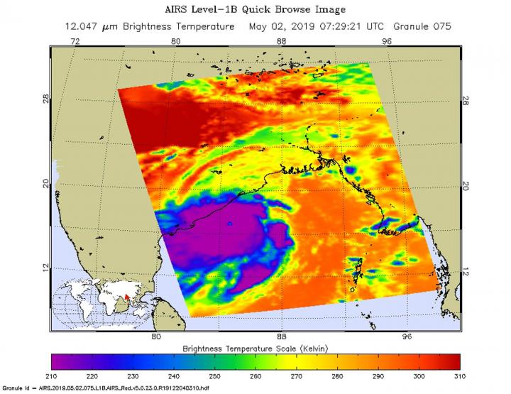
On May 2 at 3:29 a.m. EDT (0729 UTC), the Atmospheric Infrared Sounder or AIRS instrument aboard NASA’s Aqua satellite analyzed cloud top temperatures of Tropical Cyclone Fani in infrared light. AIRS found cloud top temperatures of strongest thunderstorms as cold as or colder than minus 80 degrees Fahrenheit (minus 62 degrees Celsius) circling the eye and in a fragmented band of thunderstorms east of the center. Satellite data showed there is now a 16 nautical mile-wide round, symmetrical eye surrounded by a thick band of powerful thunderstorms. Cloud top temperatures that cold indicate strong storms that have the capability to create heavy rain.
On May 2 at 11 a.m. EST (1500 UTC), the center of Tropical Cyclone Fani was located near latitude 17.6 degrees north and longitude 84.8 degrees east. That is about 87 miles east of Visakhapatnam, India. Fani was moving to the north and maximum sustained winds increased to 135 knots (155 mph/250 kph).
Fani is forecast to move to the north-northeast. The India Meteorological Department forecasts Fani to make landfall within 12 to 24 hours, then weaken rapidly and dissipate over northeastern India and Bangladesh.
###
For local forecasts, visit the India Meteorological Department: http://www.
By Rob Gutro
NASA’s Goddard Space Flight Center
Media Contact
Rob Gutro
[email protected]
Original Source
https:/


