Credit: NASA/NRL
Tropical Storm Laura strengthened to a hurricane in the morning hours of Aug. 25, and NASA provided infrared imagery that showed the structure, temperature and rainmaking capabilities of the storm. When NASA’s Terra satellite and NASA-NOAA’s Suomi NPP satellite passed overhead, both provided different images of Laura as it was about to exit the Caribbean Sea and move into the Gulf of Mexico.
Watches and Warnings on Aug. 25
On Aug. 25, NOAA’s National Hurricane Center (NHC) posted several watches and warnings.
A Storm Surge Warning is in effect from San Luis Pass Texas to the mouth of the Mississippi River, including areas inside the Port Arthur Hurricane Flood Protection system. A Hurricane Warning is in effect from San Luis Pass, Texas to Intracoastal City, Louisiana.
A Tropical Storm Warning is in effect from Sargent, Texas to San Luis Pass and from east of Intracoastal City to the mouth of the Mississippi River. A Storm Surge Watch is in effect from Freeport, Texas to San Luis Pass.
NASA’s Night-Time View of Laura’s Intensification
The Visible Infrared Imaging Radiometer Suite (VIIRS) instrument aboard Suomi NPP provided a nighttime image of Laura during the early morning hours of Aug. 25. Not yet named a hurricane, the development of an eye was apparent. By 11 a.m. EDT, Laura had a central dense overcast and some outer banding in the southern quadrant.
Satellite imagery shows the storm is over 350 miles in diameter. Hurricane-force winds extend outward up to 45 miles (75 km) from the center and tropical-storm-force winds extend outward up to 175 miles (280 km).
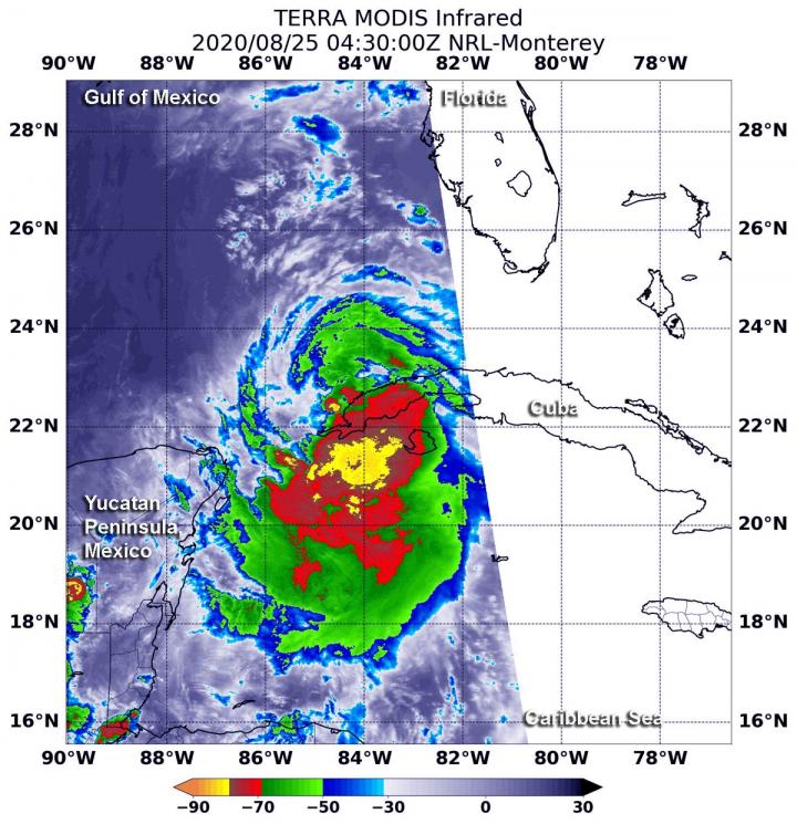
NASA’s Infrared Data Reveals Heavy Rainmakers
Tropical cyclones are made up of hundreds of thunderstorms, and infrared data can show where the strongest storms are located. That is because infrared data provides temperature information, and the strongest thunderstorms that reach highest into the atmosphere have the coldest cloud top temperatures.
On July 27 at 4:35 a.m. EDT (0835 UTC), the Moderate Resolution Imaging Spectroradiometer or MODIS instrument that flies aboard NASA’s Aqua satellite used infrared light to analyze the strength of storms within Laura. MODIS found the most powerful thunderstorms were around Laura’s center over the Caribbean Sea, just south of western Cuba, where cloud top temperatures were as cold as minus 80 degrees Fahrenheit (minus 62.2 Celsius). NASA research has found that cloud top temperatures that cold indicate strong storms with the potential to generate heavy rainfall.
Strong storms with cloud top temperatures as cold as minus 70 degrees Fahrenheit (minus 56.6. degrees Celsius) circled the most powerful storms, and were also dropping large amounts of rain.
Laura’s Status on Aug. 25, 2020
At 11 a.m. EDT (1500 UTC), the center of Hurricane Laura was located near latitude 23.7 degrees north and longitude 87.0 degrees west. That is about 585 miles (940 km) southeast of Lake Charles, Louisiana and about 620 miles (1,000 km) southeast of Galveston, Texas.
Laura was moving toward the west-northwest near 16 mph (26 kph), and this general motion should continue today, according to NHC. A turn toward the northwest is forecast by Wednesday, and a northwestward to north-northwestward motion should continue through Wednesday night. Reports from NOAA and Air Force Reserve Hurricane Hunter aircraft indicate that maximum sustained winds are near 75 mph (120 kph) with higher gusts. The estimated minimum central pressure based on the Hurricane Hunter aircraft data is 990 millibars.
Laura’s Forecast from NHC
Significant strengthening is forecast during the next 36 hours, and Laura is expected to be a major hurricane at landfall. NHC noted the forecast calls for the hurricane to make landfall in the area of southwestern Louisiana or the upper Texas coast late Wednesday night or Thursday morning.
###
About NASA’s EOSDIS Worldview
NASA’s Earth Observing System Data and Information System (EOSDIS) Worldview application provides the capability to interactively browse over 700 global, full-resolution satellite imagery layers and then download the underlying data. Many of the available imagery layers are updated within three hours of observation, essentially showing the entire Earth as it looks “right now.”
NASA Researches Earth from Space
For more than five decades, NASA has used the vantage point of space to understand and explore our home planet, improve lives and safeguard our future. NASA brings together technology, science, and unique global Earth observations to provide societal benefits and strengthen our nation. Advancing knowledge of our home planet contributes directly to America’s leadership in space and scientific exploration.
For updated forecasts, visit: http://www.
By Rob Gutro
NASA’s Goddard Space Flight Center
Media Contact
Rob Gutro
[email protected]
Original Source
https:/


