Credit: Image Courtesy: NASA/NRL
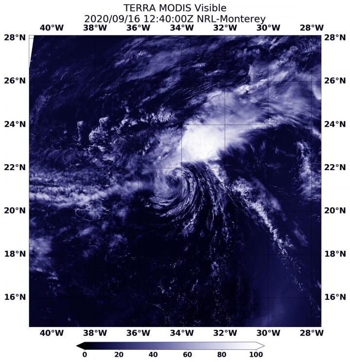
NASA’s Terra satellite obtained visible imagery of Tropical Storm Vicky as it continued moving through the eastern North Atlantic Ocean fighting strong wind shear. Outside winds are pushing at the storm and weakening it.
Terra Sees Wind Shear Tearing Vicky Apart
On Sept. 16, 2020 at 8:40 a.m. EDT (1240 UTC), the Moderate Resolution Imaging Spectroradiometer or MODIS instrument that flies aboard NASA’s Terra satellite captured a visible image of Tropical Storm Vicky battling strong southwesterly wind shear. The image showed wispy clouds had surrounded the center of circulation, while the wind shear was blowing the bulk of clouds and showers to the northeast of the center.
NASA’s Terra satellite is one in a fleet of NASA satellites that provide data for hurricane research.
About Wind Shear
The shape of a tropical cyclone provides forecasters with an idea of its organization and strength. When outside winds, or wind shear batters a storm, it can change the shape of it by pushing much of the associated clouds and rain to one side. Vicky has been in an area with strong southwesterly wind shear.
Dr. Michael Brennan, Branch Chief of NOAA’s National Hurricane Center noted in the 11 a.m. EDT (1500 UTC) Discussion, “Hostile vertical shear of 50 to 60 knots has finally taken a toll on Vicky. A 1227 UTC ASCAT-B overpass showed peak winds of 35 knots north of the center, and that is the basis for the advisory intensity. The strong shear is expected to continue while Vicky moves over marginal 26-27 degrees Celsius sea surface temperatures, so additional weakening is forecast. Vicky should become a tropical depression in around 24 hours before weakening to a remnant low in about 2 days, with dissipation expected by day 3.”
Vicky on Sept. 16
NOAA’s National Hurricane Center (NHC) noted at 5 a.m. EDT (0900 UTC), the center of Tropical Storm Vicky was located near latitude 21.6 degrees north and longitude 33.9 degrees west. Vicky is centered about 755 miles (1,215 km) west-northwest of the Cabo Verde Islands. Vicky is moving toward the west-northwest near 9 mph (15 kph). Maximum sustained winds are near 50 mph (85 km/h) with higher gusts. The estimated minimum central pressure is 1004 millibars.
Weakening Forecast for Vicky
A westward motion is expected to begin later today, followed by a west-southwestward motion by late Thursday [Sept. 17]. Gradual weakening is forecast over the next few days, and the system could become a remnant low on Thursday or Friday.
NASA Researches Earth from Space
For more than five decades, NASA has used the vantage point of space to understand and explore our home planet, improve lives and safeguard our future. NASA brings together technology, science, and unique global Earth observations to provide societal benefits and strengthen our nation. Advancing knowledge of our home planet contributes directly to America’s leadership in space and scientific exploration.
For updated forecasts, visit: http://www.
By Rob Gutro
NASA’s Goddard Space Flight Center
###
Media Contact
Rob Gutro
[email protected]
Original Source
https:/


