Credit: Image Courtesy: NASA Worldview, Earth Observing System Data and Information System (EOSDIS).
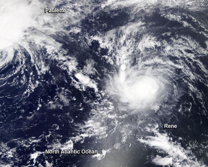
NASA’s Terra satellite obtained visible imagery of Tropical Storm Rene is it continued moving north though the central North Atlantic Ocean. Rene appeared more organized on satellite imagery as wind shear eased.
NASA Satellite View: Rene’s Organization
The Moderate Resolution Imaging Spectroradiometer or MODIS instrument that flies aboard NASA’s Terra satellite captured a visible image of Tropical Storm Rene on Sept. 10. Rene appeared slightly more circular. That is because vertical wind shear (outside winds blowing at different levels of the atmosphere) appears to have lessened somewhat over Rene allowing the storm to organize. The image showed Tropical Storm Paulette was located to Rene’s northwest.
Satellite imagery was created using NASA’s Worldview product at NASA’s Goddard Space Flight Center in Greenbelt, Md.
Rene on Sept. 10
At 11 a.m. EDT (1500 UTC) on Sept. 10, the center of Tropical Storm Rene was located near latitude 18.6 degrees north and longitude 35.8 degrees west. Rene was about 800 miles (1,285 km) west-northwest of the Cabo Verde Islands.
Rene is moving toward the west-northwest near 12 mph (19 kph). This general motion is expected to continue for the next couple of days, followed by a turn toward the northwest. Maximum sustained winds have increased to near 50 mph (85 kph) with higher gusts. The estimated minimum central pressure is 1000 millibars.
NOAA’s National Hurricane Center (NHC) noted that additional strengthening is forecast for the next couple of days as vertical wind shear is not expected to be strong. Therefore, Rene is expected to become a hurricane by Saturday, Sept. 12. The storm is not expected to affect any land areas in the next five days, according to the NHC forecast.
###
About NASA’s Worldview and Terra Satellite
NASA’s Earth Observing System Data and Information System (EOSDIS) Worldview application provides the capability to interactively browse over 700 global, full-resolution satellite imagery layers and then download the underlying data. Many of the available imagery layers are updated within three hours of observation, essentially showing the entire Earth as it looks “right now.”
NASA’s Terra satellite is one in a fleet of NASA satellites that provide data for hurricane research.
Tropical cyclones/hurricanes are the most powerful weather events on Earth. NASA’s expertise in space and scientific exploration contributes to essential services provided to the American people by other federal agencies, such as hurricane weather forecasting.
For updated forecasts, visit: http://www.
By Rob Gutro
NASA’s Goddard Space Flight Center
Media Contact
Rob Gutro
[email protected]
Original Source
https:/


