Credit: NASA/JAXA/NRL
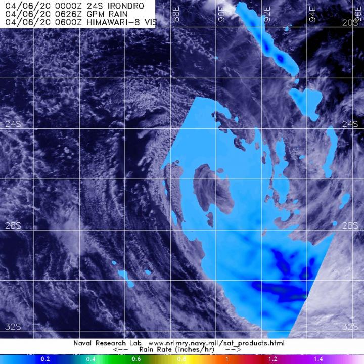
NASA analyzed Tropical Storm Irondro’s rainfall and found heaviest rainfall was being pushed far southeast of the center because of strong wind shear.
NASA has the unique capability of peering under the clouds in storms and measuring the rate in which rain is falling. Global Precipitation Measurement mission or GPM core passed over Irondro from its orbit in space and measured rainfall rates throughout the storm on Apr. 6 at 2:26 a.m. EDT (0626 UTC). Heaviest rainfall was being pushed southeast of the center where it was falling at a rate of 1 inch (25 mm) per hour. Light rain was found throughout the rest of the storm.
In general, wind shear is a measure of how the speed and direction of winds change with altitude. Tropical cyclones are like rotating cylinders of winds. Each level needs to be stacked on top each other vertically in order for the storm to maintain strength or intensify. Wind shear occurs when winds at different levels of the atmosphere push against the rotating cylinder of winds, weakening the rotation by pushing it apart at different levels. Winds from the northwest were pushing against the storm and displacing the heaviest rainfall southeast of the center.
On Apr. 6 at 4 a.m. EDT (0900 UTC), the Joint Typhoon Warning Center issued their final warning on Irondro. Despite the wind shear, Tropical Storm Irondro had maximum sustained winds near 40 knots (46 mph/74 kph). Irondro was located near latitude 26.7 degrees south and longitude 89.5 degrees east. Irondro is becoming extra-tropical and is expected to become a cold core low pressure area later in the day.
Typhoons/hurricanes are the most powerful weather events on Earth. NASA’s expertise in space and scientific exploration contributes to essential services provided to the American people by other federal agencies, such as hurricane weather forecasting.
Both the Japan Aerospace Exploration Agency, JAXA and NASA manage GPM.
###
Media Contact
Rob Gutro
[email protected]
Original Source
https:/


