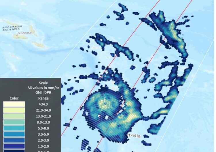
Credit: Credit: JAXA/Jason West, NASA EOSDIS
One of NASA’s satellites that can measure the rate in which rainfall is occurring in storms passed over powerful Tropical Cyclone Harold just after it made landfall in Vanuatu in the Southern Pacific Ocean.
Tropical Cyclone Harold developed from a low-pressure system that was observed to the east of Papua New Guinea last week, and has tracked to the southeast, where it has already caused flooding and loss of life in the Solomon Islands.
Now a Category 4 cyclone, the most powerful yet of 2020, Harold made landfall on the South Pacific nation of Vanuatu on Monday, April 6, not long before the Global Precipitation Measurement mission or GPM passed overhead. GPM’s Dual-frequency Precipitation Radar and GPM Microwave Imager data provided data on rainfall rates. “The highest rates were in the rain band to the southeast of the eye, at 48 mm (1.8 inches) per hour,” said B. Jason West, Science Data Analyst at NASA’s Goddard Space Flight Center in Greenbelt, Md. “Near the eye, rates in some areas also exceeded 40 mm (1.6 inches) per hour.”
Early reports from Vanuatu indicate heavy flooding and property damage.
The Vanuatu Meteorological Service (VMS) posted Tropical Cyclone Warning Number 27 for the Sanma, Penama, Malampa and Shefa Provinces. At 8 a.m. EDT (11:00 p.m. Vanuatu local time), VMS noted that “Severe Tropical Cyclone Harold was located at latitude 16.0 degrees south and longitude 168.8 degrees east, about 80 kilometers (50 miles) east northeast of Ambrym and 105 km (65 miles) northeast of Epi. Severe Tropical Cyclone Harold has been moving in an east-southeasterly direction at 19 kph (10 knots/12 mph) in the past 3 hours. Maximum sustained winds close to the center are estimated at 230 kph (125 Knots/143 mph).
The VMS warning noted, “Damaging gale force winds, destructive storm force winds and hurricane force winds with heavy rainfalls and flash flooding over low lying areas and areas close to river banks including coastal flooding is expected over Sanma, Penama, Malampa and Shefa Provinces including Torba province tonight. Very rough to phenomenal seas with heavy to phenomenal swells are expected over northern and central open and coastal waters tonight as the system continues to move over the Central Islands of Vanuatu. High Seas wind warning and a Marine strong wind warning are current for all coastal and open waters of Vanuatu. People, including sea-going vessels are strongly advised not to go out to sea within affected area until the system has moved out of the area.”
The Vanuatu National Disaster Management Office (NDMO) advises that Red Alert is in effect for Sanma, Penama, Malampa and Shefa Provinces, while Yellow Alert for Torba provinces.
###
The Vanuatu Meteorology and Geo-Hazards Department updates are available on VMGD’s website: https:/
Harold is forecast to continue to Fiji later this week.
By Rob Gutro
NASA’s Goddard Space Flight Center
Media Contact
Rob Gutro
[email protected]
Original Source
https:/


