Credit: Credit: NASA Worldview
During the afternoon of Aug. 26, as major Hurricane Laura nears landfall near the Texas/Louisiana border, NASA satellites have been providing forecasters with a great deal of data on the storm, examining temperature, rainfall capability, storm structure and extent.
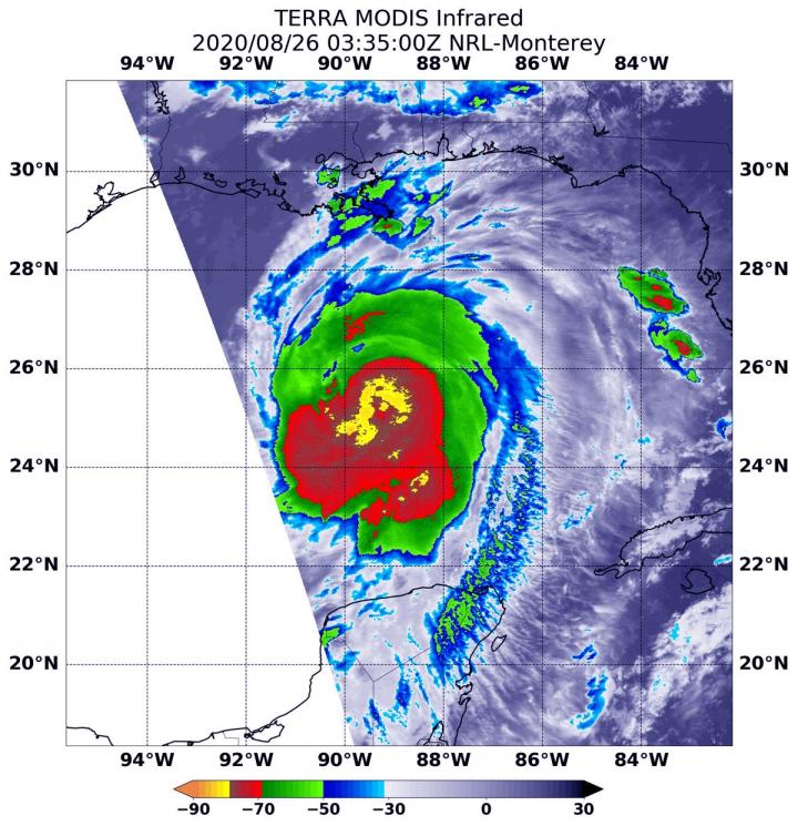
Infrared Data Reveals Powerful Rainmaking Capabilities
On Aug. 25 at 11:35 p.m. EDT (Aug. 26 at 0335 UTC) the Moderate Resolution Imaging Spectroradiometer or MODIS instrument that flies aboard NASA’s Aqua satellite revealed the most powerful thunderstorms were around Laura’s center where cloud top temperatures were as cold as minus 80 degrees Fahrenheit (minus 62.2 Celsius). Strong storms with cloud top temperatures as cold as minus 70 degrees Fahrenheit (minus 56.6. degrees Celsius) surrounded the center and were generating large amounts of rain. NASA research has determined that cloud top temperatures as cold as or colder than minus 63 degrees Fahrenheit (minus 52.7 degrees Celsius) has the capability to generate heavy rainfall.
NASA’s Visible Image Of Cat 4 Hurricane Laura on Aug. 26
The MODIS instrument aboard NASA’s Terra satellite provided a visible image of the large and powerful major Hurricane Laura in the Gulf of Mexico on Aug. 26, 2020 at 2:30 p.m. EDT. Laura’s eye was clearly visible, the storm was well rounded, and the eye was surrounded by powerful thunderstorms.
Watches and Warnings on Aug. 25
On Aug. 25, NOAA’s National Hurricane Center (NHC) posted several watches and warnings on major Hurricane Laura.
A Storm Surge Warning is in effect for San Luis Pass, Texas to the mouth of the Mississippi River. A Storm Surge Warning means there is a danger of life-threatening inundation, from rising water moving inland from the coastline, during the next 36 hours in the indicated locations. Some of the storm surge forecasts are extreme. Johnson Bayou, LA to Rockefeller Wildlife Refuge including Calcasieu Lake is between 15 to 20 feet. Sea Rim State Park, TX to Johnson Bayou, LA including Sabine Lake is between 10 and 15 feet. Rockefeller Wildlife Refuge to Intracoastal City, LA between 10 and 15 feet. Intracoastal City, LA to Morgan City including Vermilion Bay between 8 to 12 feet. For additional areas and storm surges, visit: http://www.
A Hurricane Warning is in effect from San Luis Pass, Texas to Intracoastal City, Louisiana.
A Tropical Storm Warning is in effect from Sargent, Texas to San Luis Pass and for areas east of Intracoastal City, Louisiana to the mouth of the Mississippi River.
A Storm Surge Watch is in effect for Freeport, Texas to San Luis Pass, Texas, the mouth of the Mississippi River to Ocean Springs, Mississippi, and for Lake Pontchartrain, Lake Maurepas, and Lake Borgne.
A Hurricane Watch is in effect for from east of Intracoastal City to west of Morgan City, Louisiana.
Laura’s Status on Aug. 26, 2020 at 2 p.m. EDT
NOAA’s National Hurricane Center (NHC) reported at 2 p.m. EDT (1800 UTC), the eye of Hurricane Laura was located near latitude 27.3 degrees north and longitude 92.5 degrees west. That is about 200 miles (20 km) south-southeast of Lake Charles, Louisiana.
Laura is moving toward the northwest near 16 mph (26 kph). A gradual turn toward the north-northwest and north is expected later today and tonight. Reports from an Air Force Reserve Hurricane Hunter aircraft indicate that maximum sustained winds have increased to near 140 mph (220 kph) with higher gusts. Laura is an extremely dangerous category 4 hurricane on the Saffir-Simpson Hurricane Wind Scale. Some additional strengthening is possible this afternoon, and Laura is forecast to remain a category 4 hurricane through landfall tonight. Rapid weakening is expected after Laura makes over land.
Hurricane-force winds extend outward up to 70 miles (110 km) from the center and tropical-storm-force winds extend outward up to 175 miles (280 km). Tropical-storm-force winds have reached the coast of Louisiana and an observing site at Eugene Island recently measured sustained winds of 39 mph (63 kph) and a gust to 64 mph (104 kph).
The latest minimum central pressure estimated from reconnaissance aircraft data is 952 millibars.
Laura’s Forecast from NHC
The NHC warns that Laura will likely make landfall as a Category 4 hurricane and bring devastating effects. Heavy rain, dangerous storm surge, isolated tornadoes and hurricane-force sustained winds are expected. On the forecast track, Laura will approach the Upper Texas and southwest Louisiana coasts this evening and move inland within that area tonight. The center of Laura is forecast to move over northwestern Louisiana tomorrow, across Arkansas Thursday night, and over the mid-Mississippi Valley on Friday.
NASA Researches Earth from Space
For more than five decades, NASA has used the vantage point of space to understand and explore our home planet, improve lives and safeguard our future. NASA brings together technology, science, and unique global Earth observations to provide societal benefits and strengthen our nation. Advancing knowledge of our home planet contributes directly to America’s leadership in space and scientific exploration.
For updated and detailed forecasts, visit: http://www.
###
Media Contact
Rob Gutro
[email protected]
Original Source
https:/


