• HOME
  • NEWS
    • BIOENGINEERING
    • SCIENCE NEWS
  • EXPLORE
    • CAREER
      • Companies
      • Jobs
    • EVENTS
    • iGEM
      • News
      • Team
    • PHOTOS
    • VIDEO
    • WIKI
  • BLOG
  • COMMUNITY
    • FACEBOOK
    • FORUM
    • INSTAGRAM
    • TWITTER
  • CONTACT US
Thursday, January 28, 2021
BIOENGINEER.ORG
No Result
View All Result
  • Login
  • HOME
  • NEWS
    • BIOENGINEERING
    • SCIENCE NEWS
  • EXPLORE
    • CAREER
      • Companies
      • Jobs
        • Lecturer
        • PhD Studentship
        • Postdoc
        • Research Assistant
    • EVENTS
    • iGEM
      • News
      • Team
    • PHOTOS
    • VIDEO
    • WIKI
  • BLOG
  • COMMUNITY
    • FACEBOOK
    • FORUM
    • INSTAGRAM
    • TWITTER
  • CONTACT US
No Result
View All Result
Bioengineer.org
No Result
View All Result
Home NEWS Science News

NASA animation tracks the end of Tropical Storm Delta  

Bioengineer by Bioengineer
October 13, 2020
in Science News
0
Share on FacebookShare on TwitterShare on LinkedinShare on RedditShare on Telegram

IMAGE

Credit: Image Courtesy: NASA Worldview, Earth Observing System Data and Information System (EOSDIS).

NASA’s Terra satellite obtained visible imagery as Tropical Storm Delta made landfall in Louisiana and moved northeastward soaking the U.S. southeast and Mid-Atlantic states.

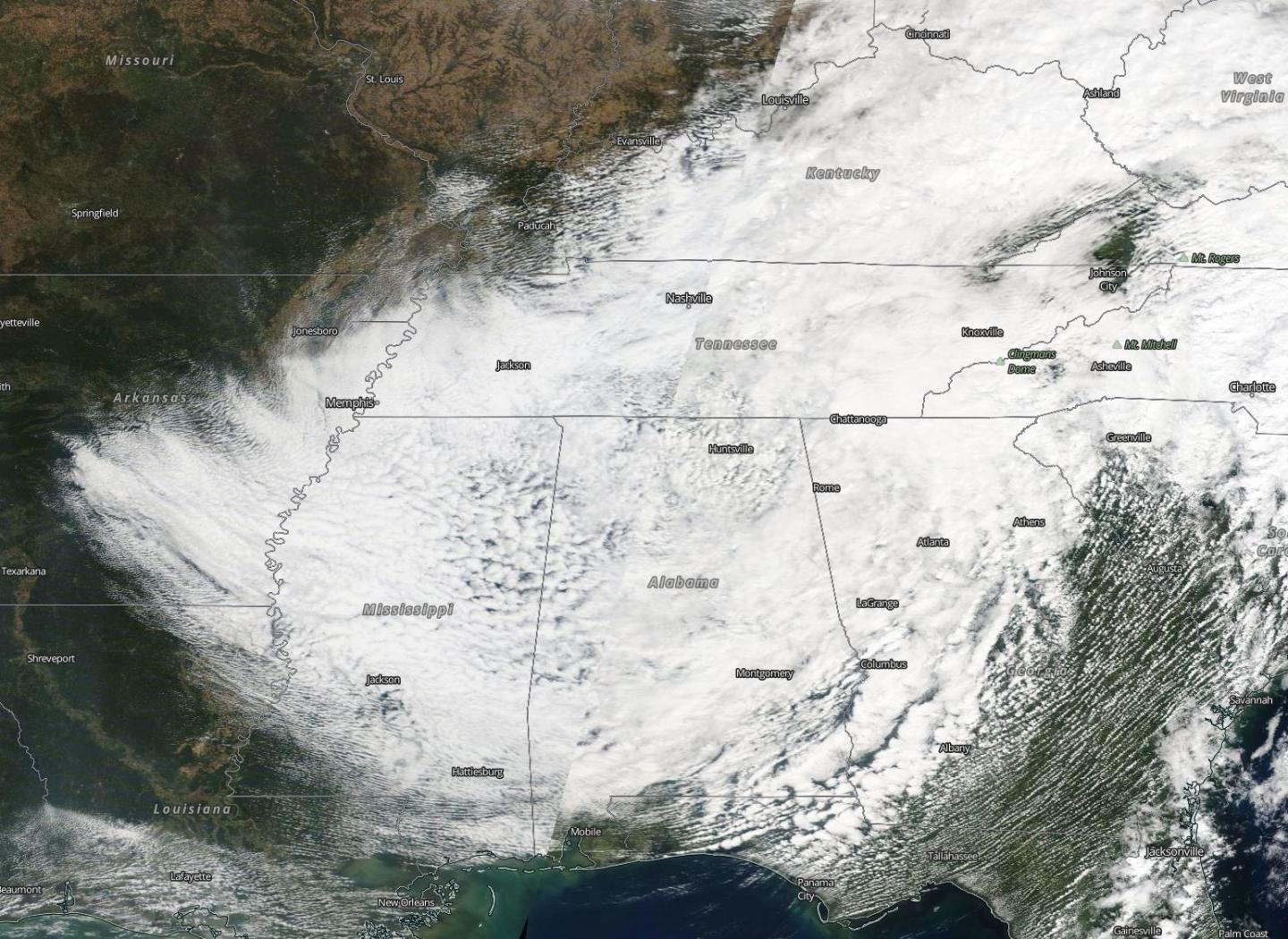
NASA Satellite View: Delta’s Organization

The Moderate Resolution Imaging Spectroradiometer or MODIS instrument that flies aboard NASA’s Terra satellite captured a visible image of Tropical Storm Delta on Oct. 11 at 1:30 p.m. EDT. The storm still appeared circular in imagery. At the time, it was centered over northern Alabama. At the time Terra passed overhead, Delta had weakened to a tropical depression with maximum sustained winds near 25 mph (35 kph).

Visible imagery from NASA’s Terra satellite captured from Oct. 9 to Oct. 12 were compiled into an animation. The animation showed the landfall and movement of Tropical Storm Delta. Delta dissipated over the southeastern U.S. and its remnants moved into the Atlantic states. The animation was created using NASA’s Worldview product at NASA’s Goddard Space Flight Center in Greenbelt, Md.

Delta’s Landfall on Oct. 9

National Weather Service Doppler radar imagery, Air Force Reserve Hurricane Hunter aircraft data, and surface observations indicated on Oct. 9 that Delta made landfall near Creole, Louisiana, around 7 p.m. EDT with estimated maximum sustained winds of 100 mph (155 kph).  Delta was a category 2 hurricane on the Saffir-Simpson Hurricane Wind Scale.

Delta’s Final Advisory

The National Hurricane Center (NHC) issued the final advisory on Delta at 11 p.m. EDT on Oct. 11 (Oct. 12 at 0300 UTC). At that time, the center of Post-Tropical Cyclone Delta was located near latitude 34.5 degrees north and longitude 84.1 degrees west. It was just 60 miles (95 km) north-northeast of Atlanta, Georgia. The post-tropical cyclone was moving toward the east near 15 mph. Maximum sustained winds were near 15 mph (30 kph) with higher gusts.

NHC said, “Some further weakening is possible tonight as a new surface low develops in the Carolinas, and Delta’s surface low is expected to be absorbed by this new low pressure area on Monday, Oct. 12.”

About NASA’s Worldview and Terra Satellite

NASA’s Earth Observing System Data and Information System (EOSDIS) Worldview application provides the capability to interactively browse over 700 global, full-resolution satellite imagery layers and then download the underlying data. Many of the available imagery layers are updated within three hours of observation, essentially showing the entire Earth as it looks “right now.”

NASA’s Terra satellite is one in a fleet of NASA satellites that provide data for hurricane research.

Tropical cyclones/hurricanes are the most powerful weather events on Earth. NASA’s expertise in space and scientific exploration contributes to essential services provided to the American people by other federal agencies, such as hurricane weather forecasting.

For updated forecasts, visit: http://www.nhc.noaa.gov

By Rob Gutro
NASA’s Goddard Space Flight Center

###

Media Contact
Rob Gutro
[email protected]

Original Source

https://blogs.nasa.gov/hurricanes/2020/10/13/delta-atlantic-ocean-7/

Tags: Atmospheric ChemistryAtmospheric ScienceClimate ChangeClimate ScienceEarth ScienceMeteorologyTechnology/Engineering/Computer ScienceTemperature-Dependent PhenomenaWeather/Storms
Share12Tweet8Share2ShareShareShare2

Related Posts

IMAGE

Scientists publish a blueprint to apply artificial intelligence to extend human longevity

January 27, 2021
IMAGE

In Brazil, many smaller dams disrupt fish more than large hydropower projects

January 27, 2021

New NCAR-Wyoming supercomputer to accelerate scientific discovery

January 27, 2021

Putting bugs on the menu, safely

January 27, 2021
Next Post
IMAGE

Physics professor recognized for pioneering research

IMAGE

Plant sciences student receives national honor

Leave a Reply Cancel reply

Your email address will not be published.

This site uses Akismet to reduce spam. Learn how your comment data is processed.

POPULAR NEWS

  • IMAGE

    The map of nuclear deformation takes the form of a mountain landscape

    54 shares
    Share 22 Tweet 14
  • People living with HIV face premature heart disease and barriers to care

    69 shares
    Share 28 Tweet 17
  • New drug form may help treat osteoporosis, calcium-related disorders

    41 shares
    Share 16 Tweet 10
  • New findings help explain how COVID-19 overpowers the immune system

    35 shares
    Share 14 Tweet 9

About

We bring you the latest biotechnology news from best research centers and universities around the world. Check our website.

Follow us

Tags

Chemistry/Physics/Materials SciencesInfectious/Emerging DiseasesGeneticsEcology/EnvironmentcancerTechnology/Engineering/Computer ScienceClimate ChangeMaterialsPublic HealthBiologyMedicine/HealthCell Biology

Recent Posts

  • Scientists publish a blueprint to apply artificial intelligence to extend human longevity
  • In Brazil, many smaller dams disrupt fish more than large hydropower projects
  • New NCAR-Wyoming supercomputer to accelerate scientific discovery
  • Putting bugs on the menu, safely
  • Contact Us

© 2019 Bioengineer.org - Biotechnology news by Science Magazine - Scienmag.

No Result
View All Result
  • Homepages
    • Home Page 1
    • Home Page 2
  • News
  • National
  • Business
  • Health
  • Lifestyle
  • Science

© 2019 Bioengineer.org - Biotechnology news by Science Magazine - Scienmag.

Welcome Back!

Login to your account below

Forgotten Password?

Create New Account!

Fill the forms below to register

All fields are required. Log In

Retrieve your password

Please enter your username or email address to reset your password.

Log In