Credit: Credit: NASA/NRL
NASA’s Aqua satellite gathered infrared imagery and cloud top temperature data on Tropical Depression Cristobal, and it revealed the heavy rainmaking capability of the storm.
The National Hurricane Center (NHC) forecasts Cristobal to track northward through the Gulf of Mexico and toward Louisiana’s coast. Watches and warnings have gone into effect.
On June 5, the NHC issued a Storm Surge Watch for the northern Gulf of Mexico coast from Indian Pass to Arepika, Florida, and from Grand Isle, Louisiana, to Ocean Springs, Mississippi, including Lake Borgne. In addition, a Tropical Storm Watch has been issued for the northern Gulf of Mexico coast from Intracoastal City Louisiana to the Alabama/Florida border, including Lake Pontchartrain and Lake Maurepas.
Infrared Imagery and Cloud Top Temperatures
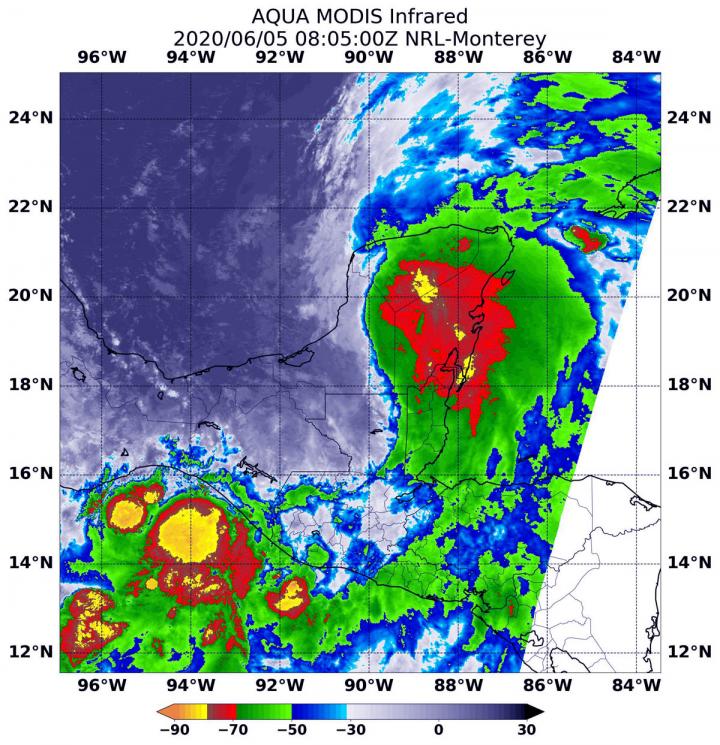
NASA’s Aqua satellite used infrared light to analyze the strength of storms in Cristobal. Infrared data provides temperature information, and the strongest thunderstorms that reach high into the atmosphere have the coldest cloud top temperatures. On June 5 at 4:05 a.m. EDT (0805 UTC), the Moderate Resolution Imaging Spectroradiometer or MODIS instrument aboard NASA’s Aqua satellite gathered temperature information about Cristobal’s cloud tops.
MODIS found several areas of powerful thunderstorms where temperatures were as cold as or colder than minus 70 degrees Fahrenheit (minus 56.6 Celsius). Cloud top temperatures that cold indicate strong storms with the potential to generate heavy rainfall. Those areas were located over Mexico’s Yucatan Peninsula, northeastern Guatemala, and out over the Eastern Pacific Ocean just off the coast of the Mexican states of Chiapas and Oaxaca.
NHC rainfall forecasts for Mexico’s Yucatan and Central America called for large quantities of rainfall. NHC noted of expected rainfall, “Mexican states of Campeche, Quintana Roo, and Yucatan…Additional 4 to 6 inches, isolated storm totals of 25 inches. Belize and the Mexican states of Tabasco and Oaxaca…Additional 4 to 6 inches, isolated storm totals of 12 inches. Southern Guatemala, coastal portions of Chiapas, and El Salvador…Additional 4 to 6 inches, isolated storm total amounts of 35 inches dating back to Saturday, May 30. Southern parts of Honduras…Additional 3 to 4 inches, isolated 8 inches.” Rainfall across Southeast Mexico and northern Central America would continue the risk of life-threatening flash floods and mudslides.
NHC forecasters said, as Cristobal moves north through the Gulf of Mexico, “Through Wednesday morning, for portions of the eastern and central Gulf Coast and the lower Mississippi Valley, rainfall accumulations of 4 to 8 inches, with local amounts to 12 inches, are forecast.”
Cristobal’s Status on June 6, 2020
The NHC said at 11 a.m. EDT (1500 UTC) on June 6, the center of Tropical Depression Cristobal was located near latitude 20.0 degrees north and longitude 89.9 degrees west. That puts the center about 40 miles (65 km) east of Campeche, Mexico. The depression was moving toward the north near 12 mph (19 kph), and this general motion is expected to continue for the next couple of days. The estimated minimum central pressure is 1000 millibars. Maximum sustained winds are near 35 mph (55 kph).
NHC Forecast for Cristobal
On the NHC forecast track, the center will move back over the southern Gulf of Mexico this evening, over the central Gulf of Mexico on Saturday, and be near the northern Gulf of Mexico coast Sunday evening. Some strengthening is forecast during the next 48 hours, and Cristobal is expected to regain tropical storm strength later today. Some additional strengthening is forecast thereafter.
Typhoons/hurricanes are the most powerful weather events on Earth. NASA’s expertise in space and scientific exploration contributes to essential services provided to the American people by other federal agencies, such as hurricane weather forecasting.
###
Fore updated forecasts, visit: http://www.
By Rob Gutro
NASA’s Goddard Space Flight Center
Media Contact
Rob Gutro
[email protected]
Original Source
https:/


