• HOME
  • NEWS
    • BIOENGINEERING
    • SCIENCE NEWS
  • EXPLORE
    • CAREER
      • Companies
      • Jobs
    • EVENTS
    • iGEM
      • News
      • Team
    • PHOTOS
    • VIDEO
    • WIKI
  • BLOG
  • COMMUNITY
    • FACEBOOK
    • FORUM
    • INSTAGRAM
    • TWITTER
  • CONTACT US
Friday, January 22, 2021
BIOENGINEER.ORG
No Result
View All Result
  • Login
  • HOME
  • NEWS
    • BIOENGINEERING
    • SCIENCE NEWS
  • EXPLORE
    • CAREER
      • Companies
      • Jobs
        • Lecturer
        • PhD Studentship
        • Postdoc
        • Research Assistant
    • EVENTS
    • iGEM
      • News
      • Team
    • PHOTOS
    • VIDEO
    • WIKI
  • BLOG
  • COMMUNITY
    • FACEBOOK
    • FORUM
    • INSTAGRAM
    • TWITTER
  • CONTACT US
No Result
View All Result
Bioengineer.org
No Result
View All Result
Home NEWS Science News

Infrared NASA imagery finds Chan-hom organizing, consolidating

Bioengineer by Bioengineer
October 6, 2020
in Science News
0
Share on FacebookShare on TwitterShare on LinkedinShare on RedditShare on Telegram

IMAGE

Credit: Credit: NASA JPL/Heidar Thrastarson

NASA’s Aqua satellite analyzed the large Tropical Storm Chan-hom as it tracked through the Northwestern Pacific Ocean. Aqua imagery showed the storm was consolidating, indicating a strengthening trend.

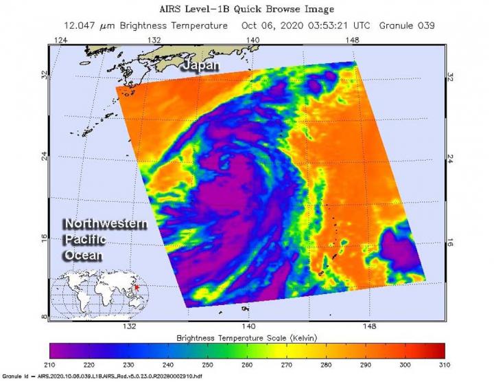
One of the ways NASA researches tropical cyclones is using infrared data that provides temperature information. The AIRS instrument aboard NASA’s Aqua satellite captured a look at those temperatures in Chan-hom and gave insight into the size of the storm and its rainfall potential.

Cloud top temperatures provide information to forecasters about where the strongest storms are located within a tropical cyclone. The stronger the storms, the higher they extend into the troposphere, and the colder the cloud top temperatures. NASA provides that data to forecasters at the Joint Typhoon Warning Center so they can incorporate it into their forecasting.

On Oct. 6 at 0353 UTC (Oct. 5 at 11:53 p.m. EDT) NASA’s Aqua satellite analyzed Tropical Storm Chan-hom using the Atmospheric Infrared Sounder or AIRS instrument. Forecasters at the Joint Typhoon Warning Center (JTWC) in Honolulu, Hawaii noted that animated enhanced infrared satellite imagery showed the system is consolidating.  JTWC noted there has been an improvement in the developing strong bands of thunderstorms wrapping into the low-level center.

AIRS found coldest cloud top temperatures as cold as or colder than minus 63 degrees Fahrenheit (minus 53 degrees Celsius) around the center of circulation. NASA research has shown that cloud top temperatures that cold indicate strong storms that have the capability to create heavy rain.

Despite the consolidation, a microwave image captured at 7:36 a.m. EDT (1136 UTC) indicated that the convective banding remains fragmented.

Chan-hom’s Status on Oct. 6

By 11 a.m. EDT (1500 UTC) on Oct. 6, Chan-hom was located near latitude 24.5 degrees north and longitude 137.2 degrees east. It is located approximately 552 nautical miles east-southeast of Kadena Air Base, Okinawa, Japan. It was moving to the west and had maximum sustained winds near 55 knots (63 mph/102 kph).

Chan-hom’s Forecast

Chan-hom is forecast to continue consolidating and organizing while it tracks generally to the northwest. It is expected to peak at typhoon strength in two days before weakening again.

###

About NASA’s AIRS Instrument

The AIRS instrument is one of six instruments flying on board NASA’s Aqua satellite, launched on May 4, 2002.

AIRS, in conjunction with the Advanced Microwave Sounding Unit (AMSU), senses emitted infrared and microwave radiation from Earth to provide a three-dimensional look at Earth’s weather and climate. Working in tandem, the two instruments make simultaneous observations down to Earth’s surface. With more than 2,000 channels sensing different regions of the atmosphere, the system creates a global, three-dimensional map of atmospheric temperature and humidity, cloud amounts and heights, greenhouse gas concentrations and many other atmospheric phenomena. Launched into Earth orbit in 2002, the AIRS and AMSU instruments fly aboard NASA’s Aqua spacecraft and are managed by NASA’s Jet Propulsion Laboratory in Southern California, under contract to NASA. JPL is a division of Caltech.

NASA Researches Tropical Cyclones

For more than five decades, NASA has used the vantage point of space to understand and explore our home planet, improve lives and safeguard our future. NASA brings together technology, science, and unique global Earth observations to provide societal benefits and strengthen our nation. Advancing knowledge of our home planet contributes directly to America’s leadership in space and scientific exploration.

More information about AIRS can be found at: https://airs.jpl.nasa.gov/

Media Contact
Rob Gutro
[email protected]

Original Source

https://blogs.nasa.gov/hurricanes/2020/10/06/chan-hom-northwestern-pacific-ocean-2/

Tags: Atmospheric ChemistryAtmospheric ScienceClimate ChangeClimate ScienceEarth ScienceMeteorologyTechnology/Engineering/Computer ScienceTemperature-Dependent PhenomenaWeather/Storms
Share12Tweet8Share2ShareShareShare2

Related Posts

IMAGE

New combination of immunotherapies shows great promise for treating lung cancer

January 22, 2021
IMAGE

Astronomers discover first cloudless, Jupiter-like planet

January 21, 2021

Advances in modeling and sensors can help farmers and insurers manage risk

January 21, 2021

Bringing atoms to a standstill: NIST miniaturizes laser cooling

January 21, 2021
Next Post
IMAGE

A timeline on the evolution of reptiles

IMAGE

California's August Complex largest fire in state's history

Leave a Reply Cancel reply

Your email address will not be published.

This site uses Akismet to reduce spam. Learn how your comment data is processed.

POPULAR NEWS

  • IMAGE

    The map of nuclear deformation takes the form of a mountain landscape

    54 shares
    Share 22 Tweet 14
  • People living with HIV face premature heart disease and barriers to care

    64 shares
    Share 26 Tweet 16
  • New drug form may help treat osteoporosis, calcium-related disorders

    40 shares
    Share 16 Tweet 10
  • New findings help explain how COVID-19 overpowers the immune system

    35 shares
    Share 14 Tweet 9

About

We bring you the latest biotechnology news from best research centers and universities around the world. Check our website.

Follow us

Tags

Climate ChangeEcology/EnvironmentMaterialsChemistry/Physics/Materials SciencesCell BiologyTechnology/Engineering/Computer ScienceBiologycancerGeneticsMedicine/HealthPublic HealthInfectious/Emerging Diseases

Recent Posts

  • New combination of immunotherapies shows great promise for treating lung cancer
  • Astronomers discover first cloudless, Jupiter-like planet
  • Advances in modeling and sensors can help farmers and insurers manage risk
  • Bringing atoms to a standstill: NIST miniaturizes laser cooling
  • Contact Us

© 2019 Bioengineer.org - Biotechnology news by Science Magazine - Scienmag.

No Result
View All Result
  • Homepages
    • Home Page 1
    • Home Page 2
  • News
  • National
  • Business
  • Health
  • Lifestyle
  • Science

© 2019 Bioengineer.org - Biotechnology news by Science Magazine - Scienmag.

Welcome Back!

Login to your account below

Forgotten Password?

Create New Account!

Fill the forms below to register

All fields are required. Log In

Retrieve your password

Please enter your username or email address to reset your password.

Log In