Agricultural films play a crucial role in enhancing crop productivity across various global ecosystems, being employed widely to promote efficiency in land use and resource management. However, the rapid proliferation of agricultural film usage comes with significant ecological implications that cannot be overlooked. The environmental impact of these films has prompted researchers and agronomists alike to prioritize comprehensive studies aimed at accurately mapping their distribution and utilization patterns. Such undertakings not only serve to facilitate strategic agricultural planning but also to conduct environmental impact assessments that can guide sustainable practices in the domain of agriculture.
In a recent breakthrough publication by a team from the Institute of Geographic Sciences and Natural Resources Research at the Chinese Academy of Sciences, a multifaceted approach to agricultural film mapping has been presented. The study employs advanced bibliometric analysis to trace the evolution of research dynamics surrounding agricultural film usage from 2000 to 2023. This timeline showcases a burgeoning interest in the field, highlighted by the exponential growth of publications tackling various aspects of agricultural film utilization. Researchers have been increasingly motivated to take a closer look at the implications of these materials through the lens of remote sensing technologies.
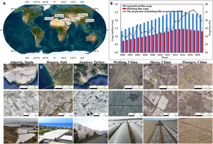
One of the study’s standout contributions lies in its visual representation of the evolution of remote sensing datasets, which have become indispensable in the mapping and monitoring of agricultural films across vast landscapes. High-resolution optical images, such as those captured by QuickBird and WorldView satellites, have been complemented by medium-resolution datasets from sources like Landsat and Sentinel-2. The integration of radar data, particularly from systems like Radarsat-2, further enriches the data landscape, allowing for robust analyses and enhanced reliability in agricultural film mapping.
Particularly noteworthy in this study is the investigation into the spectral-temporal-spatial characteristics of plastic greenhouses (PGs) and plastic-mulched farmland (PMF). The research team meticulously analyzed how the presence of agricultural films modifies the spectral signatures when viewed from remote sensing platforms. They found that the reflectance characteristics of PGs lie between those of impervious surfaces and vegetation, while PMFs present a mixed spectral signature due to their composition of both soil and mulching films. This nuanced understanding adds a layer of complexity to the methodologies employed in agricultural film mapping, suggesting that reliance on spectral features alone is inadequate for accurate identification.
The authors further delve into the interplay of environmental factors and the diverse types of agricultural films, elucidating how temporal and spatial variations can significantly influence mapping accuracy. By exploring object-based classification methods, their findings indicate a marked improvement in classification capabilities, especially when advanced algorithms like deep learning are harnessed in conjunction with high-resolution imagery. This aspect of technological integration reflects a broader trend in the field, where computational intelligence is leveraged to overcome traditional mapping challenges.
Additionally, the review stresses the critical future pathways for agricultural film mapping, emphasizing the necessity for developing methodologies that facilitate the integration of multi-source datasets. This call to action resonates strongly with the agricultural research community, highlighting the importance of creating expansive training datasets that encompass a wide variety of geographical contexts and agricultural practices. Expanding the diversity of sample datasets is vital for advancing machine learning efforts aimed at discerning the various types of agricultural films and their respective coverage periods.
The researchers also draw attention to the ongoing evolution of algorithms designed for agricultural film detection and mapping, recommending that future inquiries must prioritize the separation of different film types and the accurate extraction of coverage data. A framework that not only focuses on high-resolution captures but also emphasizes prolonged temporal datasets with reliable accuracy will provide key insights for better land use management and ecosystem protection.
The ambitious vision articulated by the research team extends to a collaborative call for global initiatives aimed at harmonizing datasets from diverse sources. Such endeavors hold the potential to push the boundaries of agricultural film mapping, thereby informing policy decisions critical to environmental sustainability. This synthesis of advancements paves the way for a comprehensive understanding of agricultural film dynamics, addressing not only current research gaps but also fostering innovative approaches to sustainable agriculture.
The implications of this study are profound, as well-timed and accurate agricultural film maps can transform land management practices. They hold the promise of enhancing our understanding of human land use behavior while providing critical data to guide policy formation focused on sustainable environmental practices. By charting the path forward with precision mapping of agricultural films, stakeholders are empowered to optimize resource allocations and minimize ecological footprints.
Ultimately, the discussions presented in this study resonate deeply with ongoing efforts to develop sustainable agriculture practices worldwide. The research contributes significantly to a growing body of literature that underscores the urgent need for rigorous methodologies to assess and mitigate the environmental impacts of agricultural film use. With collaborations poised to unify efforts across geographical and disciplinary borders, the future landscape of agricultural film mapping looks promising, both for scientific inquiry and practical agricultural applications.
Through this lens, the study not only captures the essence of agricultural film mapping as it stands today but also sets forth a clarion call for integrated approaches that prioritize both technological and ecological considerations. As the demand for increased productivity amidst ecological challenges continues to rise, the elevation of agricultural film research to the forefront of scientific discussions becomes an indispensable pursuit.
Subject of Research: Agricultural Film Mapping
Article Title: A Review of Agricultural Film Mapping: Current Status, Challenges, and Future Directions
News Publication Date: 30-Jan-2025
Web References: Journal of Remote Sensing
References: DOI: 10.34133/remotesensing.0395
Image Credits: Credit: Journal of Remote Sensing
Keywords: Sustainable agriculture, Agricultural Mapping, Remote Sensing, Environmental Impact, Agricultural Films
Tags: agricultural film mappingagricultural technology advancementsbibliometric analysis in agricultural researchchallenges in agricultural film usagecrop productivity enhancementecological implications of agricultural materialsenvironmental impact of agricultural filmsfuture opportunities in agricultural researchremote sensing in agricultureresource management in farmingstrategic agricultural planningsustainable agriculture practices


