Credit: NASA/NRL
Tropical Storm Paulette has run into wind shear that is pushing the bulk of clouds and showers away from its center of circulation, and that is apparent on infrared imagery from NASA.
A large upper-level trough or elongated area of low pressure is located to the northwest of Paulette, and this feature is producing 20 to 30 knots (23 to 35 mph/37 to 56 kph) of south-southwesterly wind shear over the cyclone. Wind shear occurs when winds blowing outside of a tropical cyclone at different levels of the atmosphere push against the tropical cyclone and can weaken it. The wind shear Paulette is experiencing is pushing the bulk of clouds to the north-northeast of the center.
NASA’s Infrared Data Reveals Heavy Rainmakers
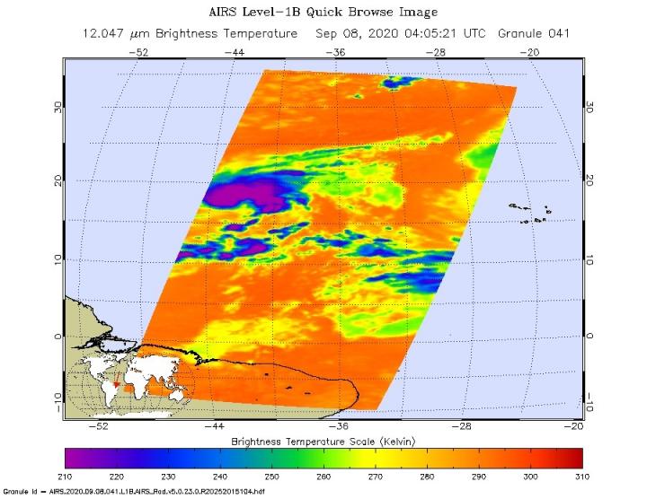
Tropical cyclones are made up of hundreds of thunderstorms, and infrared data can show where the strongest storms are located. That is because infrared data provides temperature information, and the strongest thunderstorms that reach highest into the atmosphere have the coldest cloud top temperatures.
On Sept. 9 at 12:50 a.m. EDT (0450 UTC), the Moderate Imaging Spectroradiometer or MODIS instrument that flies aboard NASA’s Aqua satellite used infrared light to analyze the strength of storms within Paulette. MODIS found the most powerful thunderstorms were near Paulette’s center where cloud top temperatures were as cold as minus 80 degrees Fahrenheit (minus 62.2 Celsius). However, strong storms with cloud top temperatures as cold as minus 70 degrees Fahrenheit (minus 56.6. degrees Celsius) were being pushed east-northeast of those most powerful storms. NASA research has found that cloud top temperatures that cold indicate strong storms with the potential to generate heavy rainfall.
Hurricane Specialist Robbie Berg of NOAA’s National Hurricane Center in Miami, Fla. noted, “Morning visible satellite images show that Paulette’s center is located beneath a thin veil of cirrus and displaced to the south of the deep convection.”
Paulette’s Status on Sept. 9
At 11 a.m. EDT (1500 UTC) on Sept. 9, the center of Tropical Storm Paulette was located near latitude 20.0 degrees north and longitude 46.5 degrees west. Paulette is 1,090 miles (1,755 km) east of the Northern Leeward Islands. Paulette is moving toward the west-northwest near 9 mph (15 kph). Maximum sustained winds are near 60 mph (95 kph) with higher gusts. The estimated minimum central pressure is 996 millibars.
Paulette’s Forecast from NHC
The NHC forecasts a general westward or west-northwestward motion through Friday, followed by a turn toward the northwest Friday night and Saturday. Some weakening is forecast during the next couple of days.
NHC said, “Swells generated by Paulette are expected to reach portions of the Leeward Islands Thursday night and Friday and will continue to spread westward to portions of the Greater Antilles, Bahamas, and Bermuda into the weekend. These swells are likely to cause life-threatening surf and rip current conditions.”
###
NASA Researches Earth from Space
For more than five decades, NASA has used the vantage point of space to understand and explore our home planet, improve lives and safeguard our future. NASA brings together technology, science, and unique global Earth observations to provide societal benefits and strengthen our nation. Advancing knowledge of our home planet contributes directly to America’s leadership in space and scientific exploration.
For updated forecasts, visit: http://www.
Rob Gutro
NASA’s Goddard Space Flight Center, Greenbelt, Md.
Media Contact
Rob Gutro
[email protected]
Original Source
https:/
