• HOME
  • NEWS
  • EXPLORE
    • CAREER
      • Companies
      • Jobs
    • EVENTS
    • iGEM
      • News
      • Team
    • PHOTOS
    • VIDEO
    • WIKI
  • BLOG
  • COMMUNITY
    • FACEBOOK
    • INSTAGRAM
    • TWITTER
Thursday, July 31, 2025
BIOENGINEER.ORG
No Result
View All Result
  • Login
  • HOME
  • NEWS
  • EXPLORE
    • CAREER
      • Companies
      • Jobs
        • Lecturer
        • PhD Studentship
        • Postdoc
        • Research Assistant
    • EVENTS
    • iGEM
      • News
      • Team
    • PHOTOS
    • VIDEO
    • WIKI
  • BLOG
  • COMMUNITY
    • FACEBOOK
    • INSTAGRAM
    • TWITTER
No Result
View All Result
Bioengineer.org
No Result
View All Result
Home NEWS Science News

NASA-NOAA satellite finds development of tropical cyclone 06A

Bioengineer by Bioengineer
December 3, 2019
in Science News
Reading Time: 2 mins read
0
Share on FacebookShare on TwitterShare on LinkedinShare on RedditShare on Telegram

IMAGE

Credit: Credit: NASA Worldview, Earth Observing System Data and Information System (EOSDIS)


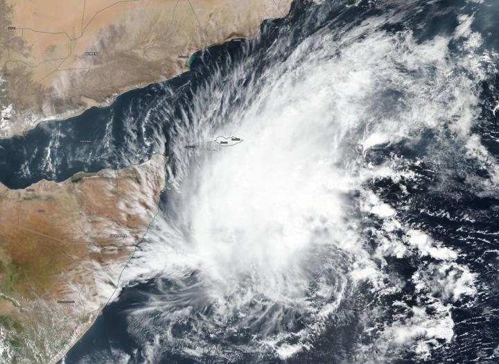
Imagery from NASA-NOAA’s Suomi NPP satellite showed that a tropical depression in the Arabian Sea has consolidated and organized despite facing wind shear. Tropical Depression 06A is now Tropical Cyclone 06A.

The Visible Infrared Imaging Radiometer Suite (VIIRS) instrument aboard Suomi NPP provided a visible image of 06A that revealed powerful storms were northwest of the center of circulation, but the storm was able to strengthen despite the harsh environmental conditions. The center of circulation is apparent in the VIIRS image as a small area of circulation located southeast of the bulk of clouds and showers.

In general, wind shear is a measure of how the speed and direction of winds change with altitude. Tropical cyclones are like rotating cylinders of winds. Each level needs to be stacked on top each other vertically in order for the storm to maintain strength or intensify. Wind shear occurs when winds at different levels of the atmosphere push against the rotating cylinder of winds, weakening the rotation by pushing it apart at different levels. In the case of Tropical Cyclone 06A, southeasterly winds are pushing the bulk of the storm’s clouds to the northwest.

The Joint Typhoon Warning Center or JTWC in Pearl Harbor, Hawaii noted, “A fully exposed low level circulation center in animated multispectral satellite imagery. Strong (20-30 knot/ 23 to 34.5 mph /32 to 55.5 kph) vertical wind shear is offsetting good poleward outflow and warm (28 to 29 degrees Celsius/82.4 to 84.2 degrees Fahrenheit) sea surface temperature, hampering intensification.” Tropical cyclones require sea surface temperatures of at least 26.6 degrees Celsius (80 degrees Fahrenheit) to maintain strength or intensify, so the warmer sea surface temperatures are allowing 06A to maintain its strength.

JTWC noted that at 10 a.m. EST (1500 UTC) on Dec. 3, that 06A had maximum sustained winds near 35 knots (40 mph/65 kph). 06A was located near latitude 7.1 degrees north and longitude 57.4 degrees east. It was about 784 nautical miles east-northeast of Mogadishu, Somalia.

It is moving to the northeast, however, and the track will slowly turn west southwestward as a subtropical ridge (elongated area of high pressure) builds back in to the north.

Tropical Cyclone 06A is forecast to make landfall in east central Somalia on Dec. 6 as a tropical storm.

Tropical cyclones and hurricanes are the most powerful weather events on Earth. NASA’s expertise in space and scientific exploration contributes to essential services provided to the American people by other federal agencies, such as hurricane weather forecasting.

###

By Rob Gutro 

NASA’s Goddard Space Flight Center

Media Contact
Rob Gutro
[email protected]

Original Source

https://blogs.nasa.gov/hurricanes/2019/12/03/06a-northern-indian-ocean/

Tags: Atmospheric ChemistryAtmospheric ScienceClimate ChangeClimate ScienceEarth ScienceMeteorologyTechnology/Engineering/Computer ScienceTemperature-Dependent PhenomenaWeather/Storms
Share12Tweet8Share2ShareShareShare2

Related Posts

Multiomics Uncovers Key Heart Failure Targets

Multiomics Uncovers Key Heart Failure Targets

July 31, 2025
blank

Standardizing Low-Dose Platelet Transfusions for Infants

July 31, 2025

α-Synuclein Fibril Structure Drives Parkinson’s Seeding

July 31, 2025

Not All Low-Grade Prostate Cancers Pose Low Risk, Study Finds

July 31, 2025
Please login to join discussion

POPULAR NEWS

  • Blind to the Burn

    Overlooked Dangers: Debunking Common Myths About Skin Cancer Risk in the U.S.

    60 shares
    Share 24 Tweet 15
  • Dr. Miriam Merad Honored with French Knighthood for Groundbreaking Contributions to Science and Medicine

    46 shares
    Share 18 Tweet 12
  • Study Reveals Beta-HPV Directly Causes Skin Cancer in Immunocompromised Individuals

    37 shares
    Share 15 Tweet 9
  • Engineered Cellular Communication Enhances CAR-T Therapy Effectiveness Against Glioblastoma

    35 shares
    Share 14 Tweet 9

About

We bring you the latest biotechnology news from best research centers and universities around the world. Check our website.

Follow us

Recent News

Multiomics Uncovers Key Heart Failure Targets

Standardizing Low-Dose Platelet Transfusions for Infants

α-Synuclein Fibril Structure Drives Parkinson’s Seeding

  • Contact Us

Bioengineer.org © Copyright 2023 All Rights Reserved.

Welcome Back!

Login to your account below

Forgotten Password?

Retrieve your password

Please enter your username or email address to reset your password.

Log In
No Result
View All Result
  • Homepages
    • Home Page 1
    • Home Page 2
  • News
  • National
  • Business
  • Health
  • Lifestyle
  • Science

Bioengineer.org © Copyright 2023 All Rights Reserved.