• HOME
  • NEWS
  • EXPLORE
    • CAREER
      • Companies
      • Jobs
    • EVENTS
    • iGEM
      • News
      • Team
    • PHOTOS
    • VIDEO
    • WIKI
  • BLOG
  • COMMUNITY
    • FACEBOOK
    • INSTAGRAM
    • TWITTER
Wednesday, July 23, 2025
BIOENGINEER.ORG
No Result
View All Result
  • Login
  • HOME
  • NEWS
  • EXPLORE
    • CAREER
      • Companies
      • Jobs
        • Lecturer
        • PhD Studentship
        • Postdoc
        • Research Assistant
    • EVENTS
    • iGEM
      • News
      • Team
    • PHOTOS
    • VIDEO
    • WIKI
  • BLOG
  • COMMUNITY
    • FACEBOOK
    • INSTAGRAM
    • TWITTER
No Result
View All Result
Bioengineer.org
No Result
View All Result
Home NEWS Science News Science

NASA-NOAA satellite analyzes Typhoon Wutip

Bioengineer by Bioengineer
February 22, 2019
in Science
Reading Time: 2 mins read
0
ADVERTISEMENT
Share on FacebookShare on TwitterShare on LinkedinShare on RedditShare on Telegram

IMAGE

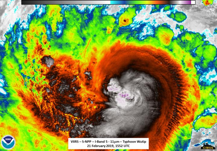
Credit: NASA/NOAA/Williams Straka III/UWM/CIMSS

Typhoon Wutip was impacting the Federated States of Micronesia in the Southern Pacific Ocean when NASA-NOAA’s Suomi NPP satellite passed overhead and analyzed the storm in infrared light.

On Feb. 22, the National Weather Service (NWS) in Tiyan, Guam noted that a Tropical Storm Warning remains in effect for Guam and Rota in the Mariana Islands and for Faraulep in Yap State. A Tropical Storm Watch also remains in effect for Tinian, Saipan, Pagan and Agrihan in the Commonwealth of the Northern Mariana Islands.

NASA-NOAA’s Suomi NPP satellite provided an infrared look at Typhoon Wutip on February 21 at 10:52 a.m. EDT (1552 UTC). William Straka III, of the University of Wisconsin-Madison, noted that the Visible Infrared Imaging Radiometer Suite (VIIRS) instrument aboard found Suomi NPP showed an intense cold region in the exact location of the overshooting cloud top observed in infrared, which just happens to be where the lightning streak was observed in other satellite imagery. In addition, it seemed to indicate some wrapping of the colder cloud regions around the inner circulation.

VIIRS showed storms around the center were as cold as or colder than 70 degrees (red) Fahrenheit (minus 56.6 degrees Celsius). NASA research has found that cloud top temperatures as cold as or colder than the 70F/56.6C threshold have the capability to generate heavy rainfall.

At 10 a.m. EDT/1500 UTC on Feb. 22 (1 a.m. CHST local time, Feb. 23) the eye of Typhoon Wutip was located by satellite at Latitude 10.1 degrees North and Longitude 144.7 degrees East and moving northwest at 15 mph. That’s about 105 miles north of Faraulep and about 230 miles south of Guam.

Wutip is expected to continue on a northwest track today and tonight with decreasing forward speed, then turn to a north-northwest course on Sunday and Monday. This track takes Wutip to a closest approach of about 160 miles southwest of Guam this evening. Maximum sustained winds have increased to 120 mph. Wutip is expected to maintain this intensity today, then begin a slow weakening trend tonight and Sunday.

Typhoon force winds extend outward up to 45 miles from the center, and tropical storm force winds extend out up to 185 miles.

The Joint Typhoon Warning Center forecast said Wutip will continue to track northwestward through February 24, before turning more north.

###

For updated forecasts, visit: https://www.prh.noaa.gov/guam/cyclone.php

By Rob Gutro

NASA’s Goddard Space Flight Center

Media Contact
Rob Gutro
[email protected]

Original Source

https://blogs.nasa.gov/hurricanes/tag/wutip-2019/

Tags: Atmospheric ChemistryAtmospheric ScienceClimate ChangeClimate ScienceEarth ScienceMeteorologyTechnology/Engineering/Computer ScienceTemperature-Dependent PhenomenaWeather/Storms
Share12Tweet8Share2ShareShareShare2

Related Posts

Five or more hours of smartphone usage per day may increase obesity

July 25, 2019
IMAGE

NASA’s terra satellite finds tropical storm 07W’s strength on the side

July 25, 2019

NASA finds one burst of energy in weakening Depression Dalila

July 25, 2019

Researcher’s innovative flood mapping helps water and emergency management officials

July 25, 2019
Please login to join discussion

POPULAR NEWS

  • Blind to the Burn

    Overlooked Dangers: Debunking Common Myths About Skin Cancer Risk in the U.S.

    58 shares
    Share 23 Tweet 15
  • New Organic Photoredox Catalysis System Boosts Efficiency, Drawing Inspiration from Photosynthesis

    54 shares
    Share 22 Tweet 14
  • IIT Researchers Unveil Flying Humanoid Robot: A Breakthrough in Robotics

    53 shares
    Share 21 Tweet 13
  • AI Achieves Breakthrough in Drug Discovery by Tackling the True Complexity of Aging

    70 shares
    Share 28 Tweet 18

About

We bring you the latest biotechnology news from best research centers and universities around the world. Check our website.

Follow us

Recent News

Additive Manufacturing of Monolithic Gyroidal Solid Oxide Cells

Machine Learning Uncovers Sorghum’s Complex Mold Resistance

Pathology Multiplexing Revolutionizes Disease Mapping

  • Contact Us

Bioengineer.org © Copyright 2023 All Rights Reserved.

Welcome Back!

Login to your account below

Forgotten Password?

Retrieve your password

Please enter your username or email address to reset your password.

Log In
No Result
View All Result
  • Homepages
    • Home Page 1
    • Home Page 2
  • News
  • National
  • Business
  • Health
  • Lifestyle
  • Science

Bioengineer.org © Copyright 2023 All Rights Reserved.