Credit: Credit: NASA/NRL
Tropical Depression 8E developed on July 20 and quickly organized into a tropical storm. Infrared NASA satellite imagery revealed that Tropical Storm Douglas contained strong storms and showed banding of thunderstorms around its center.
Tropical Depression 8E formed about 905 miles (1,460 km) southwest of the southern tip of Baja California, Mexico by 11 a.m. EDT on July 20. Within 12 hours, 8E had strengthened into a tropical storm and was renamed Douglas.
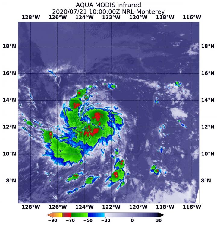
On July 21 at 6 a.m. a.m. EDT (1000 UTC), the Moderate Resolution Imaging Spectroradiometer or MODIS instrument aboard NASA’s Aqua satellite analyzed Douglas’ cloud tops in infrared light. Infrared data provides temperature information, and the strongest thunderstorms that reach high into the atmosphere have the coldest cloud top temperatures.
The National Hurricane Center (NHC) noted that Douglas’ center is also now embedded beneath a central dense overcast (a large central area of thunderstorms surrounding its circulation center) in infrared imagery, near an area of cold overshooting cloud tops. Aqua found several areas of strong storms around the center of Douglas’ circulation and in broken bands of thunderstorms wrapping into that low-level center. In those areas, temperatures were as cold as or colder than minus 70 degrees Fahrenheit (minus 56.6 Celsius). Cloud top temperatures that cold indicate strong storms with the potential to generate heavy rainfall.
At 10 a.m. EDT (1500 UTC), the center of Tropical Storm Douglas was located near latitude 12.4 degrees north and longitude 124.2 degrees west. About 2,110 miles (3,390 km) east of Hilo, Hawaii.
Maximum sustained winds have increased to near 65 mph (100 kph) with higher gusts.
The estimated minimum central pressure is 998 millibars. Douglas is moving toward the west-southwest near 15 mph (24 kph). A turn toward the west at a similar forward speed is expected later today, followed by a turn toward the west-northwest Wednesday night (July 22).
NHC forecaster Robbie Berg said, “The low-[wind]shear, warm sea surface temperature environment within which Douglas is moving is a recipe for continued strengthening, potentially at a rapid rate, for the next 48 hours.”
Additional strengthening is forecast during the next several days, and Douglas could become a hurricane later today.
Tropical cyclones/hurricanes are the most powerful weather events on Earth. NASA’s expertise in space and scientific exploration contributes to essential services provided to the American people by other federal agencies, such as hurricane weather forecasting.
For updated forecasts, visit: http://www.
###
Media Contact
Rob Gutro
[email protected]
Original Source
https:/


