• HOME
  • NEWS
  • EXPLORE
    • CAREER
      • Companies
      • Jobs
    • EVENTS
    • iGEM
      • News
      • Team
    • PHOTOS
    • VIDEO
    • WIKI
  • BLOG
  • COMMUNITY
    • FACEBOOK
    • INSTAGRAM
    • TWITTER
Thursday, August 21, 2025
BIOENGINEER.ORG
No Result
View All Result
  • Login
  • HOME
  • NEWS
  • EXPLORE
    • CAREER
      • Companies
      • Jobs
        • Lecturer
        • PhD Studentship
        • Postdoc
        • Research Assistant
    • EVENTS
    • iGEM
      • News
      • Team
    • PHOTOS
    • VIDEO
    • WIKI
  • BLOG
  • COMMUNITY
    • FACEBOOK
    • INSTAGRAM
    • TWITTER
No Result
View All Result
Bioengineer.org
No Result
View All Result
Home NEWS Science News Chemistry

Solving the salt problem for seismic imaging

Bioengineer by Bioengineer
July 22, 2019
in Chemistry
Reading Time: 2 mins read
0
Share on FacebookShare on TwitterShare on LinkedinShare on RedditShare on Telegram

IMAGE

Credit: © 2019 Mahesh Kalita

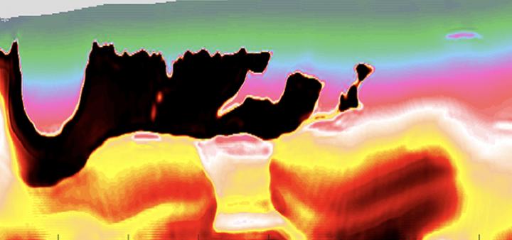
The efficient extraction of oil and gas from within the Earth’s crust requires accurate images of subsurface rock structures. Some materials are hard to capture, so KAUST researchers have developed a computational method for modeling large accumulations of subsurface salt, a challenging material to derive accurately from seismic imaging data.

Seismic imaging involves sending soundwaves into the ground, where they will be reflected at boundaries between rock structures. Scientists analyze the reflected soundwaves to determine subsurface rock types and formations, and to pinpoint fossil fuel reservoirs.

However, in some regions, such as the Gulf of Mexico, the subsurface is peppered with salt bodies, which are huge accumulations of salt formed millions of years ago deep inside the Earth. Salt is a low-density, buoyant substance, meaning that salt bodies gradually rise through the Earth’s crust over time. This causes stress-related complexities between the salt and the surrounding rock layers. Furthermore, the salt’s crystal structure means that soundwaves are reflected at random, and there are no useable low frequencies retained in the seismic data.

“Data from salt zones are presently analyzed by highly trained experts rather than modeled by a computer,” explains Mahesh Kalita, a KAUST Ph.D. student in Tariq Alkhalifah’s group. “This is a time-consuming and expensive process that carries the risk of human error. We’ve developed a robust computational method for interpreting seismic data from salt bodies quickly and more accurately.”

Existing models use a technique called full waveform inversion (FWI) to minimize the disparity between observed and modeled data. However, the lack of low frequencies in soundwave data from salt bodies means that a traditional FWI fails. Kalita and the team developed a two-part optimization process to refine FWI for salt body imaging.

“For the topmost layer of salt, we get a good enough signal to determine where the salt body begins, but then the soundwave energy rapidly disperses,” says Kalita. “Our technique takes the initial data from this top layer and ‘smears’ it across the most likely area that the salt body encompasses. We call this technique ‘flooding’.”

The resulting model is then tested alongside observed data to check that the surrounding rock structures match up and to ensure the model has not been “over-flooded.” Initial trials using a 1990s dataset from the Gulf of Mexico showed promise, with the new technique generating an accurate representation of local salt bodies.

“We will next trial our automated technique on recent, high-quality datasets that incorporate more three-dimensional details,” says Kalita.

###

Media Contact
Carolyn Unck
[email protected]

Original Source

https://discovery.kaust.edu.sa/en/article/855/solving-the-salt-problem-for-seismic-imaging

Related Journal Article

http://dx.doi.org/10.1190/geo2018-0146.1

Tags: Civil EngineeringEarth ScienceGeographyGeology/SoilGeophysics/Gravity
Share12Tweet8Share2ShareShareShare2

Related Posts

blank

Innovative Research Paves the Way for Greener, Faster Metal Production

August 21, 2025
Scientists Harness Electrochemistry to Enhance Nuclear Fusion Rates

Scientists Harness Electrochemistry to Enhance Nuclear Fusion Rates

August 21, 2025

Groundbreaking Supernova Discovery Unveils the Inner Secrets of a Dying Star

August 21, 2025

New “In and Out” Mechanism Uncovers How Carbon Dioxide Interacts with Water’s Surface

August 20, 2025
Please login to join discussion

POPULAR NEWS

  • blank

    Molecules in Focus: Capturing the Timeless Dance of Particles

    141 shares
    Share 56 Tweet 35
  • Neuropsychiatric Risks Linked to COVID-19 Revealed

    81 shares
    Share 32 Tweet 20
  • Modified DASH Diet Reduces Blood Sugar Levels in Adults with Type 2 Diabetes, Clinical Trial Finds

    60 shares
    Share 24 Tweet 15
  • Predicting Colorectal Cancer Using Lifestyle Factors

    47 shares
    Share 19 Tweet 12

About

We bring you the latest biotechnology news from best research centers and universities around the world. Check our website.

Follow us

Recent News

Proximity Screening Boosts Graphene’s Electronic Quality

Revolutionary Laser Technique Simplifies Production of High-Performance Alloy Films

New Study Reveals 40% Decline in Leisure Reading Over Two Decades

  • Contact Us

Bioengineer.org © Copyright 2023 All Rights Reserved.

Welcome Back!

Login to your account below

Forgotten Password?

Retrieve your password

Please enter your username or email address to reset your password.

Log In
No Result
View All Result
  • Homepages
    • Home Page 1
    • Home Page 2
  • News
  • National
  • Business
  • Health
  • Lifestyle
  • Science

Bioengineer.org © Copyright 2023 All Rights Reserved.