• HOME
  • NEWS
  • EXPLORE
    • CAREER
      • Companies
      • Jobs
    • EVENTS
    • iGEM
      • News
      • Team
    • PHOTOS
    • VIDEO
    • WIKI
  • BLOG
  • COMMUNITY
    • FACEBOOK
    • INSTAGRAM
    • TWITTER
Sunday, July 27, 2025
BIOENGINEER.ORG
No Result
View All Result
  • Login
  • HOME
  • NEWS
  • EXPLORE
    • CAREER
      • Companies
      • Jobs
        • Lecturer
        • PhD Studentship
        • Postdoc
        • Research Assistant
    • EVENTS
    • iGEM
      • News
      • Team
    • PHOTOS
    • VIDEO
    • WIKI
  • BLOG
  • COMMUNITY
    • FACEBOOK
    • INSTAGRAM
    • TWITTER
No Result
View All Result
Bioengineer.org
No Result
View All Result
Home NEWS Science News Science

Satellite finds Tropical Cyclone Joaninha slammed by wind shear

Bioengineer by Bioengineer
March 29, 2019
in Science
Reading Time: 2 mins read
0
ADVERTISEMENT
Share on FacebookShare on TwitterShare on LinkedinShare on RedditShare on Telegram

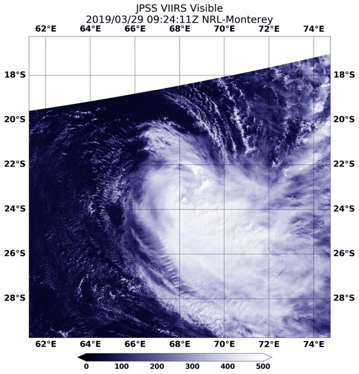
IMAGE

Credit: Credit: NOAA/NRL

One day makes a big difference when you’re a tropical cyclone. On March 28, Tropical Cyclone Joaninha still maintained an eye, and on March 29, once outside winds ramped up, the storm weakened quickly. NOAA’s NOAA-20 satellite provided an image of the storm that showed a large area of thunderstorms were pushed away from the center.

On March 29, 2019 at 11 a.m. EDT (1500 UTC), Joaninha’s maximum sustained winds dropped to 65 knots. It was centered near 23.6 degrees south latitude and 68.6 degrees east longitude. That’s approximately 655 nautical miles east-southeast of Port Louis, Mauritius. Joaninha was moving to the southeast.

When NOAA’s NASA-20 satellite passed over Tropical Cyclone Joaninha on March 29 at 5:24 a.m. EDT (0924 UTC) the VIIRS instrument aboard captured a visible image of the storm. Satellite imagery showed struggling central deep convection (rising air that condenses into clouds and thunderstorms that make up a tropical cyclone) being pushed away from the low level circulation center to the east.

In general, wind shear is a measure of how the speed and direction of winds change with altitude. Tropical cyclones are like rotating cylinders of winds. Each level needs to be stacked on top each other vertically in order for the storm to maintain strength or intensify. Wind shear occurs when winds at different levels of the atmosphere push against the rotating cylinder of winds, weakening the rotation by pushing it apart at different levels.

Increasing westerly vertical wind shear above 30 knots continues to affect the system’s structure, leading to rapid weakening. That wind shear is forecast to increase, according to the Joint Typhoon Warning Center or JTWC. In addition, Joaninha is expected to move into sea surface temperatures cooler than the 80 degree Fahrenheit (26.6 degree Celsius) threshold needed to maintain a storm. Between the increasing wind shear and cooler waters, Joaninha is expected to continue to weaken.

JTWC also noted that within three days, “the cyclone will begin to transition from a tropical to subtropical storm with expansive, asymmetric, gale force wind radii as it merges with a cutoff low pressure area.”

###

Media Contact
Rob Gutro
[email protected]

Original Source

https://blogs.nasa.gov/hurricanes/tag/joaninha-2019/

Tags: Atmospheric ChemistryAtmospheric ScienceClimate ChangeClimate ScienceEarth ScienceMeteorologyTechnology/Engineering/Computer ScienceTemperature-Dependent PhenomenaWeather/Storms
Share12Tweet8Share2ShareShareShare2

Related Posts

Five or more hours of smartphone usage per day may increase obesity

July 25, 2019
IMAGE

NASA’s terra satellite finds tropical storm 07W’s strength on the side

July 25, 2019

NASA finds one burst of energy in weakening Depression Dalila

July 25, 2019

Researcher’s innovative flood mapping helps water and emergency management officials

July 25, 2019
Please login to join discussion

POPULAR NEWS

  • Blind to the Burn

    Overlooked Dangers: Debunking Common Myths About Skin Cancer Risk in the U.S.

    50 shares
    Share 20 Tweet 13
  • USF Research Unveils AI Technology for Detecting Early PTSD Indicators in Youth Through Facial Analysis

    42 shares
    Share 17 Tweet 11
  • Dr. Miriam Merad Honored with French Knighthood for Groundbreaking Contributions to Science and Medicine

    45 shares
    Share 18 Tweet 11
  • New Measurements Elevate Hubble Tension to a Critical Crisis

    43 shares
    Share 17 Tweet 11

About

We bring you the latest biotechnology news from best research centers and universities around the world. Check our website.

Follow us

Recent News

Durable, Flexible Electrochemical Transistors via Electropolymerized PEDOT

Challenges and Opportunities in High-Filled Polymer Manufacturing

Epicardial Fat: Protector or Threat to Heart Health?

  • Contact Us

Bioengineer.org © Copyright 2023 All Rights Reserved.

Welcome Back!

Login to your account below

Forgotten Password?

Retrieve your password

Please enter your username or email address to reset your password.

Log In
No Result
View All Result
  • Homepages
    • Home Page 1
    • Home Page 2
  • News
  • National
  • Business
  • Health
  • Lifestyle
  • Science

Bioengineer.org © Copyright 2023 All Rights Reserved.