Credit: NASA/NOAA/UWM-CIMSS, William Straka III
NASA-NOAA’s Suomi NPP satellite and NASA’s Aqua satellite both passed over the Northwestern Pacific Ocean and both used infrared light to obtain temperature data and shape information on Typhoon Bualoi.
The shape of a storm says a lot about what is happening to it. Symmetrical storms are stronger, more organized storms. It is like a spinning tire that is well rounded. It can spin faster. Asymmetric storms cannot rotate as fast as symmetrical storms. It is similar to a flat tire cannot go as fast as a rounded tire. Satellite data provides a look at the symmetry of storms and found that Typhoon Bualoi is now an asymmetric storm, indicating it is weakening.
Infrared data provides temperature information, and the strongest thunderstorms that reach high into the atmosphere have the coldest cloud top temperatures. This data is helpful to forecasters because storms are not uniform around tropical cyclones and it helps pinpoint where the strongest storms are located.
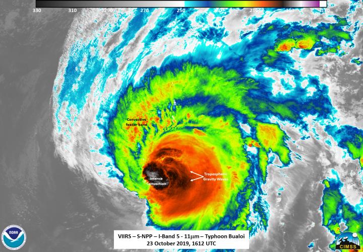
On Oct. 23 at 12:12 p.m. EDT (1612 UTC), the Visible Infrared Imaging Radiometer Suite (VIIRS) instrument aboard Suomi NPP found strongest thunderstorms west of center had cloud top temperatures as cold as 190 Kelvin (minus 117 degrees Fahrenheit/minus 83.1 Celsius). NASA research has shown that cloud top temperatures that cold indicate strong storms have the potential to generate heavy rainfall.
William Straka III, a researcher at the University of Wisconsin – Madison, Space Science and Engineering Center (SSEC) created imagery of the storm using the Suomi-NPP satellite. The strongest thunderstorms were on the western side of the eye, while the eastern side showed tropospheric gravity waves created by overshooting cloud tops into the stratosphere. An overshooting cloud top is a dome-like protrusion above a cumulonimbus anvil cloud, often penetrating into the lower stratosphere. It indicates a very strong updraft in the convective cloud or thunderstorm.
Gravity waves are the mark of a powerful storm. They are created when air moving around the atmosphere gets pushed to another place as in the case of tropical cyclones. Powerful thunderstorms around a tropical cyclone’s center can move air up and down and generate these waves in quick, short bursts. They can be seen as ripples in some imagery of clouds in a tropical cyclone.
“The brightness temperature showed an asymmetrical orientation with the circulation being hidden in the convection. Also, the southern part of the storm seems to have some dry air intruding in on it, simply based on the infrared appearance,” Straka said.
When NASA’s Aqua satellite passed over Typhoon Bualoi, the Atmospheric Infrared Sounder or AIRS instrument aboard captured an image of the storm on Oct. 23 at 11:29 p.m. EDT (0329 UTC). Aqua found that the strongest thunderstorms around west of center had cloud top temperatures as cold as or colder than 210 Kelvin (minus 81.6 degrees Fahrenheit/minus 63.5 Celsius). The Joint Typhoon Warning Center said that animated enhanced infrared satellite imagery depicts decaying deep convective banding wrapping into a ragged eye.
On Oct. 24 at 11 a.m. EDT (1500 UTC), Typhoon Bualoi was located near latitude 29.4 degrees north and longitude 143.5 degrees east. That is about 670 nautical miles south of Misawa, Japan. Bualoi was moving to the north-northeast with maximum sustained winds near 90 knots (103 mph/167 kph).
The Joint Typhoon Warning Center noted that Bualoi is moving north-northeast and will continue to weaken. The storm will become extra-tropical east of Japan within 24 hours.
###
Hurricanes are the most powerful weather event on Earth. NASA’s expertise in space and scientific exploration contributes to essential services provided to the American people by other federal agencies, such as hurricane weather forecasting.
By Rob Gutro
NASA’s Goddard Space Flight Center
Media Contact
Rob Gutro
[email protected]
Original Source
https:/


