
As climate change accelerates the intensity and frequency of extreme weather events, particularly flooding, there is an urgent need for effective flood mitigation strategies. Recent research from the University of Vermont (UVM) underscores the critical role that floodplains—natural low-lying areas adjacent to rivers and streams—play in reducing the impact of floods on communities, agriculture, and essential infrastructure. As front-line defenses against rising water, floodplains serve as temporary storage zones for floodwaters, which can significantly diminish both flood peaks and erosional damage in a process known as attenuation.
Floodplains contribute to the overall health of river ecosystems by moderating how water flows across landscapes during flood events. This natural buffering process is essential for protecting lives and property in downstream communities. However, the effectiveness of floodplains is not uniform; recent findings from UVM indicate that various topographic features significantly influence a floodplain’s ability to mitigate flood impacts. This understanding raises important questions about how flood mitigation efforts are designed, prioritized, and implemented at local, regional, and national levels.
The findings of the UVM study have been published in the esteemed Journal of Geophysical Research: Earth Surface, presenting a novel classification system that identifies and characterizes different types of floodplains based on their capabilities to attenuate floodwaters. According to Dr. Rebecca Diehl, the study’s lead researcher, the new classification method facilitates a broader assessment of floodplain functions across various landscapes and will be integral to enhancing flood resilience strategies nationwide. Despite their importance, floodplains have often been overlooked in large-scale water resource assessments, including flood prediction models.
Using readily available topographic data sets, the researchers were able to uncover distinct features along riverbanks that could effectively slow floodwaters more than adjacent areas. The identification and classification of these features enabled the study to demonstrate the relationship between topography and flood mitigation potential. The research team’s rigorous evaluation revealed notable differences among the various floodplain types, emphasizing that understanding these distinctions is crucial for effective flood routing and management.
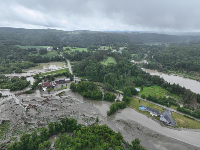
One area where the research was specifically illustrated is the Lake Champlain Basin in Vermont, where elevations range dramatically from the peaks of the Green and Taconic Mountains down to the lowlands of the Champlain and Hudson Valleys. The researchers characterized six unique types of floodplains in this region, each contributing differently to flood attenuation. By systematically classifying these diverse floodplain types, the study introduces a significant advancement in the understanding of flood dynamics, suggesting that geography and landscape play pivotal roles in flood routing processes.
The Hydraulic Floodplain Classification proposed by the UVM team presents an adaptable framework, which can be utilized for water resource assessments and floodplain management across various regions and watersheds. This is an important step towards developing data-driven flood resilience projects that can systematically target floodplain reconnection efforts, removal of obsolete infrastructure, and replanting of riparian zones. Prioritizing floodplain restoration and conservation based on scientific assessments fosters a more sustainable approach to managing flood risks.
By pinpointing the floodplains that are most effective at slowing floodwaters, this research serves as a critical resource for watershed management and restoration initiatives. It highlights which topographical attributes are most vital for flood attenuation, thus informing decision-making by land managers and policymakers. A robust classification system can simplify the identification of naturally attenuating floodplain features, aiding in the formulation of flood resilience plans that leverage natural landscapes’ functions.
The implications of this research extend beyond mere flood management; they underline the necessity of maintaining natural landscapes in the face of escalating climate challenges. Enhanced knowledge of how floodplains operate can refine flood forecasting methodologies, ultimately leading to more accurate and timely warnings. Inadequate flood modeling often results in miscalculations that jeopardize lives and property, making the accurate representation of wetlands and floodplains essential for effective risk management.
The Hydraulic Floodplain Classification is not just a theoretical exercise; it carries practical applications that can transform flood forecasting techniques and improve community preparedness. Recognizing the distinctive hydraulic characteristics of different floodplain types allows for the development of more effective models, ensuring better predictions of streamflow and flood inundation. As communities increasingly confront the realities of climate change, this research embodies a proactive approach that prioritizes increased resilience through a deeper understanding of natural systems.
Additionally, the preservation of floodplains becomes even more imperative as the frequency and intensity of extreme weather events rise. Not only do floodplains act as buffers against the harmful impacts of flooding, but they also contribute to the overall health of freshwater ecosystems by facilitating the deposition and retention of sediments, nutrients, and pollutants. This multifaceted role underscores the significance of natural floodplain systems in fostering improved water quality alongside flood resilience.
As the urgency for thoughtful, data-driven flood management amplifies, tools like the Hydraulic Floodplain Classification will be invaluable. They represent a merging of empirical research with practical application, providing communities with the insights needed to craft effective flood resilience strategies. Ultimately, by harnessing natural features and understanding their roles within a river ecosystem, floodplain management can become a core component of disaster preparedness initiatives in a changing climate.
With this innovative approach, a paradigm shift is on the horizon in terms of how flood management strategies are devised, implemented, and understood. Research that elucidates the relationships between topography and flood mitigation capabilities is essential for equitable and informed stewardship of natural resources. The findings from UVM contribute not just to the academic discourse but have far-reaching implications for community resilience, environmental sustainability, and the future of flood risk management in an era characterized by uncertainty.
Understanding the intricate connections between floodplains, topography, and climate change resilience can pave the way for comprehensive flood management plans aimed at safeguarding both human and ecological communities. This research stands as a reminder of the urgent need to take proactive measures to address the looming challenges posed by climate change and extreme weather, setting a focal point for future inquiries into sustainable practices for flood management.
Subject of Research: Floodplain dynamics and their impact on flood mitigation
Article Title: Identifying Hydraulically Distinct Floodplain Types From High Resolution Topography With Implications for Broad-Scale Flood Routing
News Publication Date: 9-Apr-2025
Web References: https://agupubs.onlinelibrary.wiley.com/doi/10.1029/2024JF007984
References: DOI 10.1029/2024JF007984
Image Credits: Photo by Vermont Agency of Transportation
Keywords: floods, climate change mitigation, floodplain management, freshwater ecology, watersheds, topography, flood resilience, flood forecasting.
Tags: agricultural flood risk reductionclimate change impacts on floodingcommunity flood protection measureseffective flood management approachesflood attenuation processesflood mitigation strategiesfloodplain classification methodsJournal of Geophysical Research publicationsnatural disaster resilienceriver ecosystem healthtopographic influence on floodplainsUVM floodplain research findings


