
Researchers at Heriot-Watt University, alongside various esteemed institutions, have unveiled a groundbreaking advancement in LiDAR technology that stands to reshape the future of 3D imaging. Their innovative single-photon time-of-flight LiDAR system represents a significant leap forward, enabling the detailed capture of high-resolution images from distances of up to one kilometer. This technological marvel not only enhances security and monitoring capabilities but also promises to redefine our understanding of environmental imaging, particularly in challenging conditions where traditional cameras might fail.
The core of this revolutionary system is its adoption of a highly efficient single-photon detector, which is reported to be twice as efficient as those currently employed in similar LiDAR configurations. Aongus McCarthy, a member of the research team at Heriot-Watt University, articulated the importance of these advancements, noting that the improved timing resolution—at least ten times better than previous models—allows for the collection of a greater number of scattered photons. Consequently, this capability leads to images that are not just clearer but also richer in detail.
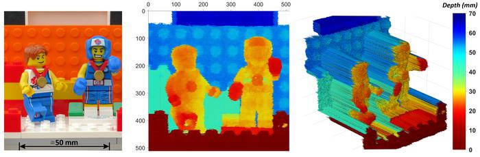
In a study published in the journal Optica, which is renowned for high-impact research, the multi-institutional research group illustrated the system’s capabilities through various impressive field tests. One notable experiment showcased the technology’s ability to construct a recognizable 3D image of a human face from a staggering distance of 325 meters. This feat was achieved by a collaborative effort of scholars from Heriot-Watt University, the University of Glasgow, the NASA Jet Propulsion Laboratory, and the Massachusetts Institute of Technology, highlighting the collaborative spirit driving innovation in today’s scientific community.
Not only does this advanced LiDAR system facilitate enhanced security operations, but it also has far-reaching implications for environmental science and remote sensing. McCarthy emphasized the potential applications of this system, suggesting that it could fundamentally transform how details of scenes obscured by smoke, fog, or foliage are captured. By acquiring detailed depth images under such challenging circumstances, professionals in various fields—from environmental monitoring to disaster response—could gain valuable insights and improve their operations significantly.
Understanding the underlying mechanism of this LiDAR technology reveals its ingenuity. The system measures the time it takes for a laser pulse to travel to an object and back, calculating distances based on these time-of-flight principles. For assessing different points across an object, these measurements are continually repeated, constructing intricate 3D representations. Such a method not only improves the resolution of collected images but also expands the range of applications for LiDAR technology.
At the heart of this innovation is the superconducting nanowire single-photon detector (SNSPD), a device developed by the MIT and JPL research groups. The remarkable aspect of SNSPD is its ability to detect single photons of light, offering unprecedented sensitivity. As a result, researchers can utilize low-power, eye-safe lasers for measurements, making it suitable for a wide range of applications without the risk of eye damage.
An additional enhancement in the system’s performance comes from the advanced timing equipment used, which can measure intervals down to picoseconds—trillionths of a second. This precision creates remarkable opportunities, allowing for the distinction of surfaces as close together as 1 millimeter even from considerable distances. Such detail in measurement not only raises the bar for depth imaging but also facilitates new possibilities in exploring and documenting landscapes from afar.
The field tests performed by the researchers were instrumental in assessing the LiDAR technology’s capability. Through meticulous evaluations on the Heriot-Watt University campus, objects located at distances of 45 meters, 325 meters, and even 1 kilometer were scanned with impressive accuracy. The researchers succeeded in resolving features as fine as 1 millimeter in broad daylight, a significant enhancement compared to previous technologies. These results indicate the system’s profound capability in outdoor conditions where visibility may otherwise be compromised.
Furthermore, the technology’s exceptional depth resolution opens the door for various practical applications, particularly in identifying objects concealed by elements like foliage or netting. McCarthy provided an example, illustrating that the LiDAR system could discern items located just centimeters behind camouflage—a task that would stymie conventional imaging technologies. This remarkable ability sets the stage for advanced security measures in sensitive environments.
Expansion plans for this pioneering LiDAR system include testing its capabilities at distances reaching up to ten kilometers and examining its performance under atmospheric challenges like smoke or fog. By innovating further in computational methodologies, research teams aim to accelerate data analysis processes, tackling imaging tasks over even greater distances without compromising detail or clarity. This ambition underscores the research community’s commitment to advancing not only technology but also our collective understanding of the environment around us.
With the integration of advanced computational methods tied to the evolving deep learning algorithms, there is tremendous potential for streamlining data processing efficiency, ultimately allowing for quicker responses in critical situations. As researchers continue fine-tuning this cutting-edge technology, the implications for disaster management, security, and environmental monitoring remain expansive. Each breakthrough pushes the boundaries of what’s possible, offering excitement and hope for a future where clarity and detail redefine imaging.
In summary, the journey of developing this sophisticated single-photon LiDAR system exemplifies the transformative nature of collaborative scientific research. By harnessing innovations from various esteemed institutions, researchers have not only enhanced life-saving security technology but also advanced our ability to explore and document the environment. As they continue to push the boundaries, the future of LiDAR technology appears brighter than ever, paving the way for new discoveries and applications that can significantly benefit society.
Subject of Research: High-resolution long-distance depth imaging LiDAR
Article Title: High-resolution long-distance depth imaging LiDAR with ultra-low timing jitter superconducting nanowire single-photon detectors
News Publication Date: October 2023
Web References: Optica Publishing Group
References: A. McCarthy et al., “High-resolution long-distance depth imaging LiDAR with ultra-low timing jitter superconducting nanowire single-photon detectors,” Optica, vol. 12, pp. 168-177, 2025. DOI: 10.1364/OPTICA.544877
Image Credits: Credit: Aongus McCarthy, Heriot-Watt University
Keywords
Lidar, Image Processing, Photonics
Tags: challenging conditions imaging solutionsefficient single-photon detectorsenhanced timing resolution in LiDARenvironmental imaging innovationsfuture of 3D imagingHeriot-Watt University researchhigh-resolution 3D imaging technologyLiDAR advancements in securitylong-distance imaging capabilitiesmulti-institutional research collaborationOptica journal publicationsingle-photon time-of-flight LiDAR

