• HOME
  • NEWS
  • EXPLORE
    • CAREER
      • Companies
      • Jobs
    • EVENTS
    • iGEM
      • News
      • Team
    • PHOTOS
    • VIDEO
    • WIKI
  • BLOG
  • COMMUNITY
    • FACEBOOK
    • INSTAGRAM
    • TWITTER
Saturday, August 2, 2025
BIOENGINEER.ORG
No Result
View All Result
  • Login
  • HOME
  • NEWS
  • EXPLORE
    • CAREER
      • Companies
      • Jobs
        • Lecturer
        • PhD Studentship
        • Postdoc
        • Research Assistant
    • EVENTS
    • iGEM
      • News
      • Team
    • PHOTOS
    • VIDEO
    • WIKI
  • BLOG
  • COMMUNITY
    • FACEBOOK
    • INSTAGRAM
    • TWITTER
No Result
View All Result
Bioengineer.org
No Result
View All Result
Home NEWS Science News

NASA’s wide view of major hurricane Humberto’s massive Atlantic ‘tail’

Bioengineer by Bioengineer
September 18, 2019
in Science News
Reading Time: 2 mins read
0
Share on FacebookShare on TwitterShare on LinkedinShare on RedditShare on Telegram

IMAGE

Credit: Credit: NASA Worldview

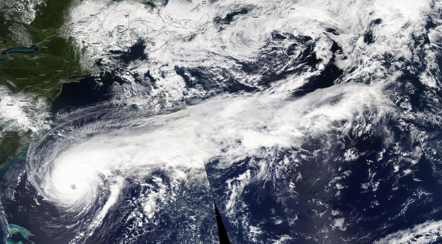
NASA’s Aqua satellite is one in a fleet of NASA satellites that provide data for research. NASA’s Aqua satellite provided a visible image of Major Hurricane Humberto and its very long “tail” of thunderstorms stretching past eastern Canada.

Hurricanes are the most powerful weather event on Earth. NASA’s expertise in space and scientific exploration contributes to essential services provided to the American people by other federal agencies, such as hurricane weather forecasting.

On Sept. 18, the Moderate Imaging Spectroradiometer or MODIS instrument that flies aboard NASA’s Aqua satellite passed over the northern Atlantic Ocean and gathered images of Hurricane Humberto. Humberto is such a large storm that the Aqua satellite had to make two Earth orbits to capture the entire storm. At NASA’s Goddard Space Flight Center in Greenbelt, Maryland, those images were put together to form a complete picture of Humberto.

Although Humberto’s eye was just about 490 miles (785 km) west-southwest of Bermuda at the time of the Aqua overpass, the thick band of thunderstorms east of the center stretched beyond eastern Canada!

On Sept. 19, the National Hurricane Center (NHC) said, “Humberto’s satellite presentation continues to be outstanding with a large ragged eye and surrounded by deep convection.”

The NHC said, “At 8 a.m. EDT (1200 UTC), the eye of Hurricane Humberto was located by satellite near latitude 31.8 degrees north and longitude 68.9 degrees west. Humberto has increased its forward speed and is moving toward the east-northeast near 16 mph (26 kph). This general motion with an additional increase in forward speed is expected through early Thursday, followed by a northeastward to north-northeastward motion through Friday.

Maximum sustained winds are near 115 mph (185 kph) with higher gusts.  Humberto is a category 3 hurricane on the Saffir-Simpson Hurricane Wind Scale.  Some fluctuations in intensity are likely during the next day or so, but Humberto should remain a powerful hurricane through early Thursday.  A steady weakening trend should begin later on Thursday, Sept. 19.

Hurricane-force winds extend outward up to 60 miles (95 km) from the center and tropical-storm-force winds extend outward up to 175 miles (280 km).  The estimated minimum central pressure is 951 millibars.

On the NHC forecast track, the core of Humberto is expected to pass just to the northwest and north of Bermuda later tonight.

###

For updated forecasts, visit: https://www.nhc.noaa.gov

By Rob Gutro

NASA’s Goddard Space Flight Center

Media Contact
Rob Gutro
[email protected]

Original Source

https://blogs.nasa.gov/hurricanes/2019/09/18/humberto-atlantic-ocean-4/

Tags: Atmospheric ChemistryAtmospheric ScienceClimate ChangeClimate ScienceEarth ScienceMeteorologyTechnology/Engineering/Computer ScienceTemperature-Dependent PhenomenaWeather/Storms
Share13Tweet8Share2ShareShareShare2

Related Posts

Macrophage-T Cell Interaction Boosts SLAMF1 in TB Defense

Macrophage-T Cell Interaction Boosts SLAMF1 in TB Defense

August 2, 2025
Strawberry Notch 1 Protects Neurons by Regulating Yeats4

Strawberry Notch 1 Protects Neurons by Regulating Yeats4

August 2, 2025

Revolutionary AI Tool Requires Minimal Data to Analyze Medical Images

August 1, 2025

Innovative Acid-Base Bifunctional Catalyst Enhances Production of Essential Lithium-Ion Battery Material

August 1, 2025
Please login to join discussion

POPULAR NEWS

  • Blind to the Burn

    Overlooked Dangers: Debunking Common Myths About Skin Cancer Risk in the U.S.

    60 shares
    Share 24 Tweet 15
  • Dr. Miriam Merad Honored with French Knighthood for Groundbreaking Contributions to Science and Medicine

    46 shares
    Share 18 Tweet 12
  • Study Reveals Beta-HPV Directly Causes Skin Cancer in Immunocompromised Individuals

    38 shares
    Share 15 Tweet 10
  • Sustainability Accelerator Chooses 41 Promising Projects Poised for Rapid Scale-Up

    35 shares
    Share 14 Tweet 9

About

We bring you the latest biotechnology news from best research centers and universities around the world. Check our website.

Follow us

Recent News

Macrophage-T Cell Interaction Boosts SLAMF1 in TB Defense

Strawberry Notch 1 Protects Neurons by Regulating Yeats4

Revolutionary AI Tool Requires Minimal Data to Analyze Medical Images

  • Contact Us

Bioengineer.org © Copyright 2023 All Rights Reserved.

Welcome Back!

Login to your account below

Forgotten Password?

Retrieve your password

Please enter your username or email address to reset your password.

Log In
No Result
View All Result
  • Homepages
    • Home Page 1
    • Home Page 2
  • News
  • National
  • Business
  • Health
  • Lifestyle
  • Science

Bioengineer.org © Copyright 2023 All Rights Reserved.