Credit: Image Courtesy: NASA Worldview, Earth Observing System Data and Information System (EOSDIS).
NASA’s Terra satellite provided a visible image that showed Tropical Storm Omar had weakened to a depression as it continued to be battered by strong upper level winds.
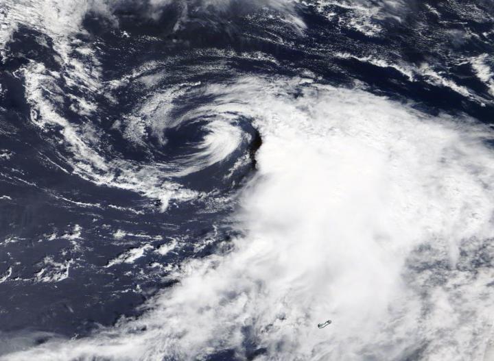
NASA Satellite View
The Moderate Resolution Imaging Spectroradiometer or MODIS instrument that flies aboard NASA’s Terra satellite captured a visible image of Tropical Storm Omar on Sept. 2 at 1:30 p.m. EDT that showed outside winds pushing the bulk of clouds and storms east of the center. Using visible imagery, like this image from Terra, in addition to microwave and infrared satellite imagery, forecasters downgraded Omar from a tropical storm to a depression.
Satellite imagery was created using NASA’s Worldview product at NASA’s Goddard Space Flight Center in Greenbelt, Md.
In the next National Hurricane Center (NHC) advisory at 5 p.m. EDT, Omar was downgraded to a depression. This image and other imagery “showed the system remains sheared with a bursting pattern on satellite, occasionally exposing the center, and a large area of curved bands in the southeastern quadrant of the circulation,” said Eric Blake, Senior Hurricane Specialist at NOAA’s National Hurricane Center in Miami, Fla.
About Wind Shear
In general, wind shear is a measure of how the speed and direction of winds change with altitude. Tropical cyclones are like rotating cylinders of winds. Each level needs to be stacked on top each other vertically in order for the storm to maintain strength or intensify. Wind shear occurs when winds at different levels of the atmosphere push against the rotating cylinder of winds, weakening the rotation by pushing it apart at different levels. In the case of Omar, strong outside winds from the north-northwest were pushing clouds to the south-southeast of the center of circulation.
Omar on Sept. 3
Despite the strong wind shear, Omar continued to hold onto depression status on Sept. 3. At 5 a.m. EDT (0900 UTC), the center of Tropical Depression Omar was located near latitude 36.3 degrees north and longitude 62.4 degrees west. That is about 310 miles (495 km) north-northeast of Bermuda.
Omar is moving toward the east near 14 mph (22 kph), and this general motion is expected to continue through tonight, accompanied by a decrease in forward speed. A turn toward the east-northeast and northeast is expected Friday and Friday night. Maximum sustained winds are near 35 mph (55 kph) with higher gusts. The estimated minimum central pressure is 1005 millibars.
NHC Hurricane Specialist Robbie Berg noted, “Amazingly, 50 knots of north-northwesterly shear has not been enough to prevent deep convection from developing, likely because Omar remains in an unstable thermodynamic environment and over [warm] sea surface temperatures of 27-28 degrees Celsius [80.6 to 82.4 degrees Fahrenheit].” Tropical cyclones require sea surface temperatures as warm as 26.6C (80F) to maintain strength. Warmer sea surface temperatures can help intensify a storm.
NHC forecasters expect dissipation by Sunday, Sept. 6 since all global computer forecast models indicate that the remnant low’s circulation should open up into a trough [elongated area of low pressure] by then.
About NASA’s Worldview and Terra Satellite
NASA’s Earth Observing System Data and Information System (EOSDIS) Worldview application provides the capability to interactively browse over 700 global, full-resolution satellite imagery layers and then download the underlying data. Many of the available imagery layers are updated within three hours of observation, essentially showing the entire Earth as it looks “right now.”
NASA’s Terra satellite is one in a fleet of NASA satellites that provide data for hurricane research.
Tropical cyclones/hurricanes are the most powerful weather events on Earth. NASA’s expertise in space and scientific exploration contributes to essential services provided to the American people by other federal agencies, such as hurricane weather forecasting.
For updated forecasts, visit: http://www.
###
Media Contact
Rob Gutro
[email protected]
Original Source
https:/


