Credit: Credit: NASA/NRL
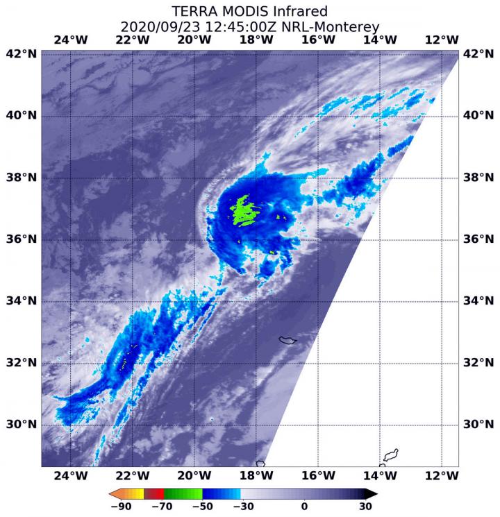
NASA’s Terra satellite passed over post-tropical storm Paulette after it had transitioned for a second time. Using infrared imagery, Terra found no strong storms remained.
Paulette has had quite a history. Paulette formed in the Central Atlantic Ocean on Sept. 6 as Tropical Depression Seventeen and became a tropical storm the next day. Paulette became a hurricane on Sept. 12. As a hurricane, Paulette’s eye passed directly over Bermuda, then weakened and became a post-tropical cyclone on Sept. 16 in the North Atlantic Ocean when it was located 450 miles (725 km) east-southeast of Cape Race Newfoundland, Canada. A Post-Tropical Storm is a generic term for a former tropical cyclone that no longer possesses sufficient tropical characteristics to be considered a tropical cyclone. Then on Sept. 22, the remnants of Paulette organized and re-formed into a tropical storm. Only to devolve again to a post-tropical storm later that day.
At 11 p.m. EDT on Sept. 22 (0300 UTC on Sept. 23), Dan Brown, Warning Coordination Meteorologist, Senior Hurricane Specialist at NOAA’s National Hurricane Center in Miami, Fla. noted, “Paulette had been devoid of deep convection since early Tuesday and the shallow convection mentioned in the previous advisory has also waned. Therefore, Paulette has again become a post-tropical cyclone.”
NASA’s Terra Satellite Examines Paulette
NASA’s Terra satellite uses infrared light to analyze the strength of storms by providing temperature information about the system’s clouds. The strongest thunderstorms that reach high into the atmosphere have the coldest cloud top temperatures.
On Sept. 23 at 8:45 a.m. EDT (1245 UTC), the Moderate Resolution Imaging Spectroradiometer or MODIS instrument that flies aboard NASA’s Terra satellite gathered infrared data on Paulette. There were no strong storms on the infrared MODIS imagery. The imagery found only one small area of convection where cloud top temperatures are as cold as minus 50 degrees Fahrenheit (minus 45.5 Celsius).
Final Status of Paulette
The last public advisory issued by the National Hurricane Center on Paulette was posted on Sept. 22 at 11 p.m. EDT (0300 UTC). At that time, the center of Post-Tropical Cyclone Paulette was located near latitude 34.8 degrees north and longitude 20.0 degrees west. That is about 445 miles (720 km) east-southeast of the Azores Islands. The Azores Islands are a Portuguese archipelago in the North Atlantic Ocean. They are located about 930 miles (1,500 km) from Lisbon, Portugal.
Maximum sustained winds are near 40 mph (65 kph) with higher gusts. Slow weakening is forecast. The post-tropical cyclone was moving toward the east near 12 mph (19 kph). An eastward to east-northeastward motion is forecast through midday Wednesday. A decrease in the forward motion along with turns to the southeast then south are expected late Wednesday through Thursday. A west-southwestward motion is forecast to begin by late this week.
Paulette’s Final Forecast
Post-tropical cyclone Paulette is expected to become a remnant low later today, Sept. 23.
###
NASA Researches Tropical Cyclones
Hurricanes/tropical cyclones are the most powerful weather events on Earth. NASA’s expertise in space and scientific exploration contributes to essential services provided to the American people by other federal agencies, such as hurricane weather forecasting.
For more than five decades, NASA has used the vantage point of space to understand and explore our home planet, improve lives and safeguard our future. NASA brings together technology, science, and unique global Earth observations to provide societal benefits and strengthen our nation. Advancing knowledge of our home planet contributes directly to America’s leadership in space and scientific exploration.
For updated forecasts. visit: http://www.
By Rob Gutro
NASA’s Goddard Space Flight Center
Media Contact
Rob Gutro
[email protected]
Original Source
https:/


