Credit: Credit: NASA Worldview
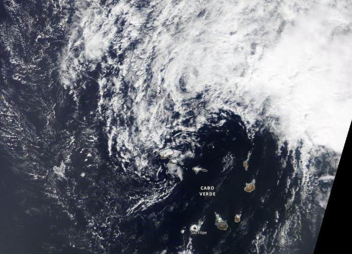
Tropical Depression Fifteen or TD15, developed off the west coast of Africa on Oct. 14 by 5 p.m. EDT. The depression never strengthened into a tropical storm before it reached the end of its life. NASA’s Terra satellite provided an image of TD15 after stretched out and ceased being a tropical cyclone.
At 5 a.m. EDT (0900 UTC) on Oct. 16 the remnants of Fifteen were located near latitude 17.3 degrees north and longitude 24.1 degrees west. That is about 90 miles (145 km) north of the Cabo Verde Islands. The remnants were moving toward the northwest near 8 mph (13 kph), and that motion should continue today. Maximum sustained winds were near 30 mph (45 kph) with higher gusts. The estimated minimum central pressure is 1009 millibars.
When NASA’s Terra satellite passed overhead at 1:30 p.m. local time, the Moderate Resolution Imaging Spectroradiometer or MODIS instrument aboard captured a visible image of TD15.
Visible imagery provides a look at the shape of the storm. A storm’s shape is a clue to forecasters that a storm is either strengthening or weakening. If a storm takes on a more rounded shape it is getting more organized and strengthening. Conversely, if it becomes less rounded or elongated, it is a sign the storm is weakening.
The image showed the surface circulation had become elongated from north to south. There were also just a few weak swirls in the circulation envelope, and has degenerated into a trough (elongated area) of low pressure. As a result, it is no longer a tropical cyclone. The system should weaken further today.
Hurricanes are the most powerful weather event on Earth. NASA’s expertise in space and scientific exploration contributes to essential services provided to the American people by other federal agencies, such as hurricane weather forecasting.
###
Media Contact
Rob Gutro
[email protected]
Original Source
https:/


