Credit: Credit: NASA/NRL
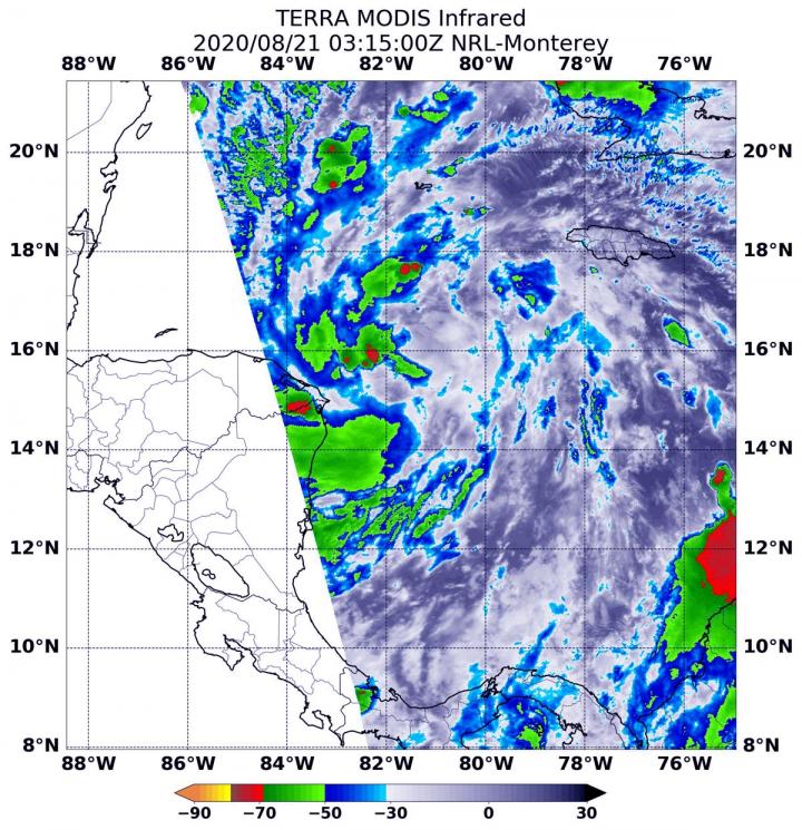
NASA’s Terra satellite gathered infrared data on Tropical Depression 14 as it moves through the Caribbean Sea. Infrared data was used to find the location of the strongest storms.
NASA’s Terra satellite uses infrared light to analyze the strength of storms by providing temperature information about the system’s clouds. The strongest thunderstorms that reach high into the atmosphere have the coldest cloud top temperatures.
On Aug. 21 at 0315 UTC (Aug. 20 at 11:15 p.m. EDT), the Moderate Resolution Imaging Spectroradiometer or MODIS instrument that flies aboard NASA’s Terra satellite gathered infrared data from the depression that found the coldest cloud top temperatures were as cold as or colder than minus 60 degrees Fahrenheit (minus 51.1 Celsius). The strongest storms were mostly on the western side of the storm. However, a fragmented band of thunderstorms extending to the southeast also contained strong storms. NASA research has found that cloud top temperatures that cold can generate heavy rainfall. Some of that heavy rain was affecting Mexico’s Yucatan Peninsula.
Several watches and warnings were in effect today, Aug. 21. A Hurricane Watch is in effect from Punta Herrero to Cancun, Mexico. A Tropical Storm Warning is in effect for the Bay Islands of Honduras and from Punta Herrero to Cancun, Mexico. A Tropical Storm Watch is in effect for north and west of Cancun to Dzilam, Mexico.
At 11 a.m. EDT (1500 UTC), the National Hurricane Center noted that the center of Tropical Depression Fourteen (TD14) was located near latitude 16.6 degrees north and longitude 84.1 degrees west. That is about 165 miles (270 km) east of Roatan, Honduras and about 325 miles (525 km) southeast of Cozumel, Mexico.
The depression is moving toward the northwest near 14 mph (22 kph). A slower northwestward motion is expected over the next couple of days, followed by an increase in speed by Sunday and Monday. Maximum sustained winds are near 35 mph (55 kph) with higher gusts.
NHC said, “Strengthening is forecast during the next couple of days, and the depression is expected to become a tropical storm later today. The system is forecast to be near or at hurricane strength when it reaches the Yucatan Peninsula of Mexico late Saturday. Some weakening is expected as it moves over the Yucatan Peninsula Saturday night. Afterward, restrengthening is forecast on Sunday as it moves offshore and enters the southern Gulf of Mexico.
On the forecast track, the center of the depression will move away from the coast of Honduras today and will approach the east coast of the Yucatan Peninsula of Mexico on Saturday. The center will then cross the northeastern part of the Yucatan Peninsula Saturday night and move over the central Gulf of Mexico toward the northwestern Gulf on Sunday and Monday.”
NASA Researches Tropical Cyclones
Hurricanes/tropical cyclones are the most powerful weather events on Earth. NASA’s expertise in space and scientific exploration contributes to essential services provided to the American people by other federal agencies, such as hurricane weather forecasting.
For more than five decades, NASA has used the vantage point of space to understand and explore our home planet, improve lives and safeguard our future. NASA brings together technology, science, and unique global Earth observations to provide societal benefits and strengthen our nation. Advancing knowledge of our home planet contributes directly to America’s leadership in space and scientific exploration.
For updated forecasts. visit: http://www.
###
Media Contact
Rob Gutro
[email protected]
Original Source
https:/


