Credit: Credit: NASA/Chris Cassidy
Astronauts aboard the International Space Station provided images of Hurricane Laura as it continues to strengthen in the Gulf of Mexico. Laura is pushing waters from the Gulf of Mexico that could inundate coastal areas miles inland and evacuations are in progress.
Watches and Warnings on Aug. 25
On Aug. 25, NOAA’s National Hurricane Center (NHC) posted several watches and warnings on major Hurricane Laura.
A Storm Surge Warning is in effect for San Luis Pass, Texas to the mouth of the Mississippi River. A Storm Surge Warning means there is a danger of life-threatening inundation, from rising water moving inland from the coastline, during the next 36 hours in the indicated locations. Some of the storm surge forecasts are extreme. From Sea Rim State Park to Intracoastal City, La. including Sabine Lake and Calcasieu Lake, a 10- to 15-foot storm surge is forecast. From Intracoastal City to Morgan City including Vermilion Bay an 8- to 12-foot storm surge is forecast. For additional areas and storm surges, visit: http://www.
A Hurricane Warning is in effect from San Luis Pass, Texas to Intracoastal City, Louisiana.
A Tropical Storm Warning is in effect from Sargent, Texas to San Luis Pass and for areas east of Intracoastal City, Louisiana to the mouth of the Mississippi River.
A Storm Surge Watch is in effect for Freeport, Texas to San Luis Pass, Texas, from the mouth of the Mississippi River to Ocean Springs, Mississippi, and for Lake Pontchartrain, Lake Maurepas, and Lake Borgne.
A Hurricane Watch is in effect for from east of Intracoastal City to west of Morgan City, Louisiana.
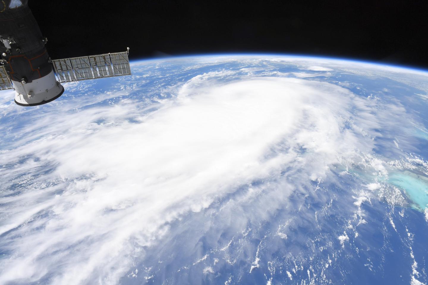
International Space Station Finds a Large Hurricane
Astronaut Chris Cassidy aboard the International Space Station captured this photo of Hurricane Laura on Aug. 25, 2020 as it moved through the Gulf of Mexico and continued to strengthen. Laura is a large hurricane. On Aug. 26, hurricane-force winds extend outward up to 70 miles (110 km) from the center and tropical-storm- force winds extend outward up to 175 miles (280 km).
NASA Sees Laura from One Million Miles Away
NASA’s EPIC Camera aboard NOAA’s DSCOVR satellite in orbit one million miles from Earth, captured a full disk image of the Atlantic Ocean side of the globe. Hurricane Laura is seen moving through the Gulf of Mexico.
Laura’s Status on Aug. 26, 2020 at 7 a.m. EDT
NOAA’s National Hurricane Center (NHC) reported at 7 a.m. EDT, the eye of Hurricane Laura was located near latitude 26.4 degrees north and longitude 91.4 degrees west. The eye is about 280 miles (450 km) south-southeast of Lake Charles, Louisiana and about 290 miles (465 km) southeast of Galveston, Texas.
Laura is moving toward the northwest near 15 mph (24 kph) and this general motion should continue today, followed by a north-northwestward motion tonight.
Data from NOAA and Air Force Hurricane Hunter aircraft indicate that maximum sustained winds have increased to near 115 mph (185 kph) with higher gusts. Laura is a dangerous category 3 hurricane on the Saffir-Simpson Hurricane Scale, and is forecast to continue strengthening into a category 4 hurricane later today. Buoy 42395, located just east of Laura’s eye, recently reported a sustained wind of 74 mph (119 km/h) and a wind gust of 107 mph (172 km/h) and a wave height of 37 feet (11 meters).
The latest minimum central pressure estimated from NOAA and Air Force reconnaissance aircraft data is 963 millibars.
Laura’s Forecast from NHC
The NHC warns that Laura may make landfall as a Category 4 hurricane and bring devastating effects. Heavy rain, dangerous storm surge, isolated tornadoes and hurricane-force sustained winds are expected. On the forecast track, Laura should approach the Upper Texas and southwest Louisiana coasts this evening and move inland near those areas tonight or Thursday morning.
NASA Researches Earth from Space
For more than five decades, NASA has used the vantage point of space to understand and explore our home planet, improve lives and safeguard our future. NASA brings together technology, science, and unique global Earth observations to provide societal benefits and strengthen our nation. Advancing knowledge of our home planet contributes directly to America’s leadership in space and scientific exploration.
###
For updated and detailed forecasts, visit: http://www.
By Rob Gutro
NASA’s Goddard Space Flight Center
Media Contact
Rob Gutro
[email protected]
Original Source
https:/


