Credit: NASA Worldview
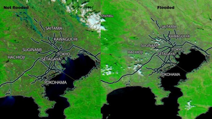
Typhoon Hagibis made landfall in Japan over the weekend of October 12 and 13, bringing damaging winds, rough surf and flooding rains. NASA’s Aqua satellite provided a visible image of the flooding caused by the torrential rainfall.
Hagibis made landfall just before 6 a.m. EDT (7 p.m. local time, Japan) on Oct. 12, on the Izu Peninsula, located southwest of Tokyo.
On Oct. 12 at 5 p.m. EDT (2100 UTC), the Joint Typhoon Warning Center issued their final bulletin on Tropical Cyclone Hagibis. The storm has moved off Japan and re-emerged in the Northwestern Pacific Ocean where it is becoming extra-tropical. On Oct. 12 at 5 p.m. EDT, Hagibis was located near 28.6 north latitude and 141.9 east longitude, about 113 nautical miles south-southeast of Misawa, Japan. Hagibis was speeding to the northeast at 36 knots (41 mph/67 kph) and had maximum sustained winds 65 knots (75 mph/120 kph), still at hurricane-strength.
In its wake, Hagibis dropped large amounts of rainfall that flooded neighborhoods and cut power to thousands of people. There were also landslides from the heavy rainfall. Rainfall totals in Hakone were the highest at 994 mm (39.1 inches). Izu City received 760 mm (27.7 inches) and Chichibu received 683 mm (26.8 inches).
On Oct. 15, the Moderate Resolution Imaging Spectroradiometer or MODIS instrument provided a visible view of Japan, where Typhoon Hagibis made landfall and dropped huge rain totals. The image was compared to a visible image taken of the same region before the typhoon and showed a marked difference and many flooded areas.
On Oct. 13, Japanese public broadcaster NHK reported at least 31 deaths had occurred and there were still over 186 people missing. The storm was becoming extra-tropical as it moved east toward Alaska.
On Oct. 15, Hagibis’ remnants reached Alaska. The Southcentral and Southwest Alaska Forecast Discussion from the National Weather Service Anchorage Alaska on Oct. 15 cited “A strong 958 millibar low [pressure area] (remnants of Hagibis) centered west of St. Matthew Island continues to slowly move northward. This low has brought hurricane force gusts and high seas to the Bering waters overnight.”
For updated Alaska forecasts, visit:
https:/
###
Media Contact
Rob Gutro
[email protected]
Original Source
https:/


