Credit: NASA/NRL
NASA infrared imagery revealed a burst of strength in Tropical Storm Hernan, located over the Gulf of California. At 12:30 a.m. EDT, NOAA’s National Hurricane Center or NHC noted that recent satellite-based wind data indicated Hernan was located northeast of previous estimates.
The body of water located between the Baja California Peninsula and the Mexican mainland is known as the Gulf of California. It is a marginal sea of the Pacific Ocean.
NHC noted late on Aug. 27, that Hernan appeared poorly organized, and despite a burst of strength, the storm weakened to a depression.
Infrared Data Provides a Temperature Check
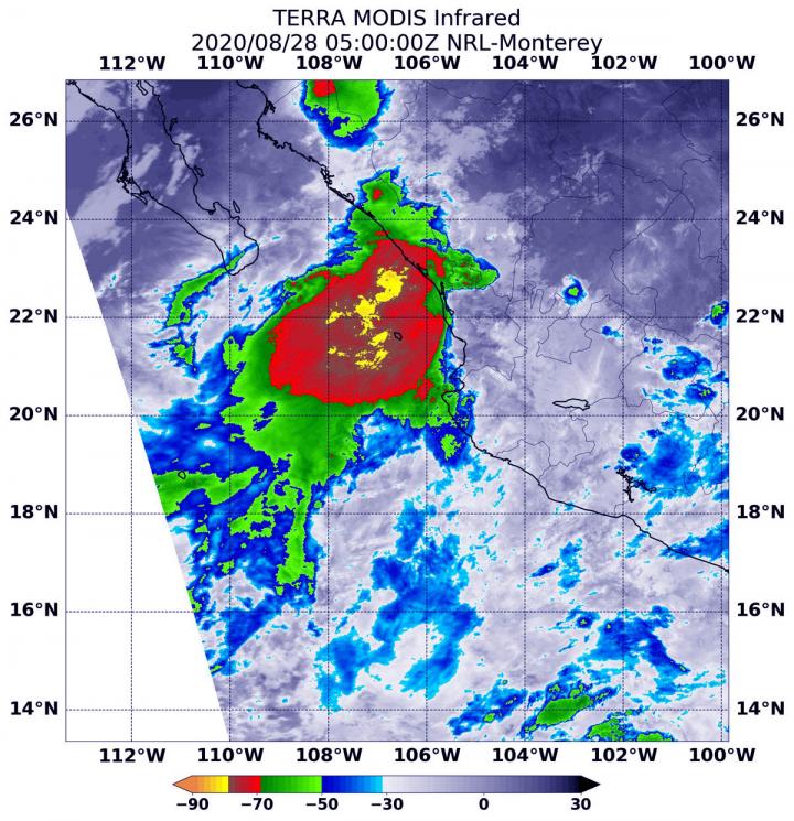
Infrared data provides temperature information, and the strongest thunderstorms that reach highest into the atmosphere have the coldest cloud top temperatures.
On Aug. 28 at 1 a.m. EDT (0500 UTC), the Moderate Resolution Imaging Spectroradiometer (MODIS) instrument aboard NASA’s Terra satellite captured an infrared image of cloud top temperatures in Hernan that showed what appears to be its final burst of strength. MODIS found the powerful thunderstorms that developed were as cold as or colder than minus 80 degrees Fahrenheit (minus 62.2 degrees Celsius) near Hernan’s center and over the Gulf of California. Surrounding that area were cloud top temperatures were as cold as minus 70 degrees Fahrenheit (minus 56.6. degrees Celsius). All of those areas were generating heavy rain, but within a couple of hours, they diminished.
Hernan Weakened to a Depression
The National Hurricane Center (NHC) noted at 5 a.m. EDT that Hernan had weakened to a depression and strong thunderstorms had weakened. NHC said, “Shortly after the release of the previous advisory, microwave imagery from a WindSat overpass showed no indication of a well-defined center near Hernan’s estimated location. However, there was a hint of a small vortex well to the northeast. Confidence is therefore fairly high that Hernan has persisted as a tropical cyclone, at least through 12 a.m. EDT (0400 UTC) this morning.” WindSat is the primary instrument aboard the Coriolis mission satellite, which is jointly sponsored by the U.S. Dept. of Defense Space Test Program and the U.S. Navy.
Hernan’s Status on Aug. 28, 2020
At 11 a.m. EDT (1500 UTC), the center of Tropical Depression Hernan was located near latitude 23.4 north, longitude 109.1 west, about 60 miles (100 km) northeast of the southern tip of Baja California, Mexico. The depression is moving toward the west-northwest near 21 mph (33 kph) and this motion is expected to continue through tonight. Maximum sustained winds have decreased to near 35 mph (55 kph) with higher gusts. Additional weakening is forecast, and Hernan is expected to degenerate to a remnant low-pressure area tonight. The remnants are expected to dissipate on Saturday. The estimated minimum central pressure is 1006 millibars.
Forecast from NHC
Based on decreasing satellite intensity estimates, Hernan was downgraded to a tropical depression. Additional weakening is forecast, and Hernan is expected to degenerate to a remnant low pressure area as it moves over the Baja California peninsula later today and tonight. The system is then expected to weaken to a trough (elongated area of low pressure) on Saturday.
###
NASA Researches Earth from Space
For more than five decades, NASA has used the vantage point of space to understand and explore our home planet, improve lives and safeguard our future. NASA brings together technology, science, and unique global Earth observations to provide societal benefits and strengthen our nation. Advancing knowledge of our home planet contributes directly to America’s leadership in space and scientific exploration.
For updated forecasts, visit: http://www.
By Rob Gutro
NASA’s Goddard Space Flight Center
Media Contact
Rob Gutro
[email protected]
Original Source
https:/


