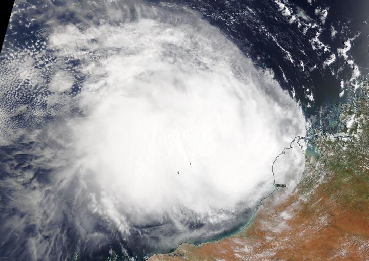
Credit: Credit: NASA Worldview
The low-pressure area that formed off Australia’s Kimberley coast and lingered there for a couple of days has moved west and developed into Tropical Cyclone Damien off the Pilbara coastline. NASA’s Terra satellite passed over the Southern Indian Ocean and provided forecasters with a visible image of the new tropical storm. The Pilbara Coast is also known as the northwest coast of Western Australia.
On Feb. 6, the Moderate Resolution Imaging Spectroradiometer or MODIS instrument that flies aboard NASA’s Terra satellite provided a visible image of Damien that showed the storm had a more rounded shape than it did the previous day as it continued to consolidate. A more rounded shape of a tropical cyclone indicates it is becoming a more organized storm. Satellite imagery revealed a small central dense overcast with rain bands wrapping in towards the low-level circulation center.
The Australian Bureau of Meteorology (ABM) issued warnings and watches for Damien on Feb. 6. The Warning Zone includes Wallal Downs to Mardie, including Port Hedland, Karratha and Dampier. The Watch Zone extends from Mardie to Onslow, and the inland central Pilbara including Tom Price, Paraburdoo, Marble Bar and Nullagine. A Blue Alert is in effect for residents in or near Wallal Downs to Port Hedland and Mardie to Onslow but not including Onslow, (including the towns of Pannawonica, Tom Price, Paraburdoo, Nullagine and Marble Bar). A Yellow Alert is in effect for residents in or near Port Hedland to Mardie and south to Millstream (including the Town of Port Hedland, Whim Creek, Point Samson, Wickham, Roebourne, Karratha and Dampier).
At 11:00 p.m. AWST (10 a.m. EST) on Feb. 6, the ABM said Tropical Cyclone Damien had maximum sustained winds near 75 kilometers per hour (40 knots/47 mph) with higher gusts. It was located near latitude 17.5 degrees south and longitude 118.1 degrees east, about 315 kilometers (196 miles) north of Port Hedland and 385 kilometers (239 miles) north-northeast of Karratha. Damien is moving to the west-southwest at 20 kilometers (12 miles) per hour.
The tropical cyclone is expected to continue to intensify as it tracks to the west southwest. Damien is expected to turn south towards the Pilbara coast during Friday, Feb 7. ABM cautioned that, “Severe tropical cyclone impact is forecast for the Pilbara coast during Saturday, Feb. 8.”
NASA’s Terra satellite is one in a fleet of NASA satellites that provide data for hurricane research.
Tropical cyclones/hurricanes are the most powerful weather events on Earth. NASA’s expertise in space and scientific exploration contributes to essential services provided to the American people by other federal agencies, such as hurricane weather forecasting.
###
For updated forecasts from ABM, visit: http://www.
By Rob Gutro
NASA’s Goddard Space Flight Center
Media Contact
Rob Gutro
[email protected]
Original Source
https:/


