Credit: Credit: NASA Worldview
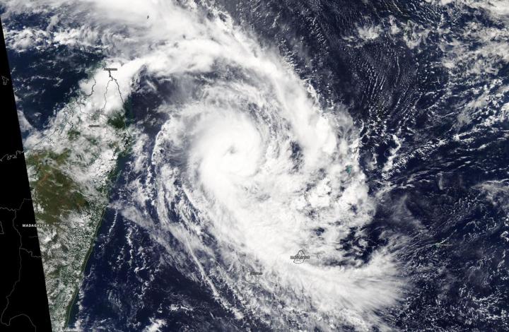
NASA’s Aqua satellite passed over the Southern Indian Ocean and captured an image of a well-developed Tropical Cyclone Herold at hurricane strength, east of Madagascar.
Herold formed on March 13 as Tropical Cyclone 22S and once it intensified into a tropical storm, it was renamed Herold. Herold continued to strengthen and is now at hurricane-force.
On March 16, the Moderate Resolution Imaging Spectroradiometer or MODIS instrument that flies aboard NASA’s Aqua satellite provided forecasters with a visible image of Tropical Cyclone Herold and showed a well-developed hurricane with a visible eye, although slightly obscured by high clouds. Powerful bands of thunderstorms circled the eye.
At 5 a.m. EDT (0900 UTC) on March 16, the center of Tropical Cyclone Herold was located near latitude 15.7 degrees south and longitude 54.2 degrees east, about 295 nautical miles north-northwest of St. Denis, La Reunion Island. Maximum sustained winds were near 80 knots (92 mph/148 kph).
The Joint Typhoon Warning Center or JTWC noted that Herold is forecast to turn to the southeast, passing just west of Rodrigues. The storm will strengthen to 90 knots (104 mph/167 kph) later today before becoming subtropical.
Tropical cyclones/hurricanes are the most powerful weather events on Earth. NASA’s expertise in space and scientific exploration contributes to essential services provided to the American people by other federal agencies, such as hurricane weather forecasting.
By Rob Gutro
NASA’s Goddard Space Flight Center
###
Media Contact
Rob Gutro
[email protected]
Original Source
https:/


