• HOME
  • NEWS
  • EXPLORE
    • CAREER
      • Companies
      • Jobs
    • EVENTS
    • iGEM
      • News
      • Team
    • PHOTOS
    • VIDEO
    • WIKI
  • BLOG
  • COMMUNITY
    • FACEBOOK
    • INSTAGRAM
    • TWITTER
Sunday, August 17, 2025
BIOENGINEER.ORG
No Result
View All Result
  • Login
  • HOME
  • NEWS
  • EXPLORE
    • CAREER
      • Companies
      • Jobs
        • Lecturer
        • PhD Studentship
        • Postdoc
        • Research Assistant
    • EVENTS
    • iGEM
      • News
      • Team
    • PHOTOS
    • VIDEO
    • WIKI
  • BLOG
  • COMMUNITY
    • FACEBOOK
    • INSTAGRAM
    • TWITTER
No Result
View All Result
Bioengineer.org
No Result
View All Result
Home NEWS Science News Science

NASA sees strong storms in developing gulf system 91L

Bioengineer by Bioengineer
June 3, 2019
in Science
Reading Time: 2 mins read
0
Share on FacebookShare on TwitterShare on LinkedinShare on RedditShare on Telegram

IMAGE

Credit: NASA/NRL

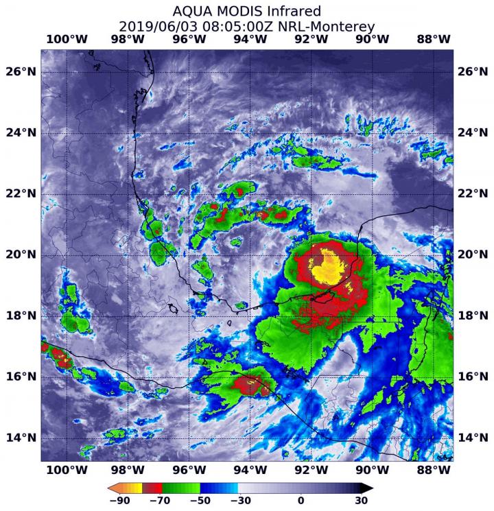
NASA’s Aqua satellite used infrared light to analyze the strength of storms in the developing low pressure area designated as System 91L is it moved through the Gulf of Campeche just north of Mexico’s Yucatan Peninsula.

Infrared data provides temperature information, and the strongest thunderstorms that reach high into the atmosphere have the coldest cloud top temperatures.

On June 3 at 4:05 a.m. EDT (0805 UTC), the Moderate Imaging Spectroradiometer or MODIS instrument that flies aboard NASA’s Aqua satellite gathered infrared data on developing System 91L. Strongest thunderstorms created a southern ring around the center from west to east, where cloud top temperatures were as cold as minus 80 degrees Fahrenheit (minus 62.2 Celsius). Cloud top temperatures that cold indicate strong storms with the potential to generate heavy rainfall. Those strongest storms were located just off the coast of the state of Campeche and the eastern part of the state of Tabasco.

On June 3 at 2 p.m. EDT, the National Hurricane Center (NHC) noted that System 91L has a medium chance to develop into a depression within the next 24 hours. NHC Forecaster Zelinsky noted in the update, “Showers and thunderstorms associated with a broad area of low pressure located over the Bay of Campeche have become a little better organized since yesterday. However, recent satellite-based wind data indicate that the circulation of the low is elongated and poorly defined.”

This system is forecast to move slowly northwestward toward the northeastern coast of Mexico, and could become a tropical cyclone before it moves inland in a day or two.

Even if System 91L does not develop into a tropical cyclone, forecasters at NHC said the disturbance will likely produce heavy rainfall over portions of southern and eastern Mexico during the next few days. Heavy rainfall is also likely to spread over southeastern Texas and Louisiana through Thursday.

Several computer models take System 91L on a northerly path, and interests along the Gulf coast of Mexico should monitor the progress of this system.

###

For updated forecasts, visit: https://www.nhc.noaa.gov

By Rob Gutro

NASA’s Goddard Space Flight Center

Media Contact
Rob Gutro
[email protected]

Original Source

https://blogs.nasa.gov/hurricanes/2019/06/03/91l-atlantic-ocean/

Tags: Atmospheric ChemistryAtmospheric ScienceClimate ChangeClimate ScienceEarth ScienceMeteorologyTechnology/Engineering/Computer ScienceTemperature-Dependent PhenomenaWeather/Storms
Share13Tweet7Share2ShareShareShare1

Related Posts

Five or more hours of smartphone usage per day may increase obesity

July 25, 2019
IMAGE

NASA’s terra satellite finds tropical storm 07W’s strength on the side

July 25, 2019

NASA finds one burst of energy in weakening Depression Dalila

July 25, 2019

Researcher’s innovative flood mapping helps water and emergency management officials

July 25, 2019
Please login to join discussion

POPULAR NEWS

  • blank

    Molecules in Focus: Capturing the Timeless Dance of Particles

    140 shares
    Share 56 Tweet 35
  • Neuropsychiatric Risks Linked to COVID-19 Revealed

    79 shares
    Share 32 Tweet 20
  • Modified DASH Diet Reduces Blood Sugar Levels in Adults with Type 2 Diabetes, Clinical Trial Finds

    59 shares
    Share 24 Tweet 15
  • Predicting Colorectal Cancer Using Lifestyle Factors

    47 shares
    Share 19 Tweet 12

About

We bring you the latest biotechnology news from best research centers and universities around the world. Check our website.

Follow us

Recent News

Mpox Virus Impact in SIVmac239-Infected Macaques

Epigenetic Mechanisms Shaping Thyroid Cancer Therapy

Seismic Analysis of Masonry Facades via Imaging

  • Contact Us

Bioengineer.org © Copyright 2023 All Rights Reserved.

Welcome Back!

Login to your account below

Forgotten Password?

Retrieve your password

Please enter your username or email address to reset your password.

Log In
No Result
View All Result
  • Homepages
    • Home Page 1
    • Home Page 2
  • News
  • National
  • Business
  • Health
  • Lifestyle
  • Science

Bioengineer.org © Copyright 2023 All Rights Reserved.