Credit: Credit: NASA JPL/Heidar Thrastarson
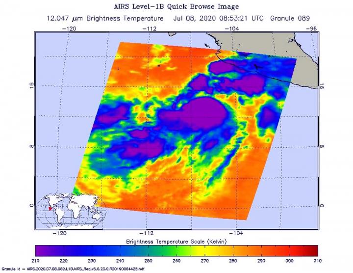
The analysis of Tropical Cyclone Cristina’s cloud top temperatures revealed some bands of thunderstorms were developing and wrapping around the center of the storm’s circulation.
Banding thunderstorms are generally an indication that a tropical cyclone is getting more organized.
How Tropical Cyclones Form
Tropical cyclones are like giant engines that use warm, moist air as fuel. The warm, moist air over the ocean rises upward from near the surface. As the warm air rises, it causes an area of lower air pressure near the surface. Air from surrounding areas with higher air pressure pushes in to the low-pressure area. Then that “new” air becomes warm and moist and rises, too. As the warm air continues to rise, the surrounding air swirls in to take its place. As the warmed, moist air rises and cools off, the water in the air forms clouds. The whole system of clouds and wind spins and grows, fed by the ocean’s heat and water evaporating from the surface.
NASA Uses Infrared Light to Analyze Storms
One of the ways NASA researches tropical cyclones is by using infrared data that provides temperature information. Cloud top temperatures provide information to forecasters about where the strongest storms are located within a tropical cyclone (which are made of hundreds of thunderstorms).
Tropical cyclones do not always have uniform strength. Some quadrants of a tropical cyclone contain more powerful thunderstorms than other quadrants. Temperature data indicates where those strongest storms are located. The stronger the storms, the higher they extend into the troposphere, and the colder the cloud temperatures.
On June 8 at 4:20 p.m. EDT (2020 UTC) NASA’s Aqua satellite analyzed the storm using the Atmospheric Infrared Sounder or AIRS instrument. AIRS found temperatures as cold as or colder than minus 63 degrees Fahrenheit (minus 53 degrees Celsius). NASA research has shown that cloud top temperatures that cold indicate strong storms that have the capability to create heavy rain.
Those cold temperatures were found around the center and in a developing band of thunderstorms northeast of the center. Satellite data showed the center was located underneath the northeastern side of the main area of convection due to moderate vertical wind shear. The AIRS image also showed banding features were developing across the northern portion of the circulation. One band of thunderstorms northeast of center brought rainfall to part of the coast of southwestern Mexico.
Cristina’s Status on July 9, 2020
Overnight from July 8 to July 9 although deep convection and strong thunderstorm development had been increasing, the overall cloud pattern and structure of the storm changed little and it continued to lack banding features.
At 5 a.m. EDT (0900 UTC) on July 9, the center of Tropical Storm Cristina was located near latitude 16.8 degrees north and longitude degrees 109.4 west. That is about 370 miles (590 km) west-southwest of Manzanillo Mexico. The estimated minimum central pressure is 995 millibars.
NOAA’s National Hurricane Center (NHC) said Cristina was moving toward the west-northwest near 12 mph (19 kph), and this motion with an increase in forward speed is expected during the next few days. On the forecast track, Cristina will remain well offshore of the coast of Mexico.
Maximum sustained winds were near 65 mph (100 kph) with higher gusts. Some strengthening is forecast and Cristina could become a hurricane by Friday.
Tropical cyclones/hurricanes are the most powerful weather events on Earth. NASA’s expertise in space and scientific exploration contributes to essential services provided to the American people by other federal agencies, such as hurricane weather forecasting.
The AIRS instrument is one of six instruments flying on board NASA’s Aqua satellite, launched on May 4, 2002.
For updated forecasts, visit: http://www.
###
Media Contact
Rob Gutro
[email protected]
Original Source
https:/


