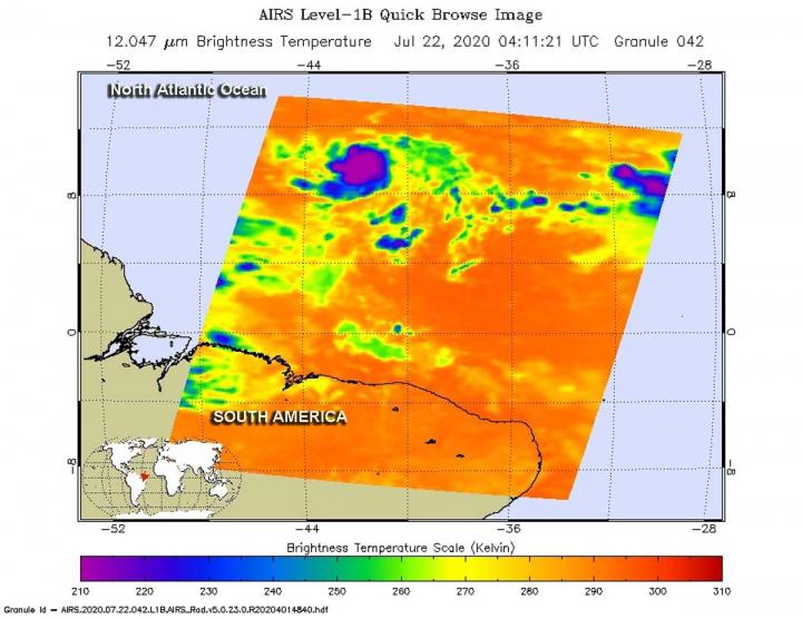
Credit: Credit: NASA JPL/Heidar Thrastarson
The seventh named tropical cyclone of the North Atlantic Ocean has formed, and like some others this season, it has broken a record. NASA’s Aqua satellite provided a look at the small record-breaker.
The National Hurricane Center (NHC) reports that Gonzalo is the earliest seventh named storm on record in the Atlantic basin, beating Gert of 2005 by 2 days. Tropical Depression Seven formed on July 21 by 5 p.m. EDT in the Central North Atlantic Ocean, and by 8:50 a.m. EDT on July 22 it strengthened into a tropical storm and was renamed Gonzalo.
One of the ways NASA researches tropical cyclones is using infrared data that provides temperature information. The AIRS instrument aboard NASA’s Aqua satellite captured a look at those temperatures in Gonzalo and gave insight into the size of the storm and its rainfall potential.
Cloud top temperatures provide information to forecasters about where the strongest storms are located within a tropical cyclone. Tropical cyclones do not always have uniform strength, and some sides have stronger sides than others. The stronger the storms, the higher they extend into the troposphere, and the colder the cloud temperatures. NASA provides that data to forecasters at NOAA’s National Hurricane Center or NHC so they can incorporate it in their forecasting.
On July 22 at 12:11 a.m. EDT (0411 UTC) NASA’s Aqua satellite analyzed the storm using the Atmospheric Infrared Sounder or AIRS instrument. AIRS found coldest cloud top temperatures as cold as or colder than minus 63 degrees Fahrenheit (minus 53 degrees Celsius). NASA research has shown that cloud top temperatures that cold indicate strong storms that have the capability to create heavy rain.
By 11 a.m. EDT, the NHC noted, “Satellite imagery indicates that the cyclone has become significantly better organized since the last advisory. Visible imagery shows a well-defined central dense overcast with a hint of an eye and an outer convective band in the western semicircle, while a microwave overpass showed a well-defined inner convective ring feature.”
At 11 a.m. EDT (1500 UTC), NHC reported the center of Tropical Storm Gonzalo was located near latitude 9.9 degrees north and longitude 43.6 degrees west. That is about 1,205 miles (1,935 km) east of the southern Windward Islands. Gonzalo is moving toward the west near 14 mph (22 kph). A general westward motion at a faster forward speed is expected during the next few days. The estimated minimum central pressure is 1000 millibars.
Maximum sustained winds have increased to near 50 mph (85 kph) with higher gusts. Gonzalo is a small tropical cyclone, as tropical-storm-force winds extend outward only up to 25 miles (35 km) from the center. Additional strengthening is forecast during the next couple of days, and Gonzalo is expected to become a hurricane by Thursday, July 23.
Interests in the southern Windward Islands should monitor the progress of this system.
The AIRS instrument is one of six instruments flying on board NASA’s Aqua satellite, launched on May 4, 2002.
For more than five decades, NASA has used the vantage point of space to understand and explore our home planet, improve lives and safeguard our future. NASA brings together technology, science, and unique global Earth observations to provide societal benefits and strengthen our nation. Advancing knowledge of our home planet contributes directly to America’s leadership in space and scientific exploration.
For updated forecasts, visit: http://www.
By Rob Gutro
NASA’s Goddard Space Flight Center
###
Media Contact
Rob Gutro
[email protected]
Original Source
https:/


