Credit: Credit: NASA/NOAA/NRL
Hurricane Teddy has transitioned to a large post-tropical cyclone over eastern Canada. Using a NASA satellite rainfall product that incorporates data from satellites and observations, NASA estimated Teddy’s rainfall rates. In addition to the heavy rainfall, Teddy causing destructive waves and strong winds today, Sept. 23, for portions of Atlantic Canada.
Teddy made landfall in the Sheet Harbour area of Nova Scotia on the province’s Eastern Shore around 7:30 a.m. EDT, Sept. 23.
Warnings and Watches in Effect on Sept. 23
NOAA’s National Hurricane Center (NHC) issued warnings and watches for Teddy on Sept. 23. Tropical Storm Warning is in effect for the south coast of Nova Scotia from Digby to Meat Cove, and for Port aux Basques to Francois, Newfoundland, Canada.
A Tropical Storm Watch is in effect for Meat Cove to Tidnish, Nova Scotia, and from north of Digby to Fort Lawrence, Nova Scotia, and for the Magdalen Islands, Quebec and Prince Edward Island.
What is a Post-tropical and Extra-tropical Cyclone?
At 11 p.m. EDT on Sept. 22, U.S. Navy Hurricane Specialist Dave Roberts at the NHC said, “Extratropical transition has been ongoing since last night, with the cyclone’s associated rain shield expanding over a great distance in the northern semicircle. In addition, multiple dropsonde observations from the Air Force Reserve hurricane hunters and buoy data show a sharp temperature gradient of nearly 20 degrees F from northwest quadrant to the southeast, indicative of the cyclone’s involvement with the strong baroclinic frontal zone. Accordingly, Teddy has become a strong post-tropical extratropical cyclone.”
NHC defines a post-tropical cyclone as a former tropical cyclone. This generic term describes a cyclone that no longer possesses sufficient tropical characteristics to be considered a tropical cyclone. Post-tropical cyclones can continue carrying heavy rains and high winds. Former tropical cyclones that have become fully extratropical or remnant lows are both classes of post-tropical cyclones.
What does Extra-tropical Mean?
When a storm becomes extra-tropical it means that a tropical cyclone has lost its “tropical” characteristics. The National Hurricane Center defines “extra-tropical” as a transition that implies both poleward displacement (meaning it moves toward the north or south pole) of the cyclone and the conversion of the cyclone’s primary energy source from the release of latent heat of condensation to baroclinic (the temperature contrast between warm and cold air masses) processes. It is important to note that cyclones can become extratropical and still retain winds of hurricane or tropical storm force.
Teddy’s Status on Sept. 23
At 8 a.m. EDT (1200 UTC), the center of Post-Tropical Cyclone Teddy was located near latitude 44.8 degrees north and longitude 62.3 degrees west. That is 65 miles (105 km) east-northeast of Halifax, Nova Scotia, Canada. The post-tropical cyclone is moving toward the north-northeast near 23 mph (37 kph), and this motion, with an increase in forward speed, is expected for the next day or so. On the forecast track, the center will move over eastern Nova Scotia soon, and then near or over Newfoundland by tonight, and be east of Labrador on Thursday.
Maximum sustained winds are near 65 mph (100 km/h) with higher, gusts. Some weakening is forecast during the next day or so, but Teddy should remain a strong post-tropical cyclone while passing over Nova Scotia and near Newfoundland. Teddy is a huge storm. Tropical-storm-force winds extend outward up to 520 miles (835 km) from the center. The estimated minimum central pressure is 963 millibars.
Estimating Teddy’s Rainfall Rates from Space
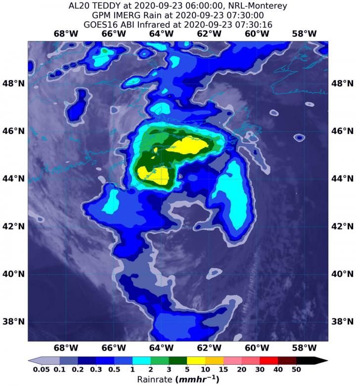
NASA’s Integrated Multi-satellitE Retrievals for GPM or IMERG, which is a NASA satellite rainfall product, estimated on Sept. 23 at 3:30 a.m. EDT (0730 UTC) that Teddy was generating between 5 and 15 mm (0.20 and 0.60 inches) of rain per hour around the center of circulation. Rainfall throughout most of the storm was estimated as falling at a rate between 0.3 and 2 mm (0.01 to 0.08 inches) per hour.
At the U.S. Naval Laboratory in Washington, D.C., the IMERG rainfall data was overlaid on infrared imagery from NOAA’s GOES-16 satellite to provide a full extent of the storm.
NHC Key Messages
The National Hurricane Center (NHC) issued three key messages about Teddy on Sept. 23:
Teddy is expected remain a powerful post-tropical cyclone while it moves near or over portions of Atlantic Canada through tonight. The most significant hazard expected from Teddy is large destructive waves forecast along the southern coast of Nova Scotia today.
Very large swells produced by Teddy are expected to affect portions of Bermuda, the Leeward Islands, the Greater Antilles, the Bahamas, the east coast of the United States, and Atlantic Canada during the next few days. These swells are expected to cause life-threatening surf and rip current conditions.
Tropical Storm Watches and Warnings are in effect for portions of Nova Scotia, Newfoundland, Prince Edward Island and the Magdalen Islands, and heavy rainfall across Atlantic Canada is expected through Thursday.
Teddy’s Fate in the Atlantic
NHC Senior Hurricane Specialist Richard Pasch said, “Teddy’s deep convection has been diminishing, but based on buoy observations the cyclone still has a strong circulation with a central pressure in the 950’s (millibars). Assuming a gradual spin down of the system since the earlier aircraft observations, the estimated maximum winds have dropped to just below hurricane strength. The system is expected to traverse Nova Scotia today as a strong extratropical cyclone, and move near Newfoundland by tonight. After passing east of Labrador on Thursday, the global models show Teddy merging with another large extratropical low over the north Atlantic.”
What Does IMERG Do?
This near-real time rainfall estimate comes from the NASA’s IMERG, which combines observations from a fleet of satellites, in near-real time, to provide near-global estimates of precipitation every 30 minutes. By combining NASA precipitation estimates with other data sources, we can gain a greater understanding of major storms that affect our planet.
What the IMERG does is “morph” high-quality satellite observations along the direction of the steering winds to deliver information about rain at times and places where such satellite overflights did not occur. Information morphing is particularly important over the majority of the world’s surface that lacks ground-radar coverage. Basically, IMERG fills in the blanks between weather observation stations.
###
NASA Researches Tropical Cyclones
Hurricanes/tropical cyclones are the most powerful weather events on Earth. NASA’s expertise in space and scientific exploration contributes to essential services provided to the American people by other federal agencies, such as hurricane weather forecasting.
For more than five decades, NASA has used the vantage point of space to understand and explore our home planet, improve lives and safeguard our future. NASA brings together technology, science, and unique global Earth observations to provide societal benefits and strengthen our nation. Advancing knowledge of our home planet contributes directly to America’s leadership in space and scientific exploration.
For more information about NASA’s IMERG, visit: https:/
For forecast updates on hurricanes, visit: http://www.
By Rob Gutro
NASA’s Goddard Space Flight Center
Media Contact
Rob Gutro
[email protected]
Original Source
https:/


